The Alpilles Roquemartine by Bike: The Integral
Live the Alpilles as you never did! With a massive character pronounced at the whim of its valleys and rocky ridges, vineyards and olive groves that invite you to stroll along small bucolic roads, and picturesque villages that contain a rich heritage, every turn of the wheel becomes a pleasant discovery.
19 points of interest

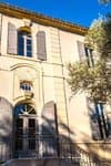
Façade de l'église Saint-Jacques-le-Majeur - ©Rémi Sérange - PNR Alpilles  Patrimony and history
The Saint-Jacques-le-Majeur
The church is the place of the Saint-Jacques chapel, they found writings dating from the eleventh century. and has been replaced to accommodate the growing number of parishioners. The building in front of you dates from 1783. He has had several downgrades during the Revolution, but also following the 1909 earthquake that caused the collapse of the bell tower.
Oratoire Saint-Roch de Mouriès - ©DR Patrimony and historySt. Roch oratory
Topped on a central pillar in stone, this small chapel was built in 1822, against cholera raging in the region. A niche was built, bullet-shaped, covered by a stone flat roof. A marble plaque was added to the building, where one can read "SAINT ROCH PRIEZ FOR US. 1822-1886 ".

Plantations d'oliviers avec couvert végétal - ©Rémi Sérange - PNR Alpilles  Produits du terroir
The route of the olive groves
On D24a connecting Mouriès to Aureille, you will drive for about 5km on a road punctuated by numerous olive groves. You can then explore all the various activities in relation with the planting of olive trees. These activities range from intensive farming with tight plants and bare soil to organic farming with widely spaced plants and vegetation cover.

Débroussaillage mosaïque du LIFE - ©Rémi Sérange - PNR Alpilles  Panorama
Mosaic plant
The irregular plant mosaic is the result of clearing work carried out under the LIFE program of the Alpilles. Its objective is to promote the reintegration of species living in the open air environment. The species include small game, such as the wild rabbit and red-legged partridge, that constitues the main food source for predatory birds of the Alpilles such as Bonelli's eagle and the Egyptian vulture.

Notre-Dame de l'Assomption - ©Rémi Sérange - PNR Alpilles Patrimony and historyNotre Dame de l'Assomption
Once you have reached Aureille, I invite you to make a detour in the center of the village to admire the church of Notre Dame de l’Assomption. The construction of this neo-Romanesque church was initiated by the parish priest, named Father Pauleau, who arrived in 1867 at Aureille. The first stone was laid by the Archbishop of Aix, George Chalandon, on 31 March of that year. His plans are the work of the architect Auguste Veran from Arles.

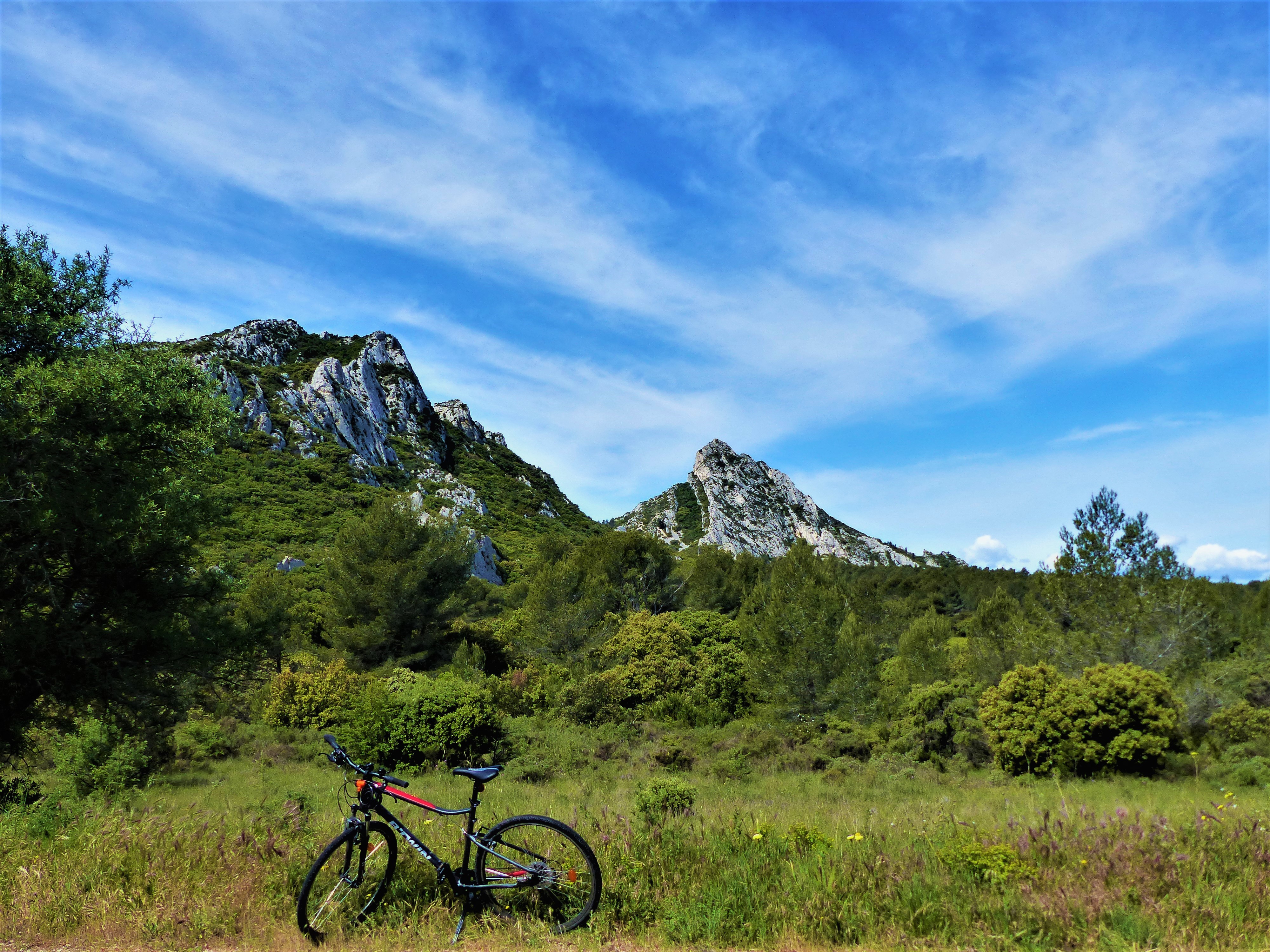
Sommet des Opies et sa tour - ©Rémi Sérange - PNR Alpilles PanoramaView of Les Civadières and Les Opies
Getting out of Aureille, it is possible to contemplate the presence of a set of rocky ridges. They are located southeast of the Alpilles and include Les Civadières and the highest point of the Regional Nature Park: Les Opies 498m high. Some of their rock walls are now the favorite site for many climbing lovers.
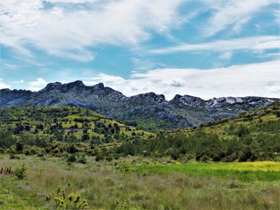
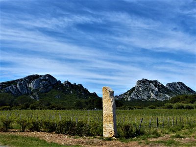
Vue sur les Civadières - ©Rémi Sérange - PNR Alpilles PanoramaView of the Civadières
Located in the immediate vicinity of the highest point of the Alpilles, the crests of Civadières, high of 446 m offer a broad panorama on the solid mass of Alpilles, Petit Luberon and Mont Ventoux. They are part of the most ancient geological formations of the Park, dating back from the Jurassic. ;
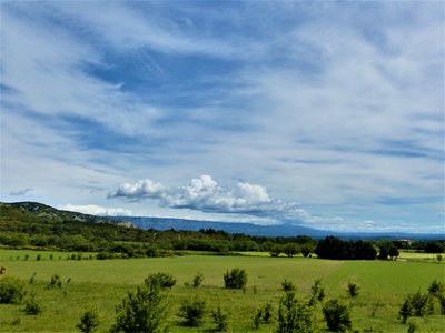
La plaine de Roquemartine - ©Rémi Sérange - PNR Alpilles PanoramaView on the Roquemartine lowland
This opening of the landscape, which follows a pine forest, reveals the Roquemartine lowland. It is between the eastern end of the Alpilles on the left and Mont Menu and Defens on the right. In the distance, one can also distinguish very clearly the first reliefs of the Petit Luberon. It forms a landscape where each element composes a harmonious whole, of a great serenity.
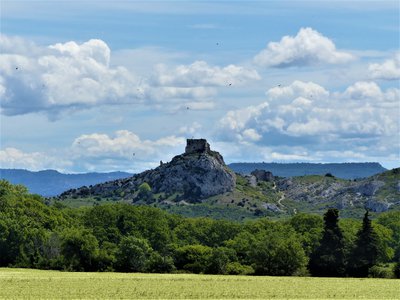
Château de Roquemartine - ©Rémi Sérange - PNR Alpilles Patrimony and historyRoquemartine castle
Also called "Queen Jeanne Castle", it dates from the twelfth century and belonged to the family of Alba. Below is the Church Saint-Sauveur, which was formerly the parish church of Roquemartine village. The castle and the church form an original landscape perched on a spur overlooking the lowland below. At the beginning of the seventeenth century, the castle is abandoned in favor of the New Roquemartine castle, in lowland. This site has been registered with the historical monuments in 1926.
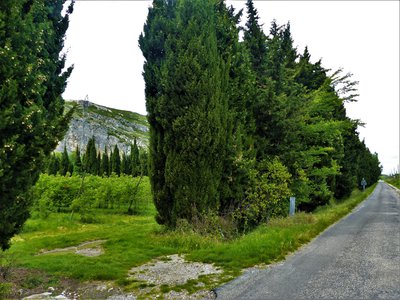
Plantation de fruitiers entourée de haies - ©Rémi Sérange - PNR Alpilles  Savoir-faire
Provençales hedges
Symbols of Provence, many hedges segment the territory and separate the various plots. Composed of cedar or cypress, these hedges have the primary function of protecting the various crops from mistral and frost. These trees are also known for their wood, very solid and fragrant, and have served to build the framework of many farmhouses of the Alpilles.
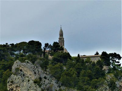
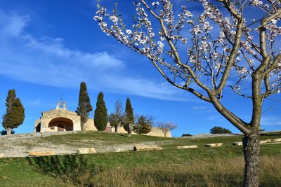
Chapelle Notre-Dame-de-Beauregard - ©Rémi Sérange - PNR Alpilles PanoramaView on the Notre-Dame de Beauregard Chapel
Place of Christian pilgrimage today, this promontory is a place of worship probably since the protohistory. Many vestiges of the altars were found on the site. The current chapel was erected in 1878 on the site of a chapel that had become too small to accommodate pilgrims. Many ex-voto testify to a great religious fervor granted to this place The building below is a former convent built by the Augustinians Déchaussés (17th century).
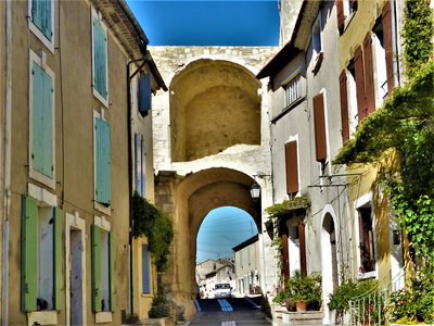
Intérieur de la porte Sainte-Anne - ©Rémi Sérange - PNR Alpilles Patrimony and historyMedieval Gate Sainte-Anne
West entrance of the second enclosure of Orgon, it is difficult to estimate exactly its age. But we know that it has seen many important personalities since the sixteenth century. Notably, François 1st, who returned from Italy in 1516, stopped a few hours before continuing to Tarascon; Pope Pius VII, who will stay in Orgon and was lodged at the Berne Hotel No. 13 rue Edmond Coste; or Napoleon I, who passed through Orgon to go to Elba island.
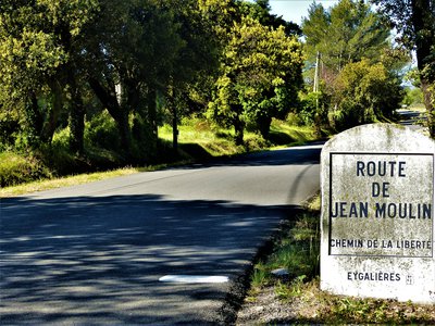
Borne de la route de Jean Moulin - ©Rémi Sérange - PNR Alpilles Patrimony and historyJean Moulin Road, Freedom Road
This road was inaugurated in 1978, nine years after the memorial at Salon-de-Provence which also pays tribute to Jean Moulin. It leaves Saint-Andiol and ends in Salon-de-Provence. Very attached to the Alpilles, where he owned a small country house, Jean Moulin chose this familiar land to be parachuted and to begin his mission of unification of resistance network of the unoccupied France.
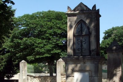
Chapelle St Sixte - Nancy01_Adobe Stock Patrimony and historySaint Sixtus Chapel
His name refers to Sixtus II, contemporary of St. Lawrence and pope of early Christian times. The chapel is located on an old place of worship: until the nineteenth century, it housed a pagan stele, which was then used as foot of holy water. The latter reflected a cult dedicated to the water. The first reference that is made regarding the chapel date of 1155. Significant changes were made in the sixteenth century. and seventeenth century, because it served as a lazaretto during the plagues of 1629 and 1720.
Le Calan de Rousset - ©Rémi Sérange - PNR Alpilles PanoramaView on the Calans
Here, the relief of the Alpilles is similar to limestone rocks forming a natural barrier. The latter limits access to the heart of the massif to small passages like the Pas du Suisse. On the left is the famous Calan de Rousset, isolated from the rest of the massif and 275 meters high.

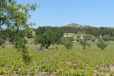
Entrée du domaine - ©Jason Gaydier - PNR Alpilles Produits du terroirThe Vallongue farmhouse
Located at the southeast end of the Alpilles ridges, the Vallongue domain has 38 hectares on which is produced wines and olive oils. These vineyards were the first to turn to organic farming, as of 1985! Reds, whites and rosés benefitted from Les Baux de Provence Appelation d'Origine Protégée (AOP) label and Alpilles of Vallongue Indicateur Géographique Protégé (IGP) label, proof a real know-how.
Vignobles du Gourgonnier - ©Rémi Sérange - PNR Alpilles Produits du terroirMas de Gourgonnier
Built in the mid-18th century, the mas was a farmhouse belonging to the abbey of Pierredon. It was in 1950 that the first vines were planted. As he became rapidly aware of benefiting excellent weather conditions, he turned to organic farming in 1975 by joining Nature et Progrès, then by receiving certification from Ecocert. At present, there are 45ha of vineyards and 20ha of olive groves.

La plaine de Maussane-les-Alpilles - ©Rémi Sérange - PNR Alpilles PanoramaView of the plain of Maussane
Before starting the descent and leaving the Alpilles Massif, you will face an open landscape framed by two bas-reliefs, Gypières on your right, and Castellas on your left. At the heart of this picture, you can distinguish the village of Maussane-les-Alpilles, its wet plain and, weather permitting, the surrounding area of Fontvieille.

Canal de la vallée des Baux - ©Rémi Sérange - PNR Alpilles  Water and rivers
The Baux valley canal
This canal, measuring 53km long, was subject to a long process of reflection and design. Designed in 1792, the project will be launched over a century later, in 1914. In a landscape of steppe, it was important to develop human presence and the economy as a hydraulic network irrigates the territory to help the crops survive. This canal supplies all to itself the southern part of the Alpilles.
Description
Back to the car park, take the D24 on the right for 225 m. At the crossroads, turn right on the Avenue Pasteur. Go to the church and then back to the starting parking for the hike.
1- At the roundabout take the D24 opposite the intersection with the D24a towards Aureille.
2- ON the right retrieve the D24a, walk by olive groves for 5 km, until Aureille.
3- Take the road on the left, direction Eygalières. Continue to the pass called "Pas de la Figuière". Join the intersection with the D25.
4- Go right up the D25 in direction of Eyguières. Continue for 7.5 km and join the junction with the D569.
5- (Caution, traffic!) Turn right on the D569, always towards Eyguières. At the roundabout, continue straight for 150 m.
6- Turn left in the direction of Sénas. Continue for 7 km.
7- cross the roundabout of the entrance of the city. 300 meters later, turn left on the path of "Donne", just before the level crossing. Continue to Orgon.
8- Go through Orgon via rue de la Fontaine and Edmond Coste Street. Continue through the rise of Paradise and Jean Moulin Avenue to the intersection with the D24b, after the sports complex.
9- At the intersection after the sports complex, take the D24b on the left and continue until Eygalières for about 7 km. Cross the village and continue on the D24b for 2 km.
10- Turn left on the D24, towards Mouriès. Continue for 2 km.
11- Take the D24 on the right, towards Mouriès. Continue for 6 km to the place called "Destet".
12- Turn right on the D78 towards Maussane-les-Alpilles.
13- At the junction with the D5, turn left towards Mouriès. Continue on this road until the intersection with the D17.
14- Turn left on Alphonse Daudet road, before the D17, then continue until you reach the roundabout of the departure.
- Departure : Tourism office, Mouriès
- Arrival : Mouriès
- Towns crossed : Mouriès, Aureille, Eygalières, Eyguières, Lamanon, Sénas, Orgon, Saint-Rémy-de-Provence, and Maussane-les-Alpilles
Forecast
Altimetric profile
Recommandations
Follow the red and white signs marked "Alpilles Roquemartine" of the Department of Bouches-du-Rhone.
For your safety, and for the preservation of forest areas, access to natural areas is regulated from June to September. Inquire during the summer period on 08 11 20 13 13 (price of a local call) or on www.bouches-du-rhone.pref.gouv.fr Download the application for free MYPROVENCE ENVIE DE BALADE (available on Appstore and Android Market).
Information desks
House of the Alpilles Regional Nature Park
2, boulevard Marceau, 13210 Saint-Rémy-de-Provence
Located in the heart of the city centre of Saint-Rémy-de-Provence, the House of the Alpilles Nature Park welcomes you to its completely renovated premises. This new vibrant place is multifunctional: it accommodates the Park's engineering team but also has a public reception space and showrooms. A true resource centre of the Park's heritage, it aims to support and promote locals, visitors and tourists on all 16 municipalities of the Park.
Open Monday to Friday, from 9 am at 12:30 pm and from 1:30 pm to 5 pm.
Free admission.

OTI Alpilles-en-Provence
Place Jean Jaurès, 13210 Saint-Rémy-de-Provence
Transport
Look for public transport times on the website www.lepilote.com in the town of Mouriès.
Access and parking
22 km north-west of Salon-de-Provence, by the D17, D17e, then D17.
Parking :
Report a problem or an error
If you have found an error on this page or if you have noticed any problems during your hike, please report them to us here: