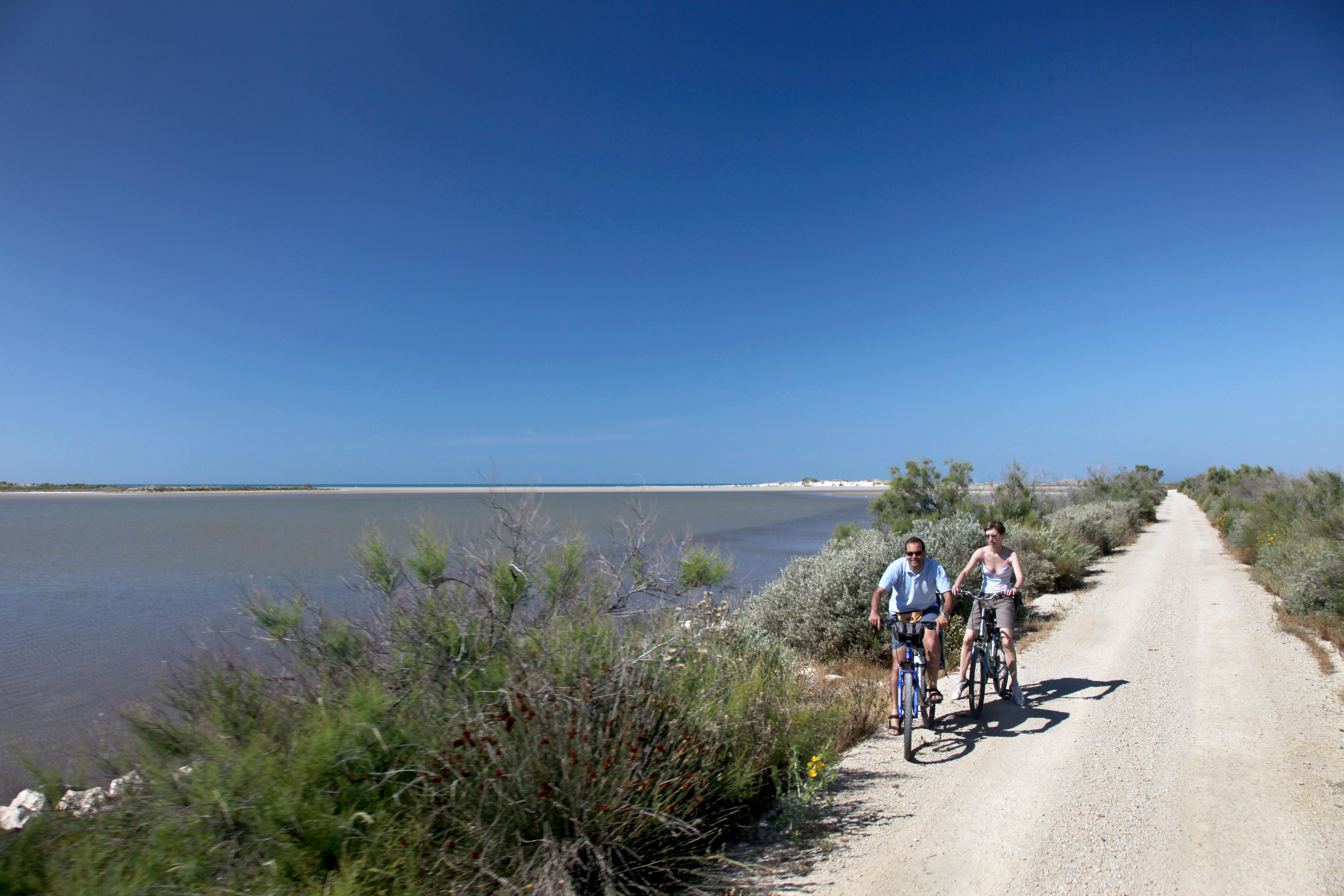
Pink flamingos and salt while you bike
Flamingos as companions and ponds as far as the eye can see, this hike can be found in the heart of the Camargue! You will appreciate the peace and the wide spaces that offer this course. Take the height, from the salt point of view, to have a sight on the salting tables and the camels: salt hills more than 10 m high.
9 points of interest

Ruines du château de la Tourvieille - Chloé Scannapiéco - PNR Camargue  Patrimony and history
The Tourvieille (or the Tourvieille or the Tanpan tower)
In the 15th century, the city was authorized by King René to build a defense tower (1614) at the main Rhone estuary at the time. Less than 50 years later, too far from river estuary, the tower became unnecessary. There are only a few remains visible in the heart of a terroir, where salty vegetation dominates as far as the eye can see. This building was listed as a historic monument in 1933 and integrated into the heritage of the littoral conservatory in 2008, which plans to preserve and enhance it.
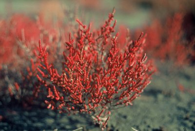
Salicorne annuelle rouge - Emmanuel Vialet - PNR Camargue  Flora
FloraGlasswort
Glasswort is a halophilic plant (magnet salt) that is a sansouïre feature. The leaves are replaced by small segments nested in each other Those extremities store the excess salt and the plant gets rid of it periodically. This plant also recovers rainwater that it stores in its fleshy parts to lower the salt concentration in its tissues. Annual species are edible: stems harvested in spring are crisp and salty.
Capucine Ser - PNR Camargue  Fauna
FaunaMigratory Birds
Thanks to its tranquillity and food resources, the Camargue is a travel hub for migratory birds. Two great seasons punctuate the year. September sees trans-Saharan migrants arriving from northern and eastern Europe preparing for their journey to Africa. They are joined soon after by the ducks and the thousands of sparrows who will stay in the marshes for the winter. At the same time, sedentary species, such as the flamingo, fled from Camargue to warmer regions.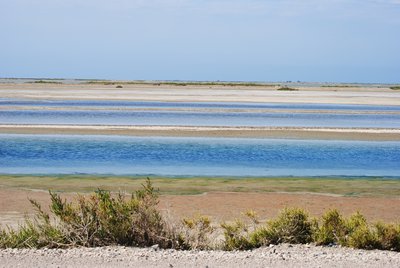
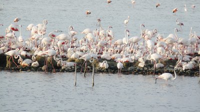
Lagune - Chloé Scannapiéco - PNR Camargue  Panorama
Salt marshes
Salt marshes are landscaped ponds in order to allow the concentration of water in sodium chloride. From this sodium chloride, companies manufacture the caustic soda necessary for the manufacture of Marseille soap. These marshes, because of their size and their richness in invertebrates, are areas appreciated by the birds, in particular by the pink flamingo which finds abundant food there and spends most of its time there.
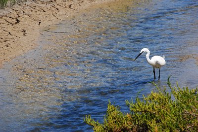
Aigrette garzette - Chloé Scannapiéco - PNR Camargue FaunaThe Little Egret
The Little Egret is one of the most famous birds in the Camargue. White plumage, black legs and yellowish fingers make it easily identifiable. In nuptial plumage, the neck of adults is adorned with two hoopoes about twenty centimeters and their back long silky feathers very thin with separate beards. Today widespread in the southern half of Europe, this species was on the verge of extinction in the early twentieth century, hunted for its feathers that decorated the hats.
Ancien hôpital - Juliette Primpier - PNR Camargue Patrimony and historyThe old hospital
Ernest Solvay was a social precursor, he integrated a system of social security. As a result, workers at Solvay benefited from health and social protection. Ernest Solvay's hygienist project is reflected in the landscape by equipment such as the hospital and bath-showers. A doctor and a midwife were hired. In addition, a pharmacy was developed and social funds were proposed. The social adventure of the Solvay factory is associated with its industrial history.
Exploitation du sel - Julien Faure - PNR Camargue Patrimony and historyThe salt history
The salt exploitation dates back to antiquity but took an industrial turn in the 19th century. with the installation of the Péchiney factory whose first production was that of soda. A supply of sea salt being necessary, Henri Merle, began the creation of the exploitation of Salin-de-Giraud. The development of chlorine and soda requirements led to the growth of the farm. Today, the company that operates the site is the Salins du Midi.

Camelles - Emmanuel Vialet - PNR Camargue Patrimony and historySalt
In Camargue, the salt is very widely present in the soil. The proximity of the sea and the nature of flat and very clay soils favor the extraction of sea salt by evaporation of water. It is cultivated and harvested at the end of the summer on immense expanses, called "salins", under the combined effect of sun and wind. The white gold is then raised in long mounds of ten meters high, called camels, then washed, drained, ground, conditioned, and shipped.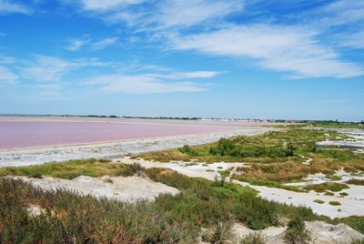
Les salins de Giraud - Chloé Scannapiéco - PNR Camargue PanoramaSalt perspective on salt marshes
A unique point of view on the Giraud salt which covers 6000 ha and produces about 450 000 tons of salt every year. Between June and September, large plots filled with water of a beautiful pearly pink sparkling in the sun appear. The pink colour of the salty table water comes from a microscopic seaweed living in the Mediterranean. On the left, we see the "camels", salt hills of more than 10 m high. The salt of Giraud production is intended for the salting of roads.
Description
From the Tourist Office of Salin-de-Giraud, join the D36 towards Arles, then continue straight for 2 km.
1 - Turn left towards the Vaccarès pond and continue for 2 km. Do not miss the path to the left to go towards the Belugue and continue the path of the Belugue.
2 - Turn right after the stop sign and take the dirt road to the concrete car gauging. Pass the gauging (car over 2 m wide) located in front of the ruins of Tourvieille. Continue on the trail to the red striped barrier. Pass the barrier and walk along the Fangassier and Galabert ponds The route is then only accessible on foot and by bike to the next barrier.
3 - Continue after the second barrier and pass in front of the of the flamingo observatory cabin. Continue straight on the track to the paved road, follow it for 4 km.
4 - Turn right on the D36c towards Saint-Bertrand Mas and Salin-de-Giraud Leave the Saint-Bertrand Mas on the left and stay on the road in the direction of saline-of-Giraud. Turn right and return to Salin-de-Giraud by the main road, the D36.
5 - In Salin-de-Giraud, take the bike path along the D36d on the left and then the road to reach the salt point of view. Then return to the Tourist Office of Salin-de-Giraud by returning on your path.
- Departure : Tourist Office, Salin-de-Giraud
- Arrival : Salin-de-Giraud
- Towns crossed : Arles and Saintes-Maries-de-la-Mer
Forecast
Altimetric profile
Recommandations
Stay alert on the D36, road frequented by cars!
Respect the rules of the road on roads open to public traffic.
Difficult traffic on dirt roads and tracks in case of rain or rising water. Difficult route in case of wind.
Information desks
Domaine de La Palissade
BP 5, 13129 Salin-de-Giraud

OT Salin-de-Giraud
1 Boulevard Pierre Tournayre, 13129 SALIN DE GIRAUD
Transport
Envia transport network : Agglo 10> Arles / Salin-de-Giraud by Gageron and Villeneuve >> www.tout-envia.com; www.pacamobilite.fr
Access and parking
38 km south-east of Arles, by the D570 and the D36.
Parking :
Access
- Emergency number :
- 114
More information
Report a problem or an error
If you have found an error on this page or if you have noticed any problems during your hike, please report them to us here: