
EYGUIERES - The Défends massif in Eyguières
Let yourself be carried away by the typical atmosphere of the Mediterranean garrigue and discover the faunal, floristic and agricultural wealth of the Alpilles. This loop bypasses the massif of Défends and offers outstanding views of the Alpilles.
7 points of interest
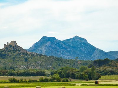
Castellas de Roquemartine et les Opies - Sébastien Couthures  Panorama
View of the Castellas of Roquemartine
Queen Jeanne’s castle and chapel, built between the 11th and the 13th centuries, have had a tumultuous history. This strategic position allowed military and economic control of the Eyguières valley as well as the communication routes to the south and east of the Alpilles, guaranteeing its owner considerable income. The major crossroads have for a long time helped the transhumant herds of the Crau to take the routo des alpages (alpine pasture roads).
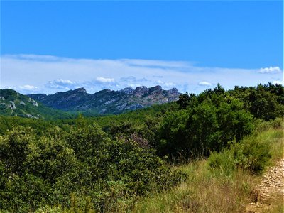
Vue sur les Civadières - ©Rémi Sérange - PNR Alpilles PanoramaView of the top of the Opies
If you look up, you will see the Opies massif. This massif, a bit away from the Alpilles, is characterized by a series of ridges where the highest point is located in the territory of the Park: the Opies, at 498m of altitude. From the lookout tower which symbolizes the summit, you can see up to the Alpine peaks! Nevertheless and despite its imposing presence, this massif is fragile and it is advisable to roam other peaks capable of receiving visitors.
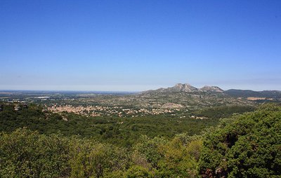
Village d'Eyguières vu du massif du Défends - ©Julie Delbarre - PNR Alpilles PanoramaView over Eyguières
At the junction between the Crau plain ant the lower Durance valley, the village of Eyguières occupies a small valley sheltered by the hills of Mont Menu, Défends and Roquemartine. Since the 11th century, the village has taken advantage of this unique site and its abundance of springs, which were quickly channeled and exploited, to establish itself. Theses resurgences gave the town its name and coat of arms: Eyguières, formerly spelled “Aiguières” come from the Provencal “Eiguiero” and refers to a vessel for holding water. The groundwater of the Defends massif supplies water to all three of the village natural springs: the Gilouse fountain, the Bormes fountain, and the Font Vieille. In the distance, you can perceive Les Opies, the highest point in the Alpilles Mountains, rising to 498m.

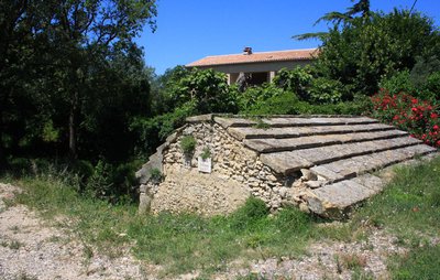
Défends - ©Jason Gaydier - PNRA  Patrimony and history
terminal IGN
Under the Old Regime, a “défends” was an estate reserved for the exclusive use of a lord. All activities (hunting, harvesting, gathering dead wood, or pastures) were prohibited to the population. Numerous lawsuits pitted communities against their lords over the rights to use these lands. In Eyguières, the Count of Sade (a distant relative of the Divine Marquis) had placed the entire mountain range under défends. Until the Revolution, grazing livestock there was therefore prohibited.
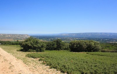
Point de vue depuis le sentier sur les différents massifs - ©Julie Delbarre - PNR Alpilles PanoramaAt the crossing of the massifs
The recognizable silhouette of Mont Ventoux, the “giant of Provence,” marks the horizon. Crowned with white limestone fragments that give it a snowy appearance, it’s the highest point in the Vaucluse Mountains at an altitude of 1,911 m. To its left, in the foreground, the cliffs that close off the Roquemartine plain mark the eastern limit of the Alpilles mountain range. The Luberon mountain range faces them, separated from the Alpilles by the bed of the Durance river.,For centuries, crossing the Durance was made difficult by the river's frequent and formidable floods. One of the only safe passages for people, goods, and livestock to reach Cavaillon, Apt, and beyond to the Alps was a ferry established in the vicinity of Orgon.
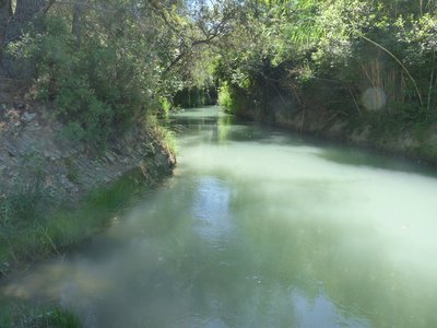
Canal de la Vallée des Baux à Eyguières - ©Jason Gaydier - PNRA  Water and rivers
The Baux valley canal
Water has always been a major concern in the Provence region. With the construction of the Craponne Canal at the end of the 16th century, the silty waters of the Durance River disrupted these arid landscapes. Throughout the 19th century, canals underwent considerable development, and in 1914, the Vallée des Baux Canal enabled the irrigation of land south of the Alpilles. It irrigates around 2,800 hectares of agricultural land: olive groves, vineyards, orchards, cereals, and vegetables
Fontaine Gilouse avant rénovation - ©Julie Delbarre - PNR Alpilles Water and riversFontaine Gilouse
The Gilouse fountain is a spring supplied by a natural resurgence of groundwater stemming from the Défends massif. This fountain was established in 1774. It provides water to a small open-air wash house dating from 1664, which can still be seen today.
Description
At the Gilouse fountain, cross the road and take the DFCI track that climbs opposite the fountain. Follow the red and white markings (GR®).
1 - At the junction, turn left onto the gravel path that descends below, then continue straight ahead at the next crossroads to stay on the GR®.
2 - At the crossroads of the DFCI AL 140 and AL 141 tracks, continue until you reach the departmental signpost. Follow the direction of “Lamanon par les crêtes du Défens.”
3 - At the intersection, follow the GR® to the left, pass the first trail on the right, then turn right at the next intersection and begin the strong ascent.
4 - Shortly after the first pylon, leave the track on the right, following the GR® trail, before rejoining it a little further on and continuing to the right. Near the next pylon, leave the track and take a trail that follows the crest line to the right.
5 - At the junction of tracks AL 142 and AL 143, turn right and follow the path “Eyguières par le chemin du Défends.” Leave the track for a small gravel path marked in yellow that leads off to the right and starts the descent.
6 - Once at the bottom, turn left, go through the barrier and turn right. Continue on this track overlooking the olive groves, ignoring the paths on the right and left.
7 - At the fork that divides the path in two, take the right fork and continue straight ahead until you reach a concrete track. Then turn right up the hill for a few meters before turning left onto the small yellow-marked path that leads into the vegetation. Continue to the D17 without entering private property.
8 - At the paved road, turn right onto the Chemin de la Fontaine Gilouse to return to the parking lot.
- Departure : Gilouse fountain, Eyguières
- Arrival : Gilouse fountain, Eyguières
- Towns crossed : Eyguières and Lamanon
Forecast
Altimetric profile
Recommandations
Small difficult passage after the reference point No.4, at the IGN milestone.
Be careful with the small path after the reference point No.5, very slippery!
Information desks
House of the Alpilles Regional Nature Park
2, boulevard Marceau, 13210 Saint-Rémy-de-Provence
Located in the heart of the city centre of Saint-Rémy-de-Provence, the House of the Alpilles Nature Park welcomes you to its completely renovated premises. This new vibrant place is multifunctional: it accommodates the Park's engineering team but also has a public reception space and showrooms. A true resource centre of the Park's heritage, it aims to support and promote locals, visitors and tourists on all 16 municipalities of the Park.
Open Monday to Friday, from 9 am at 12:30 pm and from 1:30 pm to 5 pm.
Free admission.

Service Info Tourisme
Place de l’ancien Hôtel de Ville, 13430 Eyguières
Transport
Search for the public transport timetables on the website www.lepilote.com in the municipality of Eyguières.
Access and parking
Cross the village of Eyguières towards Sénas. At the last roundabout before leaving the village, turn right on the way to the Gilouse Fountain and continue for 100m.
Parking :
Report a problem or an error
If you have found an error on this page or if you have noticed any problems during your hike, please report them to us here: