Le Mourre Nègre, southern side
« At the bend of the path, after a sharp turn, short of breath, I found myself face to face with a herd of ewes.! I let them quietly go their way towards their sheep pen and I resumed the ascension of a Mourre Nègre playing hard to get… Once at the top, what a reward.! The Alps, the Mont Ventoux, the perched villages and in the distance, even the Mediterranean Sea.! On these ridges, you may no longer know which way to look ! » Marie Grenouilleau, trainee, a master 2 student at the Luberon RNP.
12 points of interest

Affleurement de molasse - ©Stéphane Legal - PNR Luberon  Geology
Tropical sea in Cabrières-d'Aigues
The cliff that dominates the Règue valley is made of limestone. It outcrops westward almost continuously, on nearly 15km until Vaugines, through Cucuron. Geologists have called this geological formation the Molasse de Cucuron. This rock is very rich in sand grains, gravel and fossil remains (scallops, oysters, corals ...). Fossils evidence the presence of a warm sea right here, about 10 million years ago.

Galets perforés par des pholades - ©Stéphane Legal - PNR Luberon GeologyThe Durance river
Many pebbles cover the ground. Some are black, green, red. They share the same composition with some rocks in the Alps. They were transported to Cabrières by powerful streams: the ancestor of the Durance, 10 million years ago!
Some pebbles have small holes. This is the result from the activity of marine molluscs, the Angelwings (Piddocks), which dig a hole in the rock to live in it. These bivalves live today in coastal areas.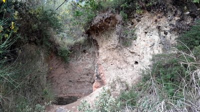
Four à chaud - ©Eric Garnier - PNR Luberon GeologyHeating limestone to make whitewash.
On the roadside, the bank is hollowed out by a hole with reddened walls at the top and varnished in the lower part. This is a lime kiln which has no doubt been used for local purposes. We don't know how old it is. Several days were needed to dig this type of kiln, build a corbel arch just like the bories, and place the limestone blocks. Cooking it, around 1000 °C, required constant monitoring for about 4 days.

Anticlinal du sud Luberon - ©Eric Garnier - PNR Luberon GeologyThe Luberon: a mountain with a tender heart
On the right, a track lets you follow a little escarpment which highlights the rift in the passage and marks the northern border of a line of hills. The limestone that make up these hills is as old as those of the Luberon ridges. In between, the marly rocks are more recent. These information help in the outlining of the geometry of the Luberon: an asymmetrical arch-shaped bend (anticlinal). The heart of the massive, much more gentle, has been hollowed out by erosion and forms a valley.

Patou - ©DR-Animalaxy  Fauna
FaunaThe Patou (Pyrenean Mountain Dog), a faithful keeper!
In these grazing areas, you can come across a patou between January and April. This big white dog is an impressive keeper. His task is not the easiest: he has to protect his flock against wolves. The patou takes his role very seriously, so no threats or shouts, keep your dogs on a leash and do not dare cross his flock! Go around it and walk quietly, the patou will sniff you and go back quietly to his task.
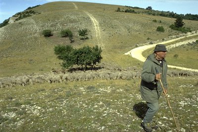
Berger et son troupeau sur le Grand Luberon - ©Hervé Vincent  Elevage et pastoralisme
Sheeps and shepherds, keepers of the peaks!
In May and June, you will encounter sheep grazing. Thanks to them, the exceptional biodiversity of the peaks is maintained. Without grazing, you wouldn't be able to see as many insects, birds and spring flowers. Sheeps prefer, because they choose them, rare plants and limit the closing of the lawns by the forest. Farmers are supported in their work by the Park, the ONF (National Forest Offices) and pastoralists.

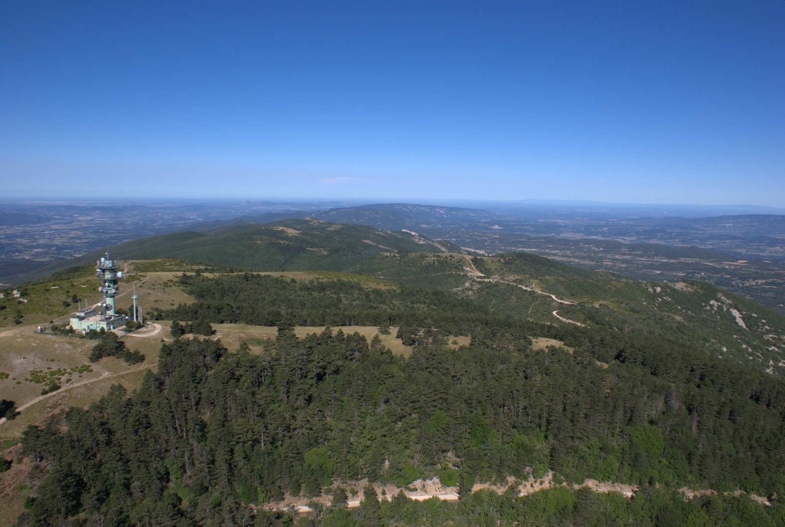
Sommet du Mourre Nègre (1125 m) - ©Eric Garnier - PNR Luberon  Panorama
Valleys and open spaces
The Luberon is visible from everywhere and very present in the landscape. From the peaks, wide panoramas are also available to us: Our eyes travel across the southern massifs (Alpilles, Sainte-Baume...) and northern massif (Mont Ventoux). But this landscape is also characterized by the very intimate micro atmospheres like the wooded valleys below and the surrounding rocky valleys. At our feet, the mark of man is discreet and increasingly present beyond the Durance.

Vue aérienne du Mourre Nègre - ©Stéphane Legal - PNR Luberon GeologyI am several million years old!
The Luberon was not built in a day, far from it! Its birth is connected to the birth of the Pyrénées, about 40 million years ago. This is also the case of Provencal Alpilles, Ste-Victoire, Ste-Baume massifs, etc. all oriented east-west. With the formation of the Alps, it has lived for 20 million years, several episodes of deformation leading to its current structure: a wide asymmetrical arch-shaped bend (anticlinal) overlapping the south.

Ambiance des crêtes - ©Eric Garnier - PNR Luberon PanoramaFrom the summit of the Grand Luberon
Mourre Negro, black muzzle in Provence, culminates at 1,125m and overlooks the mountains of the Grand and Petit Luberon. The summit reveals a splendid panorama at 360°.. On the north side, behind the basin of Apt and plateaus of the mountains of Vaucluse, Mont Ventoux, the Lure mountain and, in the background, the snowy peaks of the Ecrins massif can be seen. On the south side, beyond the plain of the Durance, we can observe Ste-Baume, the Sainte-Victoire, Etang de Berre, Camargue, Alpilles,...

Orchidée sur les crêtes - Françoise Delville - PNR Luberon  Flora
FloraThe grass at the summit
These grasslands of great biological wealth are the result of the combined effects of the altitude, wind exposure and a traditional use by shepherds. Apart from common species, the lawns are home to rare plant species (more than fifty). This plant life diversity provides shelter and abundant food for many herbivorous insects (over 265 species). So, many birds mainly appreciate these apical lawns.

Circaète Jean-le-Blanc avec un serpent dans le bec - Jean-Pierre Malafosse - PN Cévennes FaunaReptile eaters
The Short-toed Snake Eagle is a migratory raptor that lives in the region from March to October. Brown but with a white plumage, it is recognizable by its yellow eyes and its big round head. Its speciality? Its diet is mainly composed of reptiles: snakes, lizards or vipers (which it is not immune against the poison). It can hunt for more than 10km from its zone and prefers open and sunny areas like the apical lawns or scrublands.

Lucane cerf-volant sur buis - ©Laurent Michel - PNR Luberon FaunaWood eating bugs
In the oak grove, many wood-boring insects (that feed on wood) thrive. Essentially beetles of the Cerambycidae or longhorn family are found. It is the larvae of these insects that eat wood and can stay up to 3 years in the warmth of the wood before metamorphosing to reach adulthood.
Description
From the town hall, go up the street on the right, then take a left at the fountain. Turn right until the crossroads "Cime de Vière". Take the track to the massif along the farmlands. 350m after a left turn, reach a collar and continue straight onto the track.
1 - At the crossroads"The Couleron" (point 586), leave the geological trail on the right and climb the left track (GR.). After a series of winding paths, you finally reach the highest ridges.
2 - At the crossroads "La Basse de Cabrières", take a left and reach the antenna, the highest point of the Grand Luberon. At the top of the Mourre Nègre (1 125m), turn around and return to point 2. From here, continue straight on the ridges and cross five hills.
3 - At the crossroads "Gros Collet", leave the GR and switch right on the trail (RP). 450m down, continue straight and hurtle down the slope under the forest cover until the Draille de Roche (point 609).
4 - Turn right, move forward 10m and turn left just after the tank. Down the trail, go back on the track and continue down to reach an asphalt road. Continue straight for 1.5km leaving the geological trail half-way, on the right.
5 - 20m before the crossroads "Les Vaucèdes", turn right and go down the trail to the creek. Follow the riverbed to the right for 100m and climb the steep path on the left. Go around the field and continue right up the track. Get to the road and continue straight, then head right back down to the left, at the starting point.
- Departure : Facing the town hall of Cabrières d'Aigues
- Arrival : Town hall of Cabrières d'Aigues
- Towns crossed : Cabrières-d'Aigues, Castellet-en-Luberon, Auribeau, Saint-Martin-de-Castillon, and La Motte-d'Aigues
Forecast
Altimetric profile
Recommandations
- After point 1: steep climb to the ridges.
- Between points 3 and 4: Caution with your ankles in the descent.
- After point 5: tricky passage of the ravine after a violent storm.
Information desks

Luberon UNESCO Global Geopark
60, place Jean Jaurès, 84400 Apt

House of the Luberon Regional Nature Park
60, place Jean Jaurès, 84400 Apt
In the heart the old town centre of Apt, the House of the Luberon Regional Nature Park welcomes you in a town house of the 18th century. The permanent exhibition of the geology museum has a rich collection of fossils evidencing the geological history of the Luberon.
On sale at the shop: books, maps, guidebooks, games, posters...
Open Monday to Friday from 8:30 am to 12:00 pm and from 1:30 pm to 6 pm (and on Saturday, depending on the program). Free admission.

OTI Luberon Sud Tourisme
128 chemins des vieilles vignes (siège administratif), 84240 La Tour d'Aigues
Access and parking
At 11km from Pertuis (A51), on the D9.
Parking :
Access
- Emergency number :
- 114
Source

Report a problem or an error
If you have found an error on this page or if you have noticed any problems during your hike, please report them to us here: