Col Girardin
Guarded by the peak of Mount Fonte Sancte, the highest point of Queyras, Lake Sainte Anne, very accessible, offers a high mountain atmosphere. Steep walls and rock glaciers adorn this remarkable atmosphere.
8 points of interest
Les sommets du lac Sainte Anne - Benjamin Musella - PNR Queyras  Peak
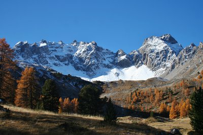
PeakThe summits of Lake Sainte Anne
In the foreground is the end of the sloping ledge of the Adoux sheep pen. We can make out, in the middle distance, a platform where the Lake Saint Anne is located. In the background, the Pics des Heuvières to the right and the Pic de la Font Sancte to the left overlook the lake.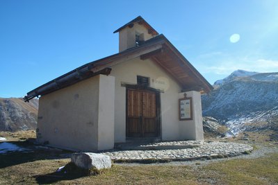
Chapelle Sainte Anne - Benjamin Musella - PNR Queyras  Patrimony and history
Sainte Anne Chapel
The Sainte Anne Chapel faces the lake with the same name. They are also known as the Doux (spring). Pilgrims have been going to the chapel for a long time. The first writing dates back to July 9, 1699. Il records the offerings made to stop the drought. The chapel was destroyed in the winter of 1918-1919 and rebuilt. Its blessing was held on July 26, 1921 in front of 500 people.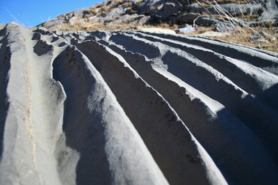
Cannelures - Benjamin Musella - PNR Queyras  Geology
Fluting
These erosions in the form of parallel channels are created by the action of water. The water spread out on a surface remains more or less compact as a whole. It will not have a uniform spreading but will form "spots" and remain as a whole as much as possible. On a sloping surface, the water keeps this consistency and flows following the lines. It will gradually dig the limestone along its path. Once the fluting process begins to dig through, the water becomes trapped in this micro furrow and continues its erosion.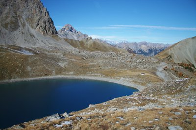
Lac Sainte Anne - Benjamin Musella - PNR Queyras GeologySainte Anne Lake
Mountain lakes are the result of the action and the moving of glaciers. By moving, the glacier digs the ground. When it comes across a hard rock, the glacier bypasses it. It can go over it and dig through once it passes the obstacle. At the rear, the glacier leaves in front of the hard rocks encountered previously, a basin closed in front by the mountain glacier and in the back by the mountain. These are the glacial lakes. Other glacial lakes exist such as moraines. But this is another story.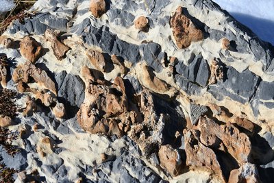
Conglomérat - Benjamin Musella - PNR Queyras GeologyConglomerate
The conglomerates are composed of detrital rocks bound by a natural cement. They are composed of different rocks fractured by erosion. These rocks are generally sedimentary (as here) but can also be of volcanic origin. There are various conglomerates. Here its a breach, the rocks are angular. If the stones are pebbles, it is called "pouding" and if angular stones and pebbles are mixed, it is called "tillite".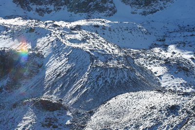
Benjamin Musella - PNR Queyras GeologyRock glacier
Rock glaciers are composed of ice mixed with rock debris. They move very slowly. For example, the rock glacier of St Anne moves about 0.34m per year. We can distinguish 3 layers which form the rock glaciers. The top layer is formed of rocky debris, free of ice. This layer, in direct contact with the air, freezes in winter and melts in summer. The core layer is a mixture of ice and debris. The last layer is the rock debris buried by the moving glacier. Here, the rock glacier is covered with the first snowfall.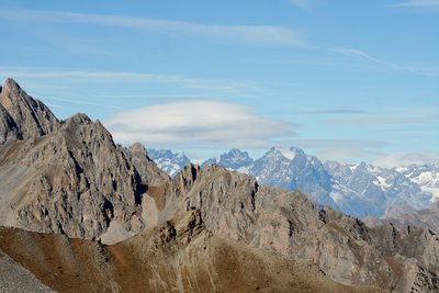
Altocumulus lenticularis - Benjamin Musella - PNR Queyras  Panorama
Altocumulus lenticularis
Shaped like a dome, the Altocumulus lenticularis or lenticular cloud appears to be still. In reality, they are indicative of unstable air. Bumping into mountainous areas, a large mass of air rises and causes a partial condensation of the water vapour contained therein. Thus forming a cloud. Once the obstacle is passed, the cloud dissolves. It is therefore in constant movement although it seems still.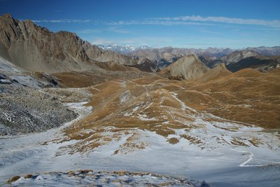
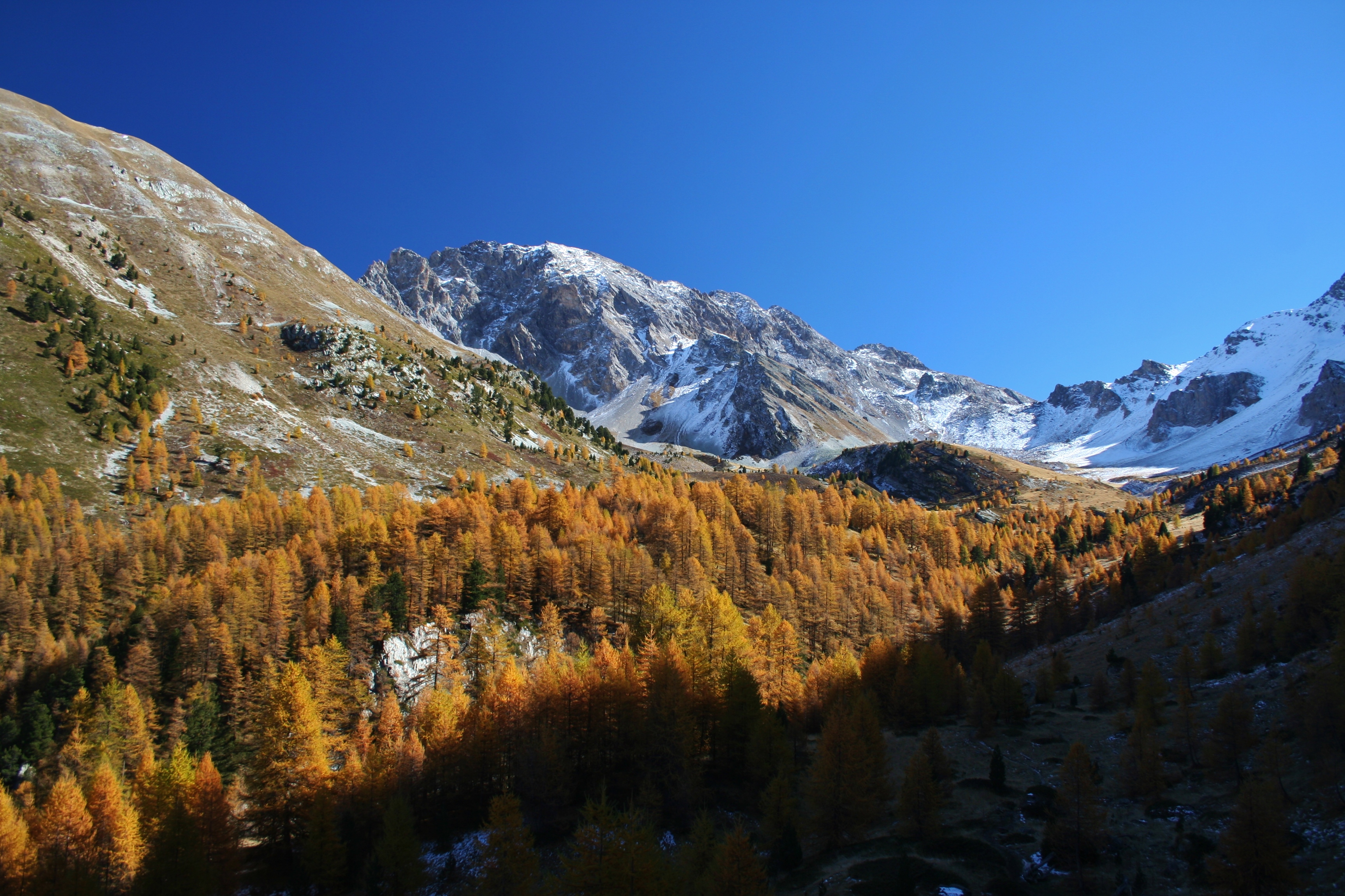
Point de vue en montant au col Girardin - Benjamin Musella - PNR Queyras PanoramaView going up the Col Girardin
Here, a view of the slope of the Col Girardin at the end of autumn. Before the Sainte Anne valley, under the first ledge, are the lake and the chapel. In the background on the left are the snow-covered massifs of Ecrins.
Description
From the car park, go down and turn left, cross a bridge and turn left again. Get on the wide path on the left bank of the stream of the Col du Tronchet. As the trail refines, cross the stream by a bridge and take on a rise in curves.
1 - At point Costes du Col Tronchet (2 164m), turn right on a path that remains levelled, cross the stream again by a wooden bridge and follow the descending false flat. Go around a large mound, and continue to the left.
2 - Exit the forest on a plateau, go around it by the left and follow the last climb to the lake Sainte Anne.
3 - Reach to the lake and turn left on the GR. Take a short climb and continue on the ascending false flat. At the foot of the last climb, go up to the right in the shale until Col Girardin. The same route is used for the return.
- Departure : Fond de Chaurionde
- Arrival : Fond de Chaurionde
- Towns crossed : Ceillac and Saint-Paul-sur-Ubaye
Forecast
Altimetric profile
Information desks
House of the Queyras Regional Nature Park
3580 Route de l’Izoard, 05350 Arvieux
The House of the Queyras Regional Nature Park is closed to the public.
OTI du Guillestrois et du Queyras
Maison du Tourisme du Queyras, 05350 Château-Ville-Vieille
Transport
05 Voyageur: 04 92 502 505 Tourist Office of Queyras: 04 92 46 76 18
Access and parking
Pass Ceillac and continue until the bottom of the valley.
Report a problem or an error
If you have found an error on this page or if you have noticed any problems during your hike, please report them to us here: