The Plain (forest)
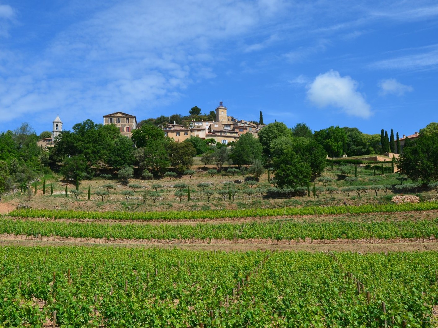
A family hike that allows you to discover the charm of the village of Moissac, which has kept its Provençal charm, and its peak of 630m will make you reach for the sky to admire a breathtaking view of the Esterel in the Sainte Baume passing by the Massif des Maures.
6 points of interest
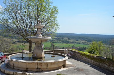
La Fontaine - Stefano Blanc PNR Verdon  Patrimony and history
The Fountain
In the middle of the 19th century, Moissac-Bellevue had a total of 260 inhabitants, among which 200 lived in the heart of the village. But there was no water and the residents had to get water at the "font vièio" located at the bottom of the village, 600m, and then at the "font novo" located above, but the river bed was dry in summer. In 1860, the municipality decided to purchase a source close to Vérignon, on the territory of the town of Aups 11km from the village, and the construction of a fountain in the village. The pipe work and construction of the fountain were completed in 1875. The amount of the building works ruined the municipal finances, and the town council had to sell the vast forest of Pelenc to the State to cover the debts.
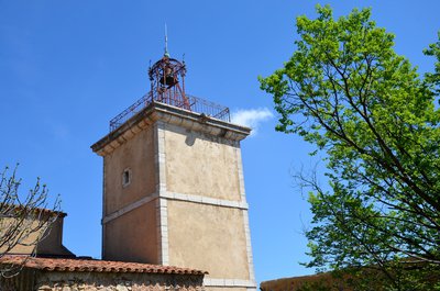
La Tour de l'Horloge - Stefano Blanc PNR Verdon Patrimony and historyThe Clock Tower
Initially planned next to the church, to serve both as a steeple and a clock, the tower was finally built in the village in 1816. The bell tower was built by an ironworker from Draguignan Mr. Ollevary. Until the late 19th century, it was a tradition to welcome the "vagrants and poor wretches" in the villages. They were lodged in the tower and received food. Following complaints of the inhabitants, this accommodation was abolished in 1904.
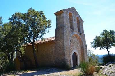
Notre Dame de la Roque - Stefano Blanc PNR Verdon Patrimony and historyNotre Dame de la Roque
Overlooking the valley, the chapel of Romanesque style, offers a unique perspective. The place name "la Roque" evokes the pitched position of the building sitting directly on the rock. The chapel stands out in the distance by an imposing wall and steeple. It represents a covered stone bedside whose origins may go back to the 13th century, but it also displays traces of many changes. On the site, there are numerous remains of medieval houses.
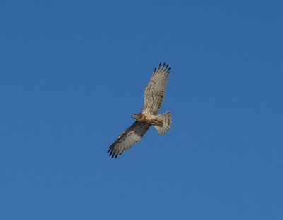
Circaète Jean-le-blanc - Stefano Blanc - PNR Verdon  Fauna
FaunaThe reptile hunter
The short-toed eagle is one of the most common raptors and easier to see in our region. This white eagle dark throat consumes mainly reptiles, he hunts hovering. Migratory he attended the March region in September and are installed nest on a pine tree in a quiet valley. The single egg is laid between late March and mid-April and the chick flew four months later. As for the golden eagle, intensive monitoring concerns the short-toed eagle.
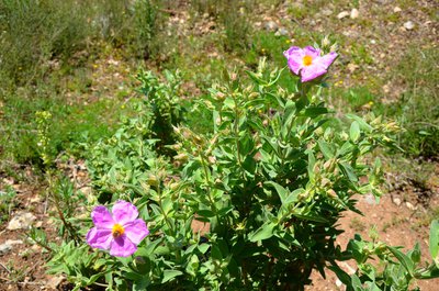
Ciste cotonneux - Stefano Blanc PNR Verdon  Flora
FloraThe Cottony Rockrose
The Cottony Rockrose (Cistus albidus) is shrub characteristic of the ‘garrigue’, although adapted to arid conditions and limestone soils. It can be found in the hills of the Haut Var and flowering starts in April .
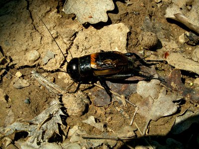
Le Grillon Provençal - Stefano Blanc PNR Verdon FaunaA true Provençal singer
The Provencal cricket is active mostly at night and only found around the Mediterranean. Males only begin to stridulate late after dusk throughout the summer, a little earlier from mid-September, especially if the weather is gray. During the second half of the season, we can catch them by surprise “sunbathing” and enjoying hot temperatures. Even in the dark night, it quickly spots a human approach and stops singing at a safe distance.
Description
Pass the town hall and go up the road to the oratory up to the plateau. After passing the St. Eloi oratory, cross the main road and follow slightly across the Chemin de Vérignon.
1- Take an immediate left to the Ravas track. The track travels in a forest of pines and oaks. Leave behind a path on the right and at 1.3km, reach a cistern and a crossroads of 6 tracks.
2 - Continue across on the "Pont Romain" track. Cross the Plaine forest and 900m further, reach a track coming from the right, then 300m further, take a small path to the right between the oaks just after the tank.
3- From the passing, come out on the other side of the hill. Take the right path. Continue on the route amidst the oak trees, past a pool and come out "Pont Romain" track.
4- Go across and reach after 300m the crossroads of 6 tracks. Go back to the village by the left path taken to go.
- Departure : At the village, in front of the fountain
- Arrival : At the village, in front of the fountain
- Towns crossed : Moissac-Bellevue
Forecast
Altimetric profile
Recommandations
Avoid high summer temperatures, leave early. We recommend: 2L of water per person, a hat and proper hiking shoes. In summer time, find out whether the forests are open to the public (fire risk) by calling 04 89 96 43 43 (answering machine of the Direction Départementale des Territoires et de la Mer) or by visiting the website of the Prefecture by clicking the tab "For more information".
Information desks
House of the Verdon Regional Nature Park
Domaine de Valx, 04360 Moustiers-Sainte-Marie
House of the Verdon Regional Nature Park

OT Aups
Place Martin Bidouré , 83630 Aups
Access and parking
Take the D9 from Aups or the D30 from Régusse
More information
Report a problem or an error
If you have found an error on this page or if you have noticed any problems during your hike, please report them to us here: