The balconies of Aiguebrun by mountain bike
« A biking trail suitable for first laps with the family! No real technical difficulty, a total distance and reasonable gradients, two steep but short paved climbs and a loop hole halfway. This pleasant walk also offers beautiful views of the Aiguebrun valley, the castle and Fort de Buoux». Eric Garnier, Head of Studies for outdoor sports at the Luberon RNP.
8 points of interest
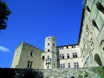
Château de Buoux - ©Jérémie Haye - PNR Luberon  Patrimony and history
The Castle of the environment
The Château de Buoux, of medieval origin (12th and 13th centuries), is now an educational centre of the Luberon Regional Nature Park.
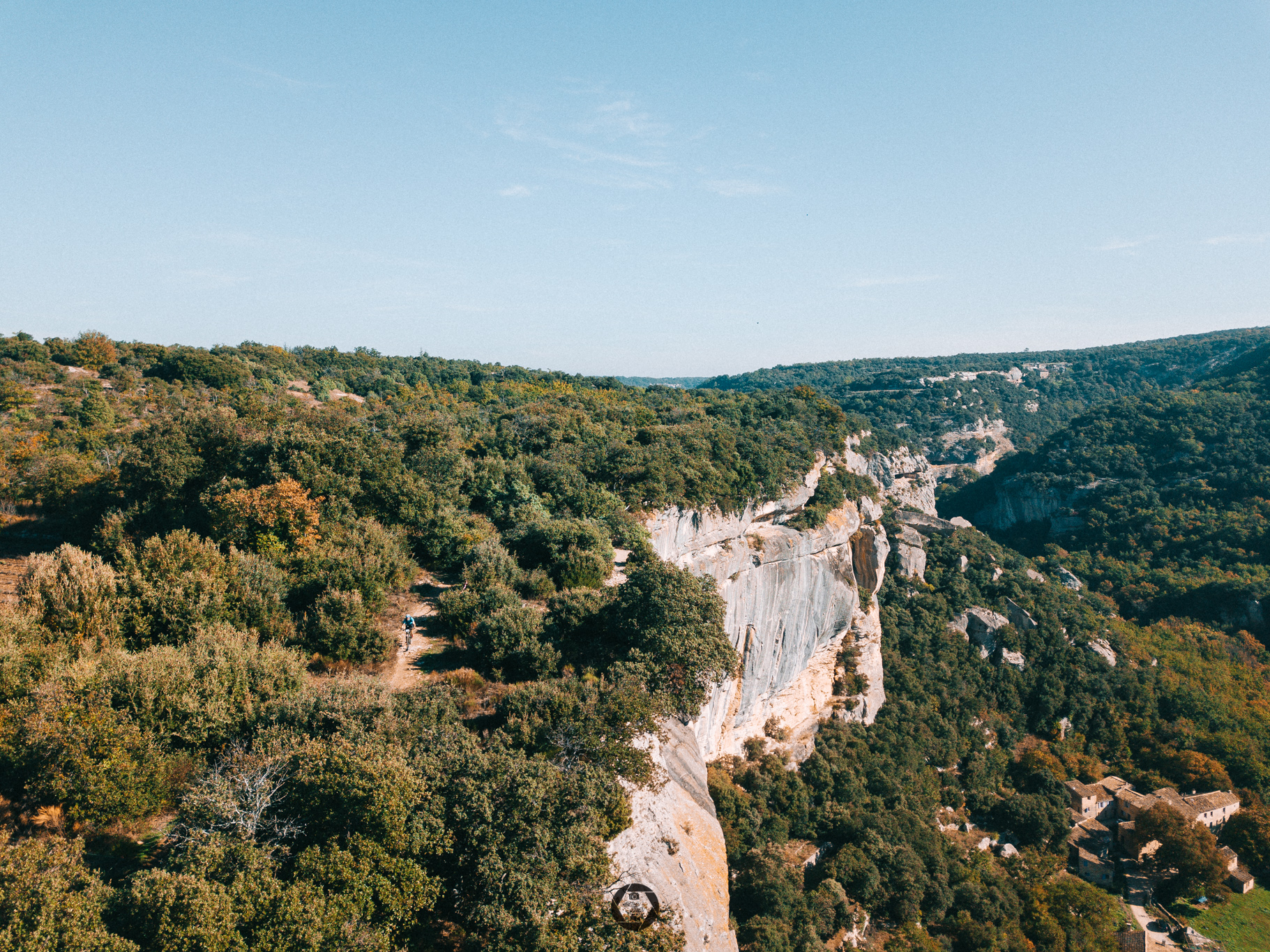
L'Aiguebrun vu du dessus - ©Pierre Duret  Geology
Aiguebrun, so irrational!
The Aiguebrun takes its source of the north side of the Luberon to flow into the Durance on the south side! Three explanations to this illogical route: 1) The weakened zone, faulted and collapsed between Grand and Petit Luberon will collect run-off waters to the south. 2) The Luberon mountain, by rising, caused the depression of the river that was already there (antecedence phenomenon). 3) The drying up of the Mediterranean Sea, about 6 million years ago, will further accentuate this depression.
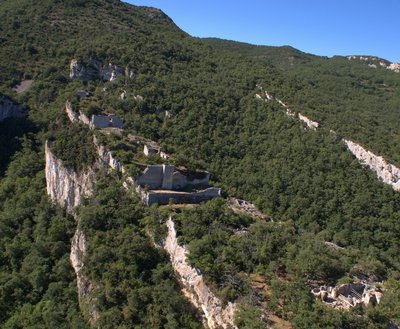
Fort de Buoux - ©Stéphane Legal - PNR Luberon Patrimony and historyThe fort of Buoux
Across, on its rocky spur, the Fort of Buoux has been, for a very long time, the cornerstone of the defence system of all communication through the Luberon. Occupied since prehistoric times, it was fortified in the Middle Ages. Never stormed, it sheltered a garrison and civilians until it was dismantled on order of Louis XIV in 1660, to prevent it from falling completely into the hands of Protestants during the religious wars.
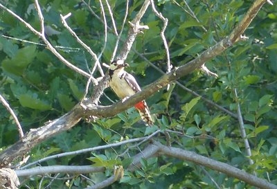
Pic épeiche - ©Laurent Michel - PNR Luberon  Fauna
FaunaTree sheds
With their straight bills, woodpeckers drill through tree barks for nesting purposes or for extracting wood-eating insects (woodborers). In the Luberon, the Great Spotted Woodpecker (black, white with red dots) mixes with the Lesser Spotted Woodpecker (smaller with less red), the European green woodpecker and the Black Woodpecker (rarer, resembles a crow with a red cap). True social housings for insects and bats, these older trees host a multitude of inhabitants in woodpecker holes, the cracks of branches, under the ivy...
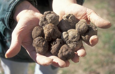
Le fameux "diamant noir" - ©PNR Luberon  Produits du terroir
Truffle in the Luberon
Truffle, "Rabasso" in Provençal, is a fungus that lives on the roots of holm oaks, white oaks but also Aleppo pines... It was a farmer from Saint Saturnin-les-Apt, not far from there, who started the cultivation of truffles by transplanting oak trees known to host truffles in their root system. In winter, truffle hunters and their dog go out in search of the famous "black diamond".». The Vaucluse department is all the same the first French producer and Provence produces more than three-quarters of the national production.

Lavandin du plateau des Claparèdes - ©PNR Luberon  Flora
FloraLavender or lavandin?
Spike Lavender (commonly known as French Lavender) (Lavandula latifolia), with broad white leaves, is a Mediterranean plant. The English lavender (Lavandula angustifolia) with narrow leaves, is more of a mountainous plant (up to 1500m). Although the English lavender is sometimes cultivated in the mountains, it is usually the Lavandin, a hybrid of the two species and more productive, that we see in the fields. Warning, these crops are the result of hard farm work, please do not pick!
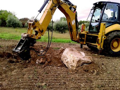
Extraction de pierres - ©Magali Amir Patrimony and historyStones, a true nightmare for farmers!
The small stone huts or bories you see everywhere in the Luberon were built with stones extracted from the fields by the farmers at the time. Today it is still the same problem for farmers of the Luberon, who have to clear their fields of stones several times a year. And even if the sale of stones allows them to earn some money, these stones are a scourge for agricultural equipment, breakage and wear being common.!
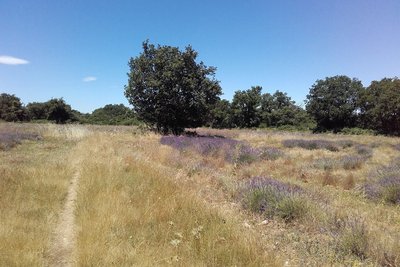
Forêt, pelouse et culture sèche des Claparèdes - ©Eric Garnier - PNR Luberon  Elevage et pastoralisme
Long live the diversity, long live Life!
Dedicated to a traditional agro-sylvo-pastoral system, the Claparèdes plateau is divided between forests, lawns and dry crops, but also groves surrounded by hedges of old trees, including almond trees and mulberries, witnesses of a past culture. The interface and transition zones between all these ecosystems (ecotonal zones) are very favorable to a diversified fauna: birds such as the lark lulu and the sparrow zizi, but also reptiles such as the grass snake, the worm and the ocellated lizard.
Description
From the car park at the northern entrance of the village, go right on D113 and turn left. Outside the town hall, turn right and climb the steep narrow road. Pass a hairpin turn and reach the plateau. In front of the Sainte-Marie chapel adjoining the cemetery, continue on the track to the right (GR®)). After a large field, take a quick left and hurtle down the slope to the farm of Jas (be careful)!). Turn left along the small road, go through the farm and continue for 300m.
1 - At the crossroads ''Petit Auron'', follow the road to the left, cross the bridge and turn left on the path that accesses the Château de l'Environnement. When arriving at the first buildings, turn right and walk the dirt road. At the next intersection (cross), continue straight on the shaded path. Continue the Chemin des Escoufines until Buoux by going around the hill.
2 - Coming out on the D113, take the road across over 30m and at the corner of the inn, go down the path to the right. Come out on the D113 (traffic!), cross the bridge and go left until the hamlet of Deyme. Continue on the dirt road, then rise slowly towards the plateau.
3 - At the crossroads ''Les Ramades'', continue straight first, and after a round trip of 300m, it's possible to reach the beautiful view of the cliff edge. Pass along the truffle fields, turn left in front of a house and 200m further, take the right track. At the crossroads ''Chante Duc'', turn left, hurtle down the 3 hairpin turns of the small road and reach Buoux nestled a little lower.
- Departure : Car park of the village, Buoux
- Arrival : Car park of the village, Buoux
- Towns crossed : Buoux, Apt, and Saignon
Forecast
Altimetric profile
Recommandations
- Après le point 2 : PRUDENCE dans la partie la plus technique du circuit ! La section amont de la descente ravinée par les orages est caillouteuse et jonchée de racines, puis la section aval, plus roulante, est agrémentée de deux marches qu'il convient de négocier avec sagesse. # VARIANTE : possibilité d'éviter cette descente technique de la Chapelle Sainte-Marie, en dévalant directement du point 2 au point 4 par la petite route revêtue qui plonge sur le village de Buoux.
- Point 3 : ATTENTION ZONE PASTORALE à proximité et alentours de la ferme du Jas. En présence de chiens de protection venus à ma rencontre, je ne les caresse pas ni ne les menace. Je m'arrête, puis j'attends patiemment la fin du ''contrôle'' avant de reprendre calmement mon chemin en contournant le plus possible le troupeau. De préférence, ne pas emmener son chien et, sinon, bien le tenir en laisse.
- ATTENTION : bien maîtriser sa vitesse en descente ; vous n'êtes pas seul sur ces sentiers !
- Vigilance aux carrefours pour bien suivre votre itinéraire, car le circuit VTT balisé n°60 au départ d'Apt, emprunte une grande partie également de ce circuit VTT n°59 (+ d'info sur l'espace VTT-FFC Provence Luberon Lure).
Information desks

House of the Luberon Regional Nature Park
60, place Jean Jaurès, 84400 Apt
In the heart the old town centre of Apt, the House of the Luberon Regional Nature Park welcomes you in a town house of the 18th century. The permanent exhibition of the geology museum has a rich collection of fossils evidencing the geological history of the Luberon.
On sale at the shop: books, maps, guidebooks, games, posters...
Open Monday to Friday from 8:30 am to 12:00 pm and from 1:30 pm to 6 pm (and on Saturday, depending on the program). Free admission.

OTI Pays d’Apt Luberon
788 avenue Victor Hugo, 84400 Apt
Du 1er avril au 30 septembre
Ouvert du lundi au samedi de 9h30 à 12h30 et de 14h à 18h.
Juillet et août : Ouvert dimanche et jours fériés de 9h30 à 12h30
Du 1er octobre au 31 mars
Ouvert du lundi au mardi et du jeudi au samedi de 9h30 à 12h30 et de 14h à 18h.
Fermé le mercredi, dimanche et jours fériés.
Access and parking
At 8km south of Apt by the D113 and 12km north of Lourmarin by the D943 and D113.
Parking :
Report a problem or an error
If you have found an error on this page or if you have noticed any problems during your hike, please report them to us here: