The Villars secrets
It is thanks to the work of the inhabitants and volunteer hikers of Villars that some old trail sections have been recently developed. Their combination allows a mischievous route whichgoes through the ochre massif of La Bruyère and then progresses at the foot of the Monts-de-Vaucluse. The contrast is striking! So much wealth in such few steps ... Eric Garnier, Head of Studies for outdoor sports at the Luberon RNP.
11 points of interest
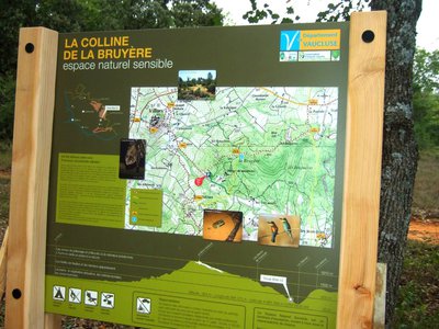
Panneau d'accueil - ©Eric Garnier - PNR Luberon  Flora
FloraENS de La Bruyère
The hill of La Bruyère received the departmental label sensitive natural area (SNA) in 2005. In this context, several plots were purchased by the Luberon Regional Park and the Conservatory of natural areas in Provence-Alpes-Côte d'Azur, in a natural heritage preservation objective. These courses are open to the public only on marked trails and within siliceous preservation of this unique island.
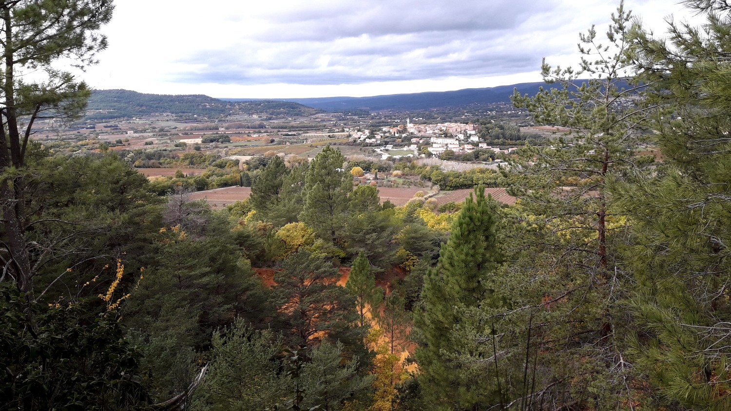
Vue sur Villars - ©Eric Garnier - PNR Luberon  Panorama
This path is of gold, ochre and vermilion ...
This route, This route, away from the Calavon, flowing between the massifs of the Monts-de-Vaucluse to the north and Luberon to the south, enters the wooded hill of La Bruyère rising above this agricultural valley dominated by vineyards. It includes ochreous soils and cliffs quite colourful, hidden in part by a woodland takeover. This vegetation is used to sandy soils which are a minority in this limestone Provence.
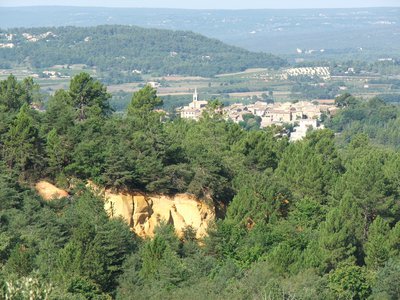
Front de taille ocrier érodé - ©Eric Garnier - PNR Luberon FloraLa Bruyère hill
Like a siliceous island in the middle of a limestone ocean, the hill of La Bruyère (listed and labelled as an environmentally sensitive area) contains a flock of siliceous (silica-loving), acid-loving (likes acid soils) and psammophile (preferring sand) plants. You can come across many species of amphibians (like the Western Spadefoot), birds (such as the European Bee-eater) and bats (like the Greater or the Lesser Horseshoe Bat, the Common Bent-wing Bat).
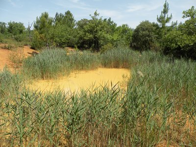
La mare au printemps - ©David Tatin  Fauna
FaunaTrou des Américains pond
This wetland is rooted in the ochre activity of the site and served to store the water used for washing the ochre. This is one of the best preserved ponds of the Luberon Regional Nature Park which is a part of the known breeding sites of Western Spadefoot (or Spanish Spadefoot Toad). This rare and vulnerable species in France is considered near threatened globally. With "spades" in its hind feet, it hides in the sand until it rains!
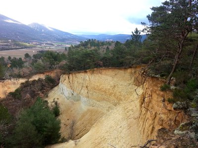
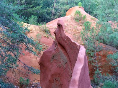
Front d'éboulement - ©Eric Garnier - PNR Luberon  Patrimony and history
Landslide danger!
As holed as cheese, the hill of La Bruyère is pierced with ancient galleries dug by hand. It was an important place for the extraction of ochre. Then, a number of them were transformed into mushroom growing areas. Today, there is no longer human activity. Some have become refuges for large colonies of bats. It is strictly forbidden to enter the galleries (private property), due to frequent landslides and to avoid dramatic disturbance of bats.
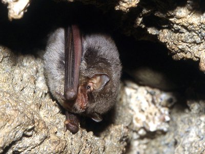
Minioptère de Schreibers - ©DR FaunaThe Common Bent-wing Bat
The hill of La Bruyère hosts the largest transit site of Common Bent-wing Bats in the Luberon. This bat feeds on moths. Very sociable, it settles in clusters in ochre galleries. Its protection is primarily based on tranquillity, especially since the closing of holes with grids is harmful to the Common Bent-wing Bat, because its flight, hard to manoeuvre, does not allow it to move easily between the bars.
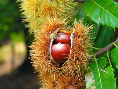
Chataîgne dans sa bogue - ©DR FloraChestnut from acid soils
A small island in the middle of the limestone mountains of Luberon and the Monts-de-Vaucluse, the ochres are home to species of trees that do not grow in limestone. Thus, the chestnut enjoys this ground as it enjoys the sandy soil in the Var department further to the south.
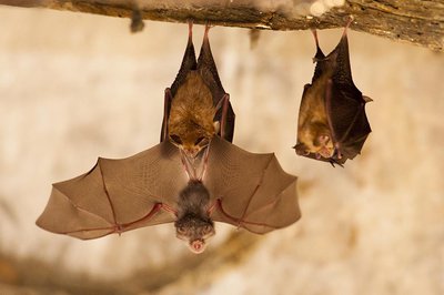
Jeune petit rhinolophe - ©DR-Tanguy Stoeckle FaunaLesser Horseshoe Bat
A true little fur ball, this bat weighs only 2 to 5g. The species has a distinctive horseshoe-shaped nose. When roosting and hibernating, the Lesser Horseshoe Bats hang free and wrap their wings completely around their bodies, resembling a pear hanging free. In winter, it occupies ochre galleries. In summer, the females use the huts as maternity wards. Be careful not to disturb them! It is strictly forbidden to enter the galleries and huts (private property), due to frequent landslides and to avoid dramatic disturbance of bats.
Cabanon refuge chauve-souris - ©Eric Garnier - PNR Luberon FaunaA hut as a maternity ward
In the fields nearby, huts were built to provide shelter and storage. Today abandoned or restored, they are privileged and coveted places by female bats. A true maternity ward, these huts, heated by the sun, are suitable places for birthing and nursing the young.It is strictly forbidden to enter the huts (private property) to avoid dramatic disturbance of bats.
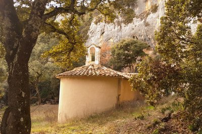
Chapelle Saint-Pierre de Bagnols - ©Eric Garnier - PNR Luberon Patrimony and historyThe Saint-Pierre de Bagnols chapel
The present chapel was rebuilt in the 18th century, after shepherds noticed construction marks leading to the excavations. In the nave, three limestone plates carry the Gallo-Roman inscriptions dating from the 1st century and another medieval inscription of the 11th century. At the time on the site, the Gallo-Romans worshipped Sylvanus (roman tutelary deity). In the Middle Ages, this chapel was erected, built by the Black Monks of Villeneuve, forest settlers.
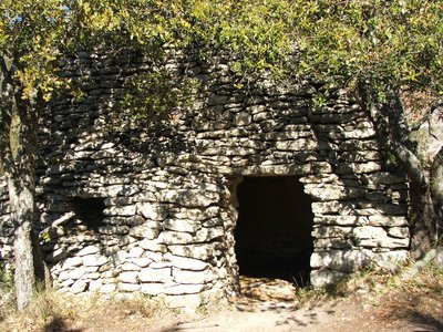
Borie - Eric Garnier - PNR Luberon Patrimony and historyDry stone, stories of mankind
On Monts-de-Vaucluse, they can't be missed! Small walls, pens, retaining walls for terrace fields, or bories They are everywhere.! The construction of these small dry stone structures began when man had to clear his land of stones in order to cultivate it. So what to do with this excess of stones. ? From there came the idea to pile them up in order to build pens, tame slopes or make shelters for men and tools.
Description
Opposite the town hall, turn right towards Rustrel. When at the village hall, dive right onto a path that goes into the housing estate boundary (fence). Turn left onthe road, cross La Riaille and at the intersection ''Clastre'', continue straight. 500m further, take the left path (GR®) entering the classified massive and an ?environmentally sensitive area (ESA). Pass two corners and rise to the left at the top of the hill.
1 - At the crossroads"Trou des Américains" visit the pond 100m to the right and back to point 1. Continue on the right trail (GR®and travel through all the ochre massif. Coming out on the road ''La Glaurivette'', cross the D214.
2 - Take the opposite track (RP), then cross the D179. Advance on 80m on the path of Fumeirasse and turn left. At the bottom, turn right and go slowly straight tothe crossroads"Fumeirasse''. Continue the path completely to the left and reach a crossing (point 429).
3 - Go straight until the chapel and go back to point 3. There, ride up the steep path and continue on it. At the top of the second steep path, turn right. Reach to a track. Go up on the right on 650m. Do not miss to the left the road which descends slightly (local RP, green markings).
4 - In a right turn (cairn)Go across and go straight at the first intersection (cairn). Slowly descend on 700m and turn right on a path that winds through the scrubland (green markings). After two turns, cross the ravine, up to the junction with another path.
5 - Go down the road for 15m and take the first road to the left. Go straight and turn left to reach the D179 below. Cross the road, pass the Hameau des Marchands, go along the recreation centre and reach the D214. Continue straight through the protected pedestrian crossing. At the crossroads"Saint-Joseph'', climb the ramp to the right (no entry sign) and take the second right to return to the centre of Villars.
- Departure : Outside the town hall of Villars
- Arrival : Town hall of Villars
- Towns crossed : Villars
Forecast
Altimetric profile
Recommandations
Make sure to stay on the paths and trails; the site of La Bruyère is very sensitive to erosion, trampling and disturbance of species. Refrain from any picking (flora, ochre). This environmentally sensitive area (ESA) is an exceptional territory, open to all under everyone's responsibility. Thank you for respecting this.
Information desks

House of the Luberon Regional Nature Park
60, place Jean Jaurès, 84400 Apt
In the heart the old town centre of Apt, the House of the Luberon Regional Nature Park welcomes you in a town house of the 18th century. The permanent exhibition of the geology museum has a rich collection of fossils evidencing the geological history of the Luberon.
On sale at the shop: books, maps, guidebooks, games, posters...
Open Monday to Friday from 8:30 am to 12:00 pm and from 1:30 pm to 6 pm (and on Saturday, depending on the program). Free admission.

OTI Pays d’Apt Luberon
788 avenue Victor Hugo, 84400 Apt
Du 1er avril au 30 septembre
Ouvert du lundi au samedi de 9h30 à 12h30 et de 14h à 18h.
Juillet et août : Ouvert dimanche et jours fériés de 9h30 à 12h30
Du 1er octobre au 31 mars
Ouvert du lundi au mardi et du jeudi au samedi de 9h30 à 12h30 et de 14h à 18h.
Fermé le mercredi, dimanche et jours fériés.
Access and parking
At 9 km northwest of Apt by the D900, D943 and D111.
Parking :
More information
Report a problem or an error
If you have found an error on this page or if you have noticed any problems during your hike, please report them to us here: