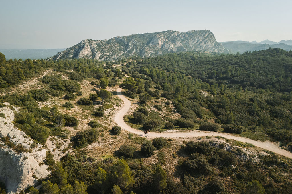
EYGALIERES - Stroll of the Gros Calan
& Laquo; This walk is a total delight in spring. With family or friends, it offers unseen landscape views even for those who know the Alpilles. The mountain pass reveals far away, a picturesque view of the old Eygalières.This trail is a gentle stroll in a joyful atmosphere when, from the end of March, the hilltop pasture becomes covered with flowers, bursting with colour. Anne-Catherine Privat-Madelin, Assignment Manager for Planning Urbanism Landscape Alpilles RNP.
6 points of interest
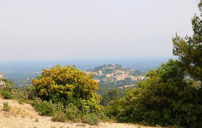
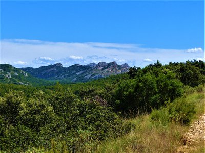
Point de vue sur Eygalières - ©Anne-Catherine Privat-Madelin - PNR Alpilles  Panorama
View of Eygalières
The village of Eygalières as well as the ruins of the castle at its summit, are the last vestiges of the castrum of Aigueria, of which the first writings date back to the 13th century. The village was originally built on a small rocky ridge, allowing its inhabitants to protect themselves against possible attacks, before expanding on the surroundings. The name of Eygalières is closely linked to water, as indicates its Latin name "Aquilaria" or in Provencal "Eigaliero".
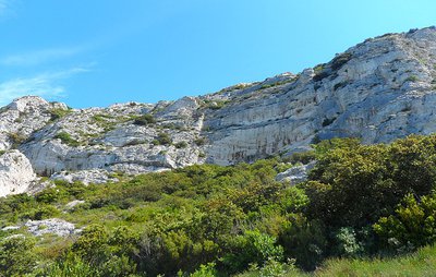
Formation géologique du Gros Calan - ©Jason Gaydier - PNR Alpilles  Geology
Calans
A Calan is a hard limestone escarpment formed between 160 and 90 million years BC. These cliffs are the remains of an ocean presence in distress. Indeed, the Tethys ocean was here during the Jurassic period, the same period that saw the water level decrease. It was then that massifs such as the Alpilles ridges or as the calans were formed. Here, you can distinguish the Gros and Petit Calan because of their size.
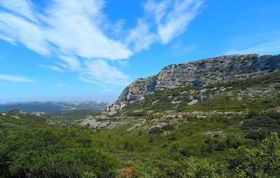
Point de vue du gros Calan et du piémont Nord - ©Jason Gaydier - PNR Alpilles PanoramaAn island in the middle of nowhere
From this viewpoint, you will have the chance to make a brief stop and admire the beauty of the Alpilles. On your right you have the Gros Calan and the Chaîne des Alpilles in the distance. These massifs are the result of tectonic plate movements and the action of the formerly present ocean millions of years ago. Today they are home to flora and fauna that are now the wealth of these places.
Vue sur les Civadières - ©Rémi Sérange - PNR Alpilles  Peak
PeakView of the top of the Opies
If you look up, you will see the Opies massif. This massif, a bit away from the Alpilles, is characterized by a series of ridges where the highest point is located in the territory of the Park: the Opies, at 498m of altitude. From the lookout tower which symbolizes the summit, you can see up to the Alpine peaks! Nevertheless and despite its imposing presence, this massif is fragile and it is advisable to roam other peaks capable of receiving visitors.
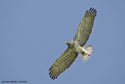
Circaète Jean-le-Blanc en vol - Jean-Pierre MICHEL_LPO PACA  Fauna
FaunaShort-toed snake eagle
Returning from the Sahara for the summer period, the short-toed snake eagle Jean-in-the-blank, Circaetus gallicus, is a raptor with a wingspan of 1.80 m and he can weigh up to 2 kilos. He has the top of the brown wings and the white underside. Its body is dotted with colorful spots, colour and density depending on the individual (between light beige and dark brown). It hovers for a long time in the manner of vultures to hunt its prey, mainly reptiles!
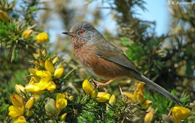
Fauvette pitchou - ©Aurélien Audevard - LPO FaunaThe Dartford warbler
If you see the Kermes oak trees around you, keep an eye out, and the right one! As you could probably see the Dartford Warbler, characterized by its eye circled in red, fond of Kermes oaks. This species has little adaptability, making it dependent on the Mediterranean natural environment and vegetation of low altitude and high density. An insect-eating bird, it also seems to feed on plant material during the harshest season. Do not disturb it!
Description
From the car park, start the hike at the mountain pass cycling milestone AL 120, by following the path marked GR® (red and white).
1 – At the first crossroad with the buried cistern to the right, continue on the left and leave the paths that go to the right and straight. At the next junction, after the curve, turn left on the meandering path.
2 – At the crossroads, veer to the right and take the little path to head to the Gros Calan mountain range.
3 – At the direction sign Stroll of the Gros Calan& Raquo;, turn left and walk along the mountain on the stony path. In the curve, continue on the path, leaving the small track going to the left.
4 – After passing the green cistern in the hairpin bend, take an immediate right on the trail which slopes gently to the concrete cistern and follow it to the junction with the D25.
5 – Cross the main road and take the path on the right in the pine forest. Then follow the road for 350m. (!) Look out for cars in the 90° turn. ! Leave the road after the turn to take the wide path that starts on the right. Continue for 200m to climb, at the junction, the path continuing to the hillock.
6 – After following the switchback path, go onto the small track which plunges down to the right path. It leads to a new path. Ignore the different paths that start from either side to reach the D25, which you will need to cross again. then climb the main trail after crossing the gate.
1 – Back at the first intersection, go to the right on the first part of the hike followed and end the stroll.
- Departure : Car park at the crossroads between the D24 and the D25, Eygalieres.
- Arrival : Car park at the crossroads between the D24 and the D25, Eygalieres.
- Towns crossed : Eygalières and Aureille
Forecast
Altimetric profile
Recommandations
Remain vigilant when passing close to the road.
Information desks

House of the Alpilles Regional Nature Park
2, boulevard Marceau, 13210 Saint-Rémy-de-Provence
Located in the heart of the city centre of Saint-Rémy-de-Provence, the House of the Alpilles Nature Park welcomes you to its completely renovated premises. This new vibrant place is multifunctional: it accommodates the Park's engineering team but also has a public reception space and showrooms. A true resource centre of the Park's heritage, it aims to support and promote locals, visitors and tourists on all 16 municipalities of the Park.
Open Monday to Friday, from 9 am at 12:30 pm and from 1:30 pm to 5 pm.
Free admission.

OTI Alpilles-en-Provence
Place Jean Jaurès, 13210 Saint-Rémy-de-Provence
Access and parking
Coming from Eygalières, the starting point is on the left when arriving at the crossroads between the D24 and the D25.
Parking :
Report a problem or an error
If you have found an error on this page or if you have noticed any problems during your hike, please report them to us here: