Le Mourre Nègre, northern side
"Not climbing the Mourre Nègre would be a big mistake I was told! So I immediately accepted the challenge. The sharp trail on the north side of the steep Grand Luberon, reveals a series of magnificent views to the Alps. On the ridge, the same goes for the south side! A Panoramic view of the Pays d'Aigues, the Durance and the Sainte-Victoire in the distance. At the top again, my eyes sparkle at the Alpilles, the Petit Luberon, Ventoux What a delight! ". says Anne-Camille Vinson - 2nd year of Master's intern at Réseau des Parcs de PACA.
15 points of interest
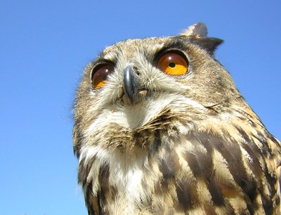
Grand-duc d'Europe - ©PNR Luberon  Fauna
FaunaThe Eurasian eagle owl
The Eurasian eagle owl is one of the largest species of owl (with a wingspan of 1,80m). As great as an eagle, it is still well represented in the territory of the Luberon Park (about sixty couples). It builds its nest in steep cliffs, similar to those that overhang the footpath, where it breeds and rears its young from January to June To cope with the disappearance of the rabbit, it has adjusted its eating behavior to feast on rodents, birds, hedgehogs, reptiles, fishes ...
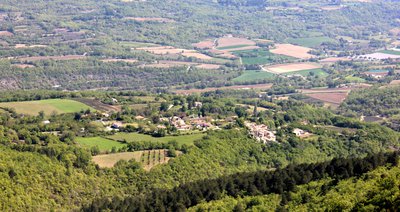
Auribeau et le Mont-Ventoux au loin - ©Anne-Camille Vinson - PNR Luberon  Savoir-faire
Auribeau, a nestled village
Auribeau is a small authentic rural village whose inhabitants are mostly farmers. Nestled in the countryside on the foothills of the Grand Luberon, Auribeau is located at the east end of Claparèdes plateau. The Aiguebrun, a right bank tributary of the Durance, starts in the town. This site was always occupied since there are lots of remains of ancient Bories, and paths dug on the sides of rocks leading to shelter villages during the great invasions.
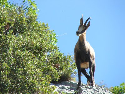
Chamois du Luberon - ©Eric Garnier - PNR Luberon FaunaThe chamois of Luberon
The chamois, Rupicabra rupicabra, has reappeared since the 70s in rare rocky areas of the Grand Luberon. The population is estimated at nearly a hundred in the territory of Regional Nature Park of Le Luberon! Contrary to popular belief, it was not introduced but it recovered a nowadays safe area which once belonged to it a few centuries or even millennia ago. It is not uncommon to see in the winter rutting males chasing one another on the steep cliffs!
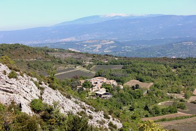
Castellet-en-Luberon et le plateau des Claparèdes - ©Anne-Camille Vinson - PNR Luberon  Panorama
Castellet, a hilltop village
Perched on a hill and overlooked by the ruins of the old Castel (castle in Provence), Castellet is bordered by the Calavon on one side and the Grand Luberon on the other. There are cereals and fruit trees (table cherries), production of table grapes and AOC Luberon wines. The production of aromatic plants (lavendin and sage) makes also the traditional distillery of Castellet work!
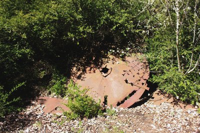
Couvercle d'un ancien four à charbon - ©Anne-Camille Vinson - PNR Luberon Savoir-faireCharcoal kilns
Historically, charcoal burners transformed wood into charcoal directly on the ground of the forest. During the 19th century, metal enclosures of various shapes appeared and replaced the traditional charcoal kilns that required special expertise. In addition to being removable, the kilns allowed faster burning, thus increasing productivity. In Luberon, a few circles of blackened earth remain, and so do rusty metal sheets bearing witness to this activity.
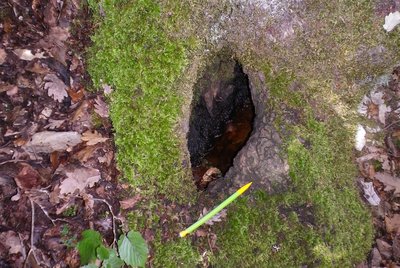
Dendrotelme - ©Pierre Frapa - PNR Luberon  Flora
FloraAncient forest
The surrounding hills are home to a beautiful ancient forest, a true reservoir of biodiversity. Old trees are used as a support or pantry for a great number of species of fauna and flora (lichens, insects,...). The preservation of this forest in a massif affected by programs of wood cutting contributes to sustainable forest management and continuity of mature forests in respect of the Regional Nature Park of Le Luberon.
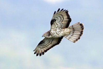
Bondrée apivore - ©DR FaunaHoney Buzzard
The Honey Buzzard is a migratory bird of prey present for its reproduction on our territory in summer. It feeds mainly on hymenoptera (wasps, bumblebees, wild bees,...) which it hunts on open areas close to its place of forest nesting. It can dig up to 40cm to extract its favorite foods: larvae! Beware of stings and that is the reason why the skin surrounding its beak and eyes is protected by small, stiff feathers looking like scales.
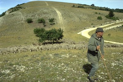
Berger et son troupeau sur le Grand Luberon - ©Hervé Vincent  Elevage et pastoralisme
Sheeps and shepherds, keepers of the peaks!
In May and June, you will encounter sheep grazing. Thanks to them, the exceptional biodiversity of the peaks is maintained. Without grazing, you wouldn't be able to see as many insects, birds and spring flowers. Sheeps prefer, because they choose them, rare plants and limit the closing of the lawns by the forest. Farmers are supported in their work by the Park, the ONF (National Forest Offices) and pastoralists.

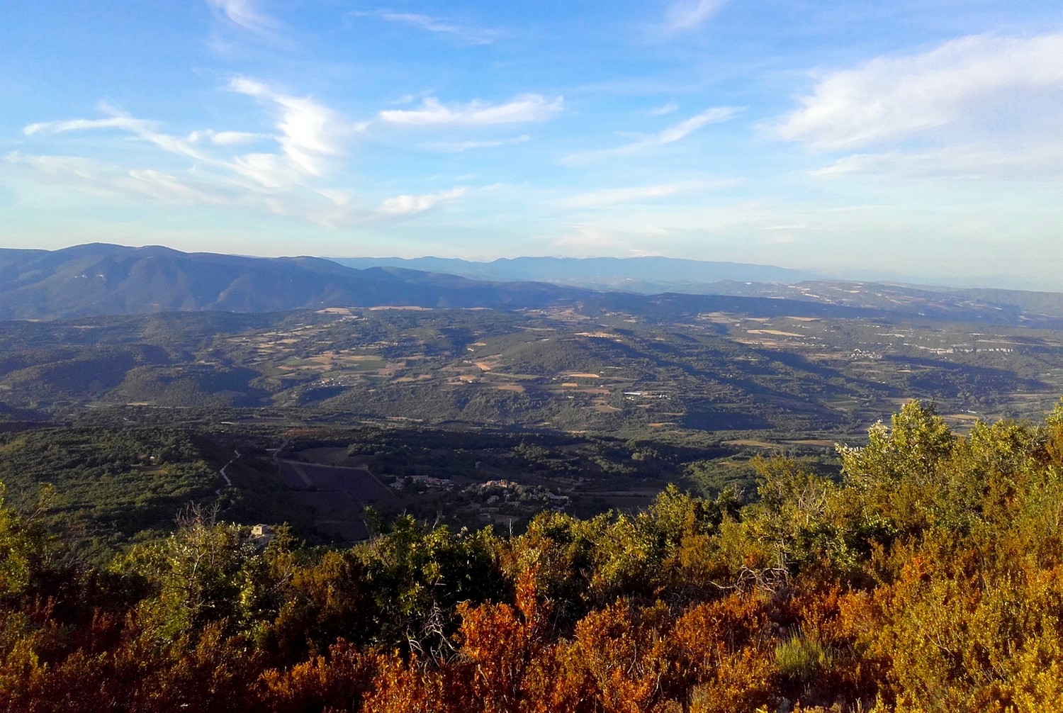
Sommet du Mourre Nègre (1125 m) - ©Eric Garnier - PNR Luberon PanoramaValleys and open spaces
The Luberon is visible from everywhere and very present in the landscape. From the peaks, wide panoramas are also available to us: Our eyes travel across the southern massifs (Alpilles, Sainte-Baume...) and northern massif (Mont Ventoux). But this landscape is also characterized by the very intimate micro atmospheres like the wooded valleys below and the surrounding rocky valleys. At our feet, the mark of man is discreet and increasingly present beyond the Durance.

Vue aérienne du Mourre Nègre - ©Stéphane Legal - PNR Luberon  Geology
I am several million years old!
The Luberon was not built in a day, far from it! Its birth is connected to the birth of the Pyrénées, about 40 million years ago. This is also the case of Provencal Alpilles, Ste-Victoire, Ste-Baume massifs, etc. all oriented east-west. With the formation of the Alps, it has lived for 20 million years, several episodes of deformation leading to its current structure: a wide asymmetrical arch-shaped bend (anticlinal) overlapping the south.

Une balise réfléchissante - ©Anne-Camille Vinson - PNR Luberon FaunaPower lines, air threats
High and medium voltage lines create a real danger for birds’ due to collisions and electrocutions. For large soaring birds (eagles, vultures, storks), these infrastructures represent one of the main causes of human-induced mortality. Solutions exist: The burying of power lines, the installation of beacons improving the visibility of the cables, the renewal of the most dangerous pylons, the creation of perches on them or their better isolation.
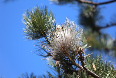
Nid de chenilles processionnaires - ©Anne-Camille Vinson - PNR Luberon FaunaBeware of caterpillar scabs!
The pine processionary caterpillar is the larva of a moth ( Thaumetopoea the pityocampa) only living during the period of reproduction! It is not only dangerous for humans and animals, but also for nature since it can cause serious damage to forests. With their hair and “spiky” look, these caterpillars are easily recognizable because they are always moving one after another.
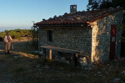
Jas Brémond en fin d'été - ©Eric Garnier - PNR Luberon Elevage et pastoralismeJas, a shelter for the shepherds and flocks
In the Provençal “jas” designates large dry stone (or not) sheepfolds which provide shelter to both animals and people. The word comes from the Latin "jacium": the house, the place where people sleep. In ancient Occitan, it rapidly designated the "park where herds of goats and sheep were sleeping in mountain pastures". Today, the shed houses shepherds during their summer presence in the Luberon ridges for “alpine pasture” in June and July.
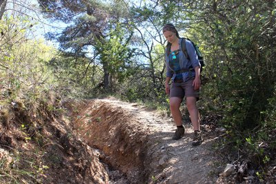
Sentier du Vallon de Roumi - ©Anne-Camille Vinson - PNR Luberon Savoir-faireA trail is made to be worn out!
This saying should be highlighted: the function of a trail is to connect one place to another. However, they are also part of our heritage... and living heritage! The section of the trail that you follow testifies to the torrential rains that increase the erosion of the foundation of the route. Over time, the prohibited traffic of a few motorcycles and the lack of regular maintenance favored the creation of ruts, and a parallel track was created by the simple use of walkers.
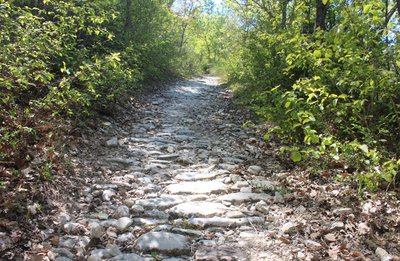
Calade de Saint-Pierre d'Auribeau - ©Anne-Camille Vinson - PNR Luberon Savoir-faireProvencal calades
Calades are cobbledstone paths or sloping paved streets that are found in Provence. The root "cal" refers to the stone and "cala" means "down" in Provencal. By extension, “calader” means pave. The surface consists of stones laid on the edge (on the narrowest part), mainly pebbles from the Rhone or Durance. Some roads and streets were paved to help people and animals walk more comfortable, and also to limit erosion.
Description
Leave the car park and climb right on the paved road (PR). Pass a house and continue climbing on a rocky path. Pass the edge and at the 1st crossing (point 685), turn left (PR). Take the nice balcony path and pass the edges by a succession of uphills and downhills. Continue left in the third valley (PR) and do not go right to the valley of the Trois Eves.
1- At the crossroads "Marauvière", turn right, pass two hairpin bends and continue the ascent. Reaching a vague pass, continue straight and follow the road on the hillside. Exit the forest and lead to the track on the ridges. Turn left and go down 200m.
2- At the "Basse de Cabrière" climb the bump to the right (GR® marking barely visible). Switch, reach the DFCI track and go across to reach the foot of the top bump.
3- At the tank, climb the path that climbs on the north side of the summit and reach the Mourre Nègre. Go around the top (panorama) leaving the antennas on your right hand. Pass under the power line, and head northwest on the path through the summit field. Dive into the undergrowth and reach the DFCI track below.
4- At the track, do not dive in front into the Font Jean de Martin valley (steep and rocky), but turn left and take an immediate parallel path to the right. Rise slightly, pass the small sheepfold of the Jas de Brémond and a few meters below (sign-post), turn right. Start heading down following the edge, then dive to the left into the valley of Roumi (PR). Cut three times the forest track and follow the very craggy trail in certain places (cairns). Falling a fourth time on the track, follow it to the right.
5- At the exit of the first curve, turn right on the trail (PR). Go down, pass three curves and finish with a long cobblestone path section. Turn right to reach the car park.
- Departure : Lucien Peysson car park, Auribeau
- Arrival : Lucien Peysson car park, Auribeau
- Towns crossed : Auribeau, Castellet-en-Luberon, and Cabrières-d'Aigues
Forecast
Altimetric profile
Recommandations
Upstream point 5, be careful with your ankles in the rut!
On the ridges, stay on the paths; sensitive lawns!
Information desks

House of the Luberon Regional Nature Park
60, place Jean Jaurès, 84400 Apt
In the heart the old town centre of Apt, the House of the Luberon Regional Nature Park welcomes you in a town house of the 18th century. The permanent exhibition of the geology museum has a rich collection of fossils evidencing the geological history of the Luberon.
On sale at the shop: books, maps, guidebooks, games, posters...
Open Monday to Friday from 8:30 am to 12:00 pm and from 1:30 pm to 6 pm (and on Saturday, depending on the program). Free admission.

OTI Pays d’Apt Luberon
788 avenue Victor Hugo, 84400 Apt
Du 1er avril au 30 septembre
Ouvert du lundi au samedi de 9h30 à 12h30 et de 14h à 18h.
Juillet et août : Ouvert dimanche et jours fériés de 9h30 à 12h30
Du 1er octobre au 31 mars
Ouvert du lundi au mardi et du jeudi au samedi de 9h30 à 12h30 et de 14h à 18h.
Fermé le mercredi, dimanche et jours fériés.
Access and parking
At 9km southeast of Apt through the D48.
Parking :
Access
- Emergency number :
- 114
More information
Report a problem or an error
If you have found an error on this page or if you have noticed any problems during your hike, please report them to us here: