
SAINT REMY DE PROVENCE - From Saint Rémy to Les Baux
This walk will surprise you by making you climb some reliefs from where you can enjoy outstanding views. From Gard to Var and from Ventoux to the seafront, the landscapes you will see will have no limit. So to your binoculars!
13 points of interest
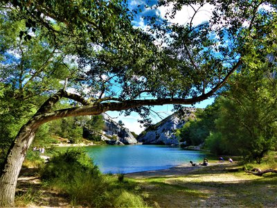
Lac du Peirou - ©Rémi Sérange - PNR Alpilles  Water and rivers
Lake Peiroou
Surrounded by limestone cliffs, Lake Peiroou is an artificial lake, with a capacity of 80 000 m3, retained by a dam. Its name comes from the Provençal "pèiroù" which means cauldron. It was here that the Romans built a dam that supplied water to the city of Glanum, thanks to an aqueduct. It was one of the first "arch dam" of history. The current dam, meanwhile, was built in October 1891, in the same place as that of the Romans, to supply the fountains of Saint-Rémy-de-Provence.

Plantation d'oliviers - ©Rémi Sérange - PNR Alpilles  Produits du terroir
The olive tree
Emblematic culture of the territory of the Alpilles, the olive tree is the symbol of the dry Mediterranean climate. Its multiple trunks are the result of a release at the strain level following a significant frost in 1956. Today, some of the olives and oils produced in the Alpilles are recognized nationally and internationally, benefiting from the Protected Designation of Origin (PDO).

Canal des Alpines - ©Rémi Sérange - PNR Alpilles Water and riversNorthern Alpines Canal
The Alpine Canal network stretches 119 km from Orgon to the Roubines of Anguillon and Vigueirat. Begun in 1826, its construction was slowed by conflicts of interest and ended in 1875. At the time, it was intended to complete the Canal des Alpines meridionales finished in 1772, to supply water to 18 towns and 40 additional mills. ;

Piste DFCI n° AL107 - ©Rémi Sérange - PNR Alpilles  Savoir-faire
The DFCI track
The tracks for the defense of the forests against fire (DFCI) have for purpose,the movement of vehicles of various actors responsible for the prevention of and fight against fires inside the forest massif of the Alpilles. They allow a rapid response, even in hard-to-reach areas and have underground tanks for supply;fast;In water. These trails also offer a network of wide paths suitable for hiking.

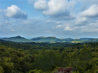
Vue sur les différents massifs - ©Rémi Sérange - PNR Alpilles  Panorama
View of the mountains
In the distance towards north, the Mont Ventoux is outlined on the horizon. It is the highest point of the Vaucluse mountains with its 1911 m altitude. In the foreground, one end of the Alpilles chain stands out and at its feet is Saint-Rémy-de-Provence. Finally, taken between these two reliefs and starting from the right, we can observe the beginnings of the Luberon massif.
Le Mont Paon et le Mont Valence - ©Rémi Sérange - PNR Alpilles PanoramaView of the south-west of the Alpilles
It is with a superb view on the reliefs of the southwestern part of the Alpilles, that one can distinguish Mont Paon and Mont Valence, both 234 meters high. They are bordered by the Vallon de Cabrieres, and farther west, by the Vallon de la Lèque. They were very early places of privilege for the implantation of human, as evidenced by the various vestiges present on Mount Paon.

Les APSIF en action - ©Rémi Sérange - PNR Alpilles Savoir-faireForest Defense Against Fire
Forest Defense Against Fire; provides for the deployment of various actors responsible for the prevention and fight against fires in the Alpilles (fire-fighters, foresters-sappers, agents of the National Forestry Office, Agents of Prevention and Awareness of Forest Fires). These, commissioned by the Regional Natural Park, deliver valuable information on the accessibility of the massif and respect for its biodiversity.
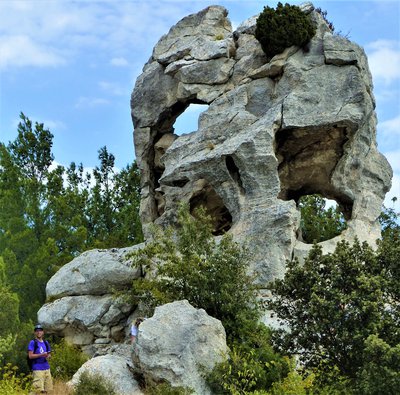
Oeil d'érosion - ©Anastasia Zhukova - OT Baux-de-Provence  Geology
The erosion eye
The erosion eye is a rock, on the heights of Baumayrane, offering a fine example of taffoni;(word of Corsican origin meaning "hole"), common phenomenon around the Baux-de-Provence. Its cavities dug by erosion can have very different shapes and sizes, depending on the structure of the rock and its ability to absorb water. Here, the erosion eye is pierced through, allowing to see through.
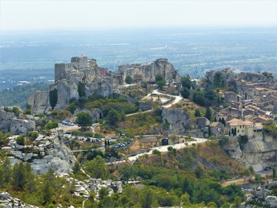
Vue sur le château des Baux - ©Anastasia Zhukova - OT Baux-de-Provence PanoramaView of the Baux-de-Provence castle
Here is a superb panorama at 360 ° C, which offers a breathtaking view of the Baux-de-Provence and their castle. Built in the 11th century under the orders of the lords of Les Baux, this castle was subsequently destroyed several times during the conflicts affecting Provence. The semi-troglodyte specificity of this fortress is that we still found today part of the dungeon relatively well preserved and seen very well from afar, from the surrounding lowlands.
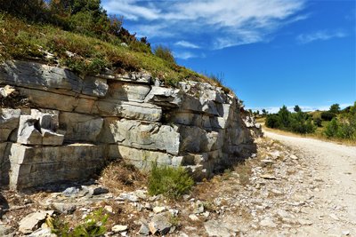
Bancs calcaires apparents - ©Rémi Sérange - PNR Alpilles GeologyLimestone Benches
Following the tectonic pressures of the Eurasian and African plates, and the pleating of the rocks that it created, the Alpilles massif allows to find visible geological strata, called "limestone bench". These strata each correspond to a sedimentary ensemble;which has been formed over many years between two parallel surfaces. ;
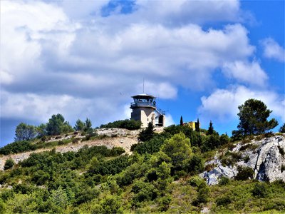
Vigie incendie - ©Rémi Sérange - PNR Alpilles Savoir-faireWatchtower
The Defense of the Forest Against the Fires is articulated around the watchtowers strategically placed at the mountain summits, which allow a 360 ° C view on the Alpilles massif. In summer, they are the meeting point of the various actors operating against fires. From there, they can quickly identify fire departures and deploy the necessary means for interventions.
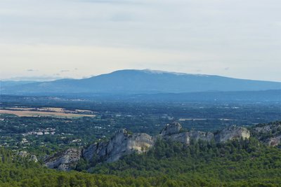
Vue sur le Mont Ventoux - ©Rémi Sérange - PNR Alpilles PanoramaView of Mont Ventoux
Mont Ventoux is the highest peak of the Vaucluse, culminating at 1,911 m. Its altitude makes it visible from afar. In summer, we can notice it at its white summit, suggesting snow. Called also the "Bald mount", the Mont Ventoux owes the whiteness of its summit to the absence of vegetation which leaves its calcareous rocks visible, but also to snow in winter period.

Vue sur la Caume - ©Rémi Sérange - PNR Alpilles PanoramaView on the Caume plateau
Culminating at 378 m of altitude, the Caume plateau is a limestone entity dating from the Upper Cretaceous, which is among the most famous reliefs of the Alpilles. It is also a crossing point of the GR®6 and hosts a rich ornithological biodiversity, with the Bonelli's Eagle, the Egyptian Vulture, but also the jackdaw. To preserve it, a prefectural protection order was put in place.
Description
From the parking, go up track to West through the pines for join the tarred road that comes to Saint-Rémy-de-Provence. Follow it and take the left on the Roman Road and Panouilles. Continue to the Alpines Canal and the Chemin des Servières and Cadenières.
1- At the intersection, turn left (from this point, follow the signs GR® and PR to point 3). Stay on this paved road for 1.7 km, then climb a hill by a path. Join the DFCI track and follow it until the D27.
2- Turn left on this road, go up 250 m, then turn right on the DFCI track AL 107. Pass a barrier and go up the valley called "Gaudre de Valmouriane". After a series of laces, you get to a crossroads.
3- Take the GR®6 on the left towards Les Baux (from this point follow the GR® signs to the car park from the starting point). At the pass, join the D27. Cross it and continue 500 m on an asphalt road, on the left. After the orientation table and a barrier, continue on a track.
4- Pass the watchtower, leave the Lombards track on the right (panel), then DFCI no. AL 112 on the left. Continue for 1.3 km then turn left into a valley and return to the starting point.
- Departure : Lake Peiroou, Saint-Rémy-de-Provence
- Arrival : Saint-Rémy-de-Provence
- Towns crossed : Saint-Rémy-de-Provence and Les Baux-de-Provence
Forecast
Altimetric profile
Recommandations
For your safety, and for the preservation of forest areas, access to natural areas is regulated from June to September. Inquire during the summer period on 08 11 20 13 13 (price of a local call) or on http://bpatp.paca-ate.fr/
A municipal decree during this same period prohibited motor vehicles from accessing the lake. For parking, follow the updated directions on site.
Information desks
House of the Alpilles Regional Nature Park
2, boulevard Marceau, 13210 Saint-Rémy-de-Provence
Located in the heart of the city centre of Saint-Rémy-de-Provence, the House of the Alpilles Nature Park welcomes you to its completely renovated premises. This new vibrant place is multifunctional: it accommodates the Park's engineering team but also has a public reception space and showrooms. A true resource centre of the Park's heritage, it aims to support and promote locals, visitors and tourists on all 16 municipalities of the Park.
Open Monday to Friday, from 9 am at 12:30 pm and from 1:30 pm to 5 pm.
Free admission.

OTI Alpilles-en-Provence
Place Jean Jaurès, 13210 Saint-Rémy-de-Provence
Transport
.Look for public transport times on the site www.lepilote.com in the town of Saint-Rémy-de-Provence
Access and parking
From Saint-Rémy-de-Provence take the D5 direction Maussane-les-Alpilles and before the exit of the village turn right at the indication Lac du Peiroou.
Parking :
Report a problem or an error
If you have found an error on this page or if you have noticed any problems during your hike, please report them to us here: