Alpilles Roquemartine: The Mouriès loop
The beautiful and varied setting of this loop will allow you to roam quiet roads along many vineyards and olive groves. Before strolling through the Alpilles Massif with its impressive rock walls, you will pass through the small town of Aureille, where the tranquility and authenticity are matched only by the beauty of its church.
10 points of interest

Façade de l'église Saint-Jacques-le-Majeur - ©Rémi Sérange - PNR Alpilles  Patrimony and history
The Saint-Jacques-le-Majeur
The church is the place of the Saint-Jacques chapel, they found writings dating from the eleventh century. and has been replaced to accommodate the growing number of parishioners. The building in front of you dates from 1783. He has had several downgrades during the Revolution, but also following the 1909 earthquake that caused the collapse of the bell tower.
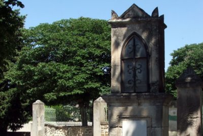
Oratoire Saint-Roch de Mouriès - ©DR Patrimony and historySt. Roch oratory
Topped on a central pillar in stone, this small chapel was built in 1822, against cholera raging in the region. A niche was built, bullet-shaped, covered by a stone flat roof. A marble plaque was added to the building, where one can read "SAINT ROCH PRIEZ FOR US. 1822-1886 ".

Plantations d'oliviers avec couvert végétal - ©Rémi Sérange - PNR Alpilles  Produits du terroir
The route of the olive groves
On D24a connecting Mouriès to Aureille, you will drive for about 5km on a road punctuated by numerous olive groves. You can then explore all the various activities in relation with the planting of olive trees. These activities range from intensive farming with tight plants and bare soil to organic farming with widely spaced plants and vegetation cover.

Débroussaillage mosaïque du LIFE - ©Rémi Sérange - PNR Alpilles  Panorama
Mosaic plant
The irregular plant mosaic is the result of clearing work carried out under the LIFE program of the Alpilles. Its objective is to promote the reintegration of species living in the open air environment. The species include small game, such as the wild rabbit and red-legged partridge, that constitues the main food source for predatory birds of the Alpilles such as Bonelli's eagle and the Egyptian vulture.

Notre-Dame de l'Assomption - ©Rémi Sérange - PNR Alpilles Patrimony and historyNotre Dame de l'Assomption
Once you have reached Aureille, I invite you to make a detour in the center of the village to admire the church of Notre Dame de l’Assomption. The construction of this neo-Romanesque church was initiated by the parish priest, named Father Pauleau, who arrived in 1867 at Aureille. The first stone was laid by the Archbishop of Aix, George Chalandon, on 31 March of that year. His plans are the work of the architect Auguste Veran from Arles.

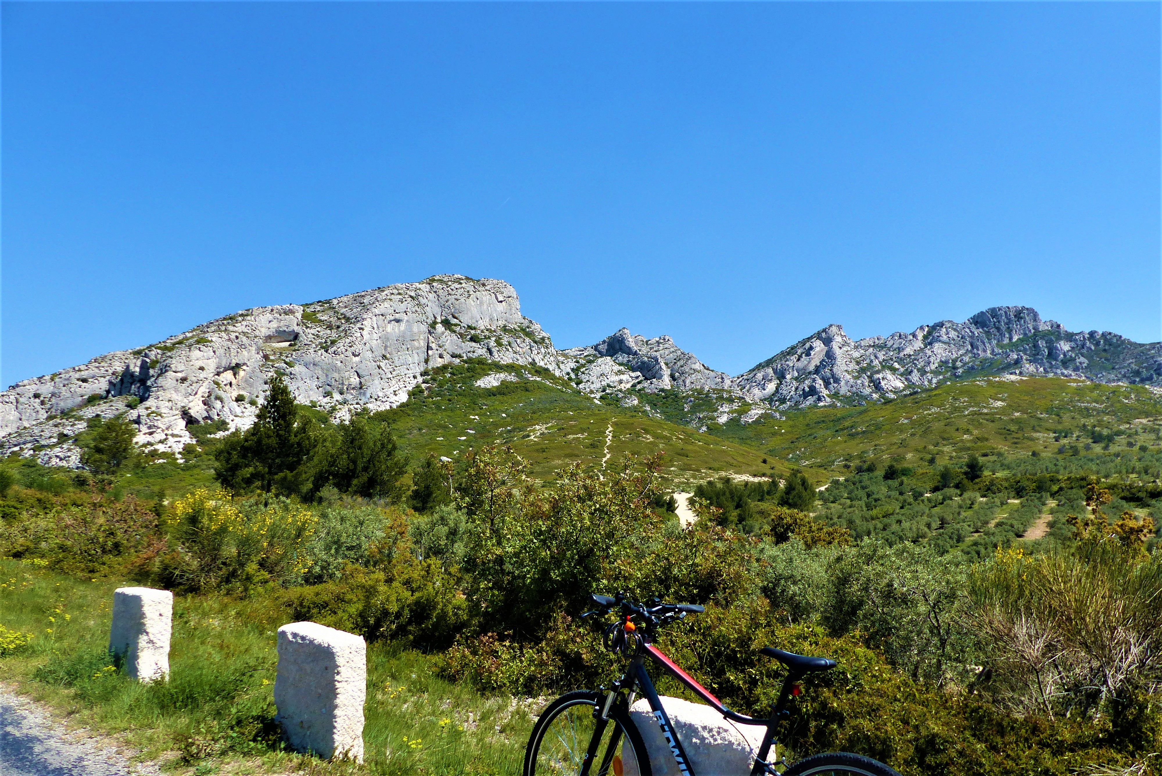
Sommet des Opies et sa tour - ©Rémi Sérange - PNR Alpilles PanoramaView of Les Civadières and Les Opies
Getting out of Aureille, it is possible to contemplate the presence of a set of rocky ridges. They are located southeast of the Alpilles and include Les Civadières and the highest point of the Regional Nature Park: Les Opies 498m high. Some of their rock walls are now the favorite site for many climbing lovers.

Entrée du domaine - ©Jason Gaydier - PNR Alpilles Produits du terroirThe Vallongue farmhouse
Located at the southeast end of the Alpilles ridges, the Vallongue domain has 38 hectares on which is produced wines and olive oils. These vineyards were the first to turn to organic farming, as of 1985! Reds, whites and rosés benefitted from Les Baux de Provence Appelation d'Origine Protégée (AOP) label and Alpilles of Vallongue Indicateur Géographique Protégé (IGP) label, proof a real know-how.
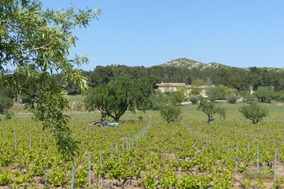
Vignobles du Gourgonnier - ©Rémi Sérange - PNR Alpilles Produits du terroirMas de Gourgonnier
Built in the mid-18th century, the mas was a farmhouse belonging to the abbey of Pierredon. It was in 1950 that the first vines were planted. As he became rapidly aware of benefiting excellent weather conditions, he turned to organic farming in 1975 by joining Nature et Progrès, then by receiving certification from Ecocert. At present, there are 45ha of vineyards and 20ha of olive groves.

La plaine de Maussane-les-Alpilles - ©Rémi Sérange - PNR Alpilles PanoramaView of the plain of Maussane
Before starting the descent and leaving the Alpilles Massif, you will face an open landscape framed by two bas-reliefs, Gypières on your right, and Castellas on your left. At the heart of this picture, you can distinguish the village of Maussane-les-Alpilles, its wet plain and, weather permitting, the surrounding area of Fontvieille.

Canal de la vallée des Baux - ©Rémi Sérange - PNR Alpilles  Water and rivers
The Baux valley canal
This canal, measuring 53km long, was subject to a long process of reflection and design. Designed in 1792, the project will be launched over a century later, in 1914. In a landscape of steppe, it was important to develop human presence and the economy as a hydraulic network irrigates the territory to help the crops survive. This canal supplies all to itself the southern part of the Alpilles.
Description
From the Tourist Office, take the D24 "Avenue Paul Revoil" towards Eygalières until the roundabout.
1 - Cross the roundabout and continue on the D24 until the intersection with the D24a, heading towards Aureille.
2 - Take a right. Continue on the D24a which goes through olive groves over 5km until Aureille and its junction with the D25a.
3 - Take a left towards Eygalières. Go through the village of Aureille and cross the mountain pass named "Pas de la Figuière" to reach the intersection with the D25.
4 - Switch to the left towards Eygalières. Continue to the vineyards of "Vallongue" and the junction with the D24.
5 - Take a left towards Mouriès. After 8km you will reach the place called the "Destet" and the intersection with the D78.
6 - Take a right. Take the D78 until the junction with the D5, before arriving in Maussane-les-Alpilles.
7 - Turn left towards Mouriès. Continue on the D5 until the intersection with the D17.
8 - Do not take the D17. Just before, turn left on the "Chemin d'Alphonse Daudet" and reach the roundabout from the start.
- Departure : Tourist Office, Mouriès
- Arrival : Tourist Office, Mouriès
- Towns crossed : Mouriès, Aureille, Eygalières, Saint-Rémy-de-Provence, and Maussane-les-Alpilles
Forecast
Altimetric profile
Recommandations
For your safety and for the preservation of forests, access to natural areas is regulated from June to September. For more information during the summer, call 08 11 20 13 13 (cost of a local call) or go to www.bouches-du-rhone.pref.gouv.fr or download the free application MYPROVENCE ENVIE DE BALADE (available on Appstore and Android Market)
Information desks
House of the Alpilles Regional Nature Park
2, boulevard Marceau, 13210 Saint-Rémy-de-Provence
Located in the heart of the city centre of Saint-Rémy-de-Provence, the House of the Alpilles Nature Park welcomes you to its completely renovated premises. This new vibrant place is multifunctional: it accommodates the Park's engineering team but also has a public reception space and showrooms. A true resource centre of the Park's heritage, it aims to support and promote locals, visitors and tourists on all 16 municipalities of the Park.
Open Monday to Friday, from 9 am at 12:30 pm and from 1:30 pm to 5 pm.
Free admission.

OTI Alpilles-en-Provence
Place Jean Jaurès, 13210 Saint-Rémy-de-Provence
Transport
Search for the public transport timetables on the website www.lepilote.com in the municipality of Mouriès.
Access and parking
22 km northwest of Salon-de-Provence, through the D17, D17e then D17.
Parking :
Report a problem or an error
If you have found an error on this page or if you have noticed any problems during your hike, please report them to us here: