La Vallongue
Be carefull, bull grazing period, temporarily closed access between february and may. "This walk takes you on the heights of the Alpilles, with breathtaking views. Then come to you the small typical Provencal village that is Aureille, the Crau lowland, or the Opies summit, the highest point of the Alpilles. We never tire of walking in this scrubland, between scents of thyme and rosemary, taking advantage of the panorama. " Sarah Boggio-Pola, Ambassador of the Alpilles RNP.
8 points of interest

Notre-Dame de l'Assomption - ©Rémi Sérange - PNR Alpilles  Patrimony and history
Notre Dame de l'Assomption
Once you have reached Aureille, I invite you to make a detour in the center of the village to admire the church of Notre Dame de l’Assomption. The construction of this neo-Romanesque church was initiated by the parish priest, named Father Pauleau, who arrived in 1867 at Aureille. The first stone was laid by the Archbishop of Aix, George Chalandon, on 31 March of that year. His plans are the work of the architect Auguste Veran from Arles.
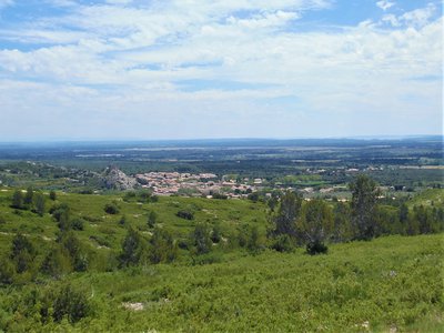
Vue sur le village d'Aureille - ©Sarah Boggio-Pola - PNR Alpilles  Panorama
View on the Aureille village
Dominated by the castle that can be seen at the top of its rocky outcrop, Aureille is at the foot of the Alpilles massif and opens onto the Crau lowland. The center of the village was formerly surrounded by a wall to protect itself, hence the shape of houses adjacent to each other. Today, Aureille remains a typical Provencal village.
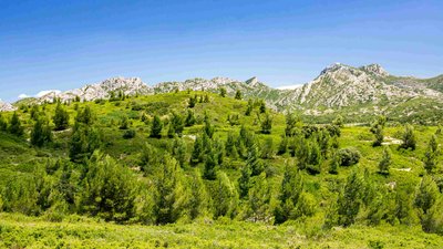
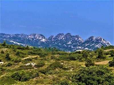
Les Civadières et les Opies - ©PNR Alpilles PanoramaView of the Civadières and Opies
This viewpoint is characterized by two of the oldest geological formations in the Alpilles, dating from the Jurassic period. ; On the left, the crest of Civadières, 446 m high, and on the right, the highest point of the ^park territory: the Opies, 498 m high From the tower that symbolizes the summit, it is possible to see up to the alpine massifs. This tower was a watchtower, built at the dawn of the twentieth century, to monitor the massif against fire. ;
Débroussaillage mosaïque du LIFE - ©Sarah Boggio-Pola - PNR Alpilles  Flora
FloraPlant mosaic
This irregular plant mosaic is the purpose of clearing work carried out within the framework of the LIFE program of the Alpilles. It consists in promoting the reintegration of species living in an open environment. It is small game, such as the wild rabbit and the red partridge, the main sources of food for predatory birds of the Alpilles such as the Bonelli's Eagle and the Egyptian Vulture.
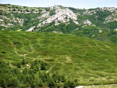
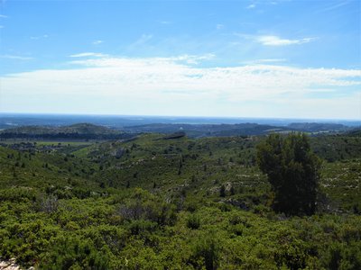
Les crêtes des Alpilles - ©PNR Alpilles - Rémi Sérange PanoramaView of the Caume plateau and the Alpilles ridge
Culminating at 378m above sea level, the plateau of La Caume is a limestone entity traversed by the GR®6. This place hosts a rich ornithological biodiversity, with the Bonelli's Eagle, the Egyptian Vulture, but also the jackdaw. It is prolonged on its right by the Alpilles ridge, chain of small reliefs culminating between 300 and 390 m, and which joins the Calans d'Eygalières. ;
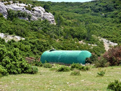
Citerne accompagnée d'un abreuvoir - ©Sarah Boggio-Pola - PNR Alpilles  Elevage et pastoralisme
The flocks against the fire
The Alpilles landscape has been shaped by centuries of pastoralism. In the massif, sheep and goat herds play an important role in the maintenance of the natural area: by eating the grass and a part of the shoots of trees and shrubs, they slow down the scrub. This practice contributes to the protection of the forest against fire. The tank shows these practices combining pastoralism and fire fighting.
De la garrigue à perte de vue - ©Sarah Boggio-Pola - PNR Alpilles FloraGarrigue
The scrubland (Provençal "garrigo") is a plant formation characteristic of the Mediterranean regions. This formation, which is established in limestone massifs in dry ground, results generally from the degradation of the oaks forests. In France, it occupies about 400 000 ha, mainly in Provence and Languedoc. The scrubland can be a place of pastoral activity and a source of small wood for crafts.
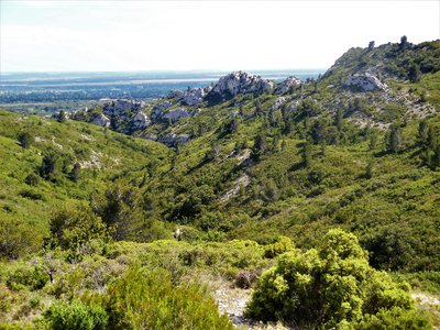
Vue sur le Pas du Cerf - ©Sarah Boggio-Pola - PNR Alpilles PanoramaView of the Pas du Cerf
The small relief of the Pas du Cerf, 242 m high, invites to follow a path that runs along its apparent limestone walls, while;sinking into a small valley conducive to the formation of scrubland. It offers a crossing point between the southern foothills of the Alpilles massif and the Crau lowland that extends to the sea.
Description
From the parking, return on the D25a. Take it on the right towards Eygalières and turn left on the Estandedou road. At the crow's feet, stay on the right, Chemin Saint-Jean, and continue for 400 m.
1- Go right up the path of the water tower. Exceed the tank and continue to a tank. Then take the path on the right for 900 m
2- Facing a fork, climb the left path. At the next intersection, take the right one. Continue on this road for 2 km, leaving on your right the lookout tower.
3- At the intersection with the GR®6, turn left, then 30 m further, turn to the right. Follow this road for 500 m, then fork on the trail to the left.
4- For the next two intersections, take the trail on the left. Carry on on this trail for 2 km. At the end of the path, facing a field of olive trees, take the path on the left.
5- At the junction, follow the path on the left, guided by the sign "Aureille 1,5 km". Continue on the same path up to the village and the starting point of the hike.
- Departure : Stadium parking, Aureille
- Arrival : Aureille
- Towns crossed : Aureille and Mouriès
Forecast
Altimetric profile
Recommandations
For your safety, and for the preservation of forest areas, access to natural areas is regulated from June to September. Inquire during the summer period on 08 11 20 13 13 (price of a local call) or on http://bpatp.paca-ate.fr/
Information desks
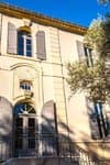
House of the Alpilles Regional Nature Park
2, boulevard Marceau, 13210 Saint-Rémy-de-Provence
Located in the heart of the city centre of Saint-Rémy-de-Provence, the House of the Alpilles Nature Park welcomes you to its completely renovated premises. This new vibrant place is multifunctional: it accommodates the Park's engineering team but also has a public reception space and showrooms. A true resource centre of the Park's heritage, it aims to support and promote locals, visitors and tourists on all 16 municipalities of the Park.
Open Monday to Friday, from 9 am at 12:30 pm and from 1:30 pm to 5 pm.
Free admission.

OTI Alpilles-en-Provence
Place Jean Jaurès, 13210 Saint-Rémy-de-Provence
Transport
Access and parking
Parking :
Report a problem or an error
If you have found an error on this page or if you have noticed any problems during your hike, please report them to us here: