The Quarter from Saint-Pierre
A hike that allows you to access an exceptional site in a protected natural area for its biological, geological and landscape riches with the beautiful beaches of Lake Esparron to reach the cliffs with remarkable views and you will then walk on the old canal guard trail and its many works overlooking the lake and coves to get to the bucolic "Saint Julien Plage" or it is good to stroll on the banks of the lake.
10 points of interest
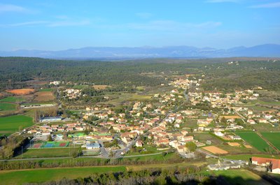
La plaine de Saint Julien et le hameau de Saint-Pierre - Stefano Blanc - PNR Verdon  Patrimony and history
Panorama on Saint Pierre
Saint-Pierre is the hamlet among the 28 that is the more important in the municipality, he became, in 1929, the administrative center of the commune, previously located in the old village; At the time, the relocation was at the origin of great controversy, but was it fully justified because in 1926 the number of inhabitants in the lowland was 593 against 77 to the perched village!
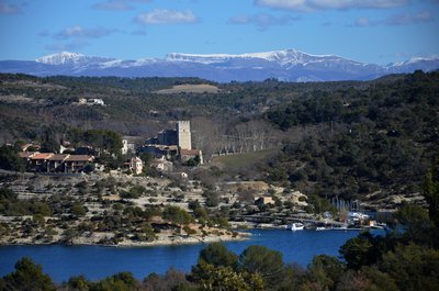
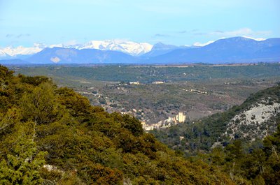
Au loin les Préalpes du Verdon - Stefano Blanc - PNR Verdon  Panorama
Far off the Chiran
From the limestone cliffs overlooking the lake we have a magnificent view of Esparron de Verdon and its castle, we can also see in the distance the snow-capped Mount Chiran which is the second summit of the Verdon Prealps (1 905 m) after its neighbor on the right the Mourre de Chanier (1,930 m). Just above the keep the Grand Mourre (1898 m). The Chiran is separated from the Mourre de Chanier by the Portal of Blieux, col of 1,595 m of altitude.
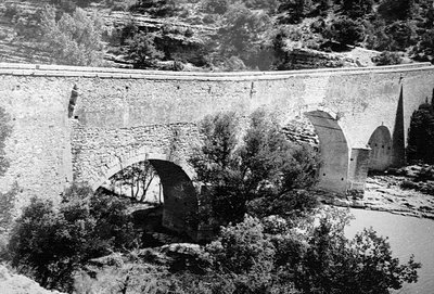
Le pont coupé - DR Patrimony and historyThe cut off bridge
Here the little road seems to flow into the lake. It has not always been so. In 1967, the launching of the lake submerged a stone bridge by 12 meters with three arches that spanning the Verdon connected "Le Quartier" to the rest of the Esparron town. Passage between the Var and the Alpes de Haute-Provence This bridge built in 1725 by the municipality of Arles was a passageway for transhumance herds between the Crau and the pastures of the Pre-Alps avoiding the quirks of the Verdon.
Avec les Alpes ça se vente - Stefano Blanc - PNR Verdon PanoramaBetween Provence and the Alps
Just before going down towards the lake an opening is offered to you with the view on the village of Esparron de Verdon, the immense plateau of Valensole and on the bottom the Alps massifs, you are at the heart of the high Provence, the prevailing winds with evocative names Tremontano - Tems dré - Montagnero - Ventouresco often bring back the freshness of the snow-capped peaks.
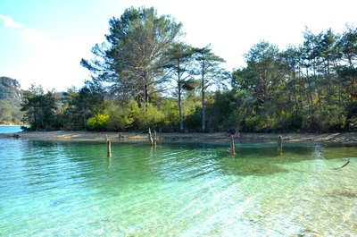
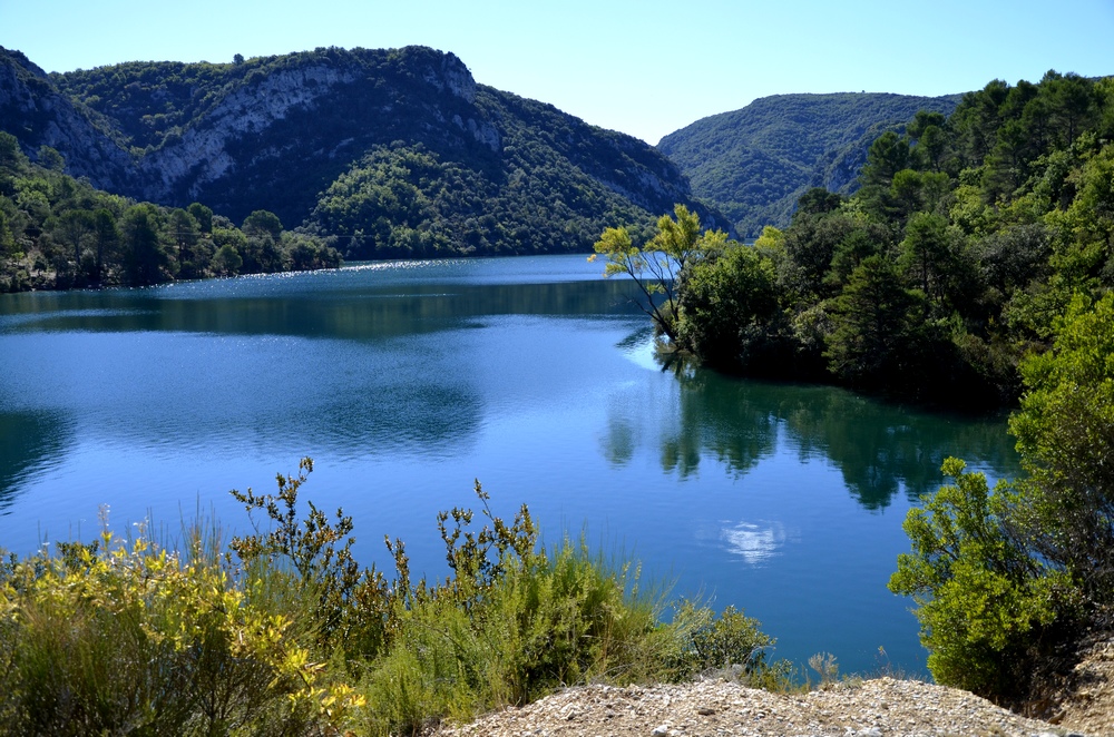
Comme un air de Caraïbes - Stefano Blanc - PNR Verdon  Water and rivers
Like a Caribbean air
The impoundment of Lake Esparron in 1969 drowned the rich agricultural lands of the valley but in return the rise of the waters allowed to redraw the banks leaving sometimes beaches, sometimes steep cliffs, redrawing the landscapes that were transformed into an idyllic place if only by the colour of the water or by creating real small coves.
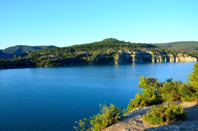
L'ENS la Barade vue depuis la rive droite - Stefano Blanc - PNR Verdon Patrimony and historySensitive Natural Area
The Sensitive Natural Areas of the Var, known as ENS, are sites located in environments remarkable for their biological diversity. They are inherently fragile, rare or endangered. These treasures of biodiversity are managed according to this fragility. Appropriate amenities enhance their wealth and avoid over-frequenting harmful environments. The County Council strives to preserve the remarkable sites and the landscapes, to safeguard the natural habitats.
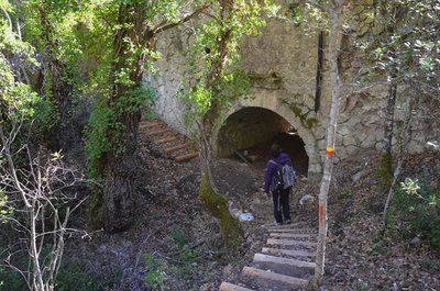
L'aqueduc de la Barade - Stefano Blanc - PNR Verdon Patrimony and historyBridge or aqueduct?
Seen from below it looks like a bridge but it is the water of the old canal of Provence that was ended in 1875 which passed over then it is indeed an aqueduct, one of the many remarkable works of this old canal which operated until 1969 and it is the water intake of the canal of Provence with the creation of the lake which took the relay to convey the water until Aix en Provence, Marseilles, and many cities from the south of Provence.
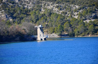
Prise d'eau d'EDF et du canal de Provence - Stefano Blanc - PNR Verdon Patrimony and historyThe intake from the canal de Provence
The first of two large water intakes contributing to the power supply of the EDF Vinon sur Verdon and the Canal de Provence to supply domestic and agricultural water, 116 municipalities, including Marseille, Toulon and Aix-en-Provence. The water then passes through the Maurras Gallery and other galleries and open channels to start as Canal de Provence near Rians.
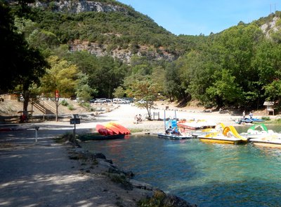
Les plages de Saint-Julien - Stefano Blanc - PNR Verdon Water and riversSaint Julien-Plage
Saint-Julien plage was born at the creation of the lake and over time became a small paradise very popular with locals, a haven of peace where it is good to come to refresh after long sunny days in the shade of the oaks along the banks of the lake.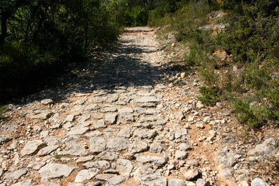
La voie pavée - Stefano Blanc - PNR Verdon Patrimony and historyMedieval route or Roman road
If you are careful the path is a true archaeological treasure, indeed there is a paved path, medieval for some, Roman for others, it is true that here the Verdon valley has served as a place of passage from time immemorial for but also for transhumance herds between Crau and the Prealps pastures. In 1725 the town of Arles built a bridge a little further upstream avoiding the vagaries of the Verdon in 1967 the launch of the lake has submerged it.
Description
Exit the car park, go up the steps past the post office and continue to the roundabout and turn right on the Terdobbiate street follow the signs GR® de Pays (yellow and red) to the l'éclou hamlet..
1- Turn left, cross the hamlet. Walk in the undergrowth and go down again to join a tarred path.
2- Turn right and 150 m further continue along the large dirt track on the left.
3- At the crossing of the tracks, leave the big track that goes straight (barrier) and continue on the right. At the Pole 64 "Gabiane” continue straight following the yellow and red markings
4- Follow the track that continues on the right.
5- At the fire hydrant go down to the left for 1.6 km.
6- Continue to descend to the right.
7- Get to the SCP house turn right at the post "Le Quartier" pass next to the barrier and continue towards the lake. At the post 20 turn left and follow the old canal by the small path.
8- At the (pole 21 ) turn right and continue to walk on the edge of the creeks, pass the lake pontoon (post 22) and follow the beaches bypassing the lawns always following the yellow and red markings.
9- Cross the old canal and go up by the large track opposite to (post 23, balcony of the lake).
10- Turn right and follow the signs (yellow and red) on the cliffs and do not leave the marked trails. At the end go down to reach the edge of the old canal.
11- At the pole 24, cross the passage in the old canal and continue on the flat path between the lake and the canal and head for Saint Julien beach.
12-At Saint Julien beach turn around and come back by the same road to point (11) "the Balcony of the lake" at this level turn right and go up the old medieval road. Pass the barrier of the E.N.S and get to a platform down the left track and join the point (7 le Quartier). Take the same path for the return to Saint-Pierre.
- Departure : From Saint-Pierre
- Arrival : Saint-Pierre
- Towns crossed : Saint-Julien and Esparron-de-Verdon
Forecast
Altimetric profile
Recommandations
Provide 3L of water per person, a hat and walking shoes. From June 15th to September 15th check the opening of the massifs by looking at the prefecture website in "find out more" at the bottom of the page (Fire risk - access to the forest massifs). Beware of the locality you enter a ENS, Sensible Natural Space which is a protected area of ??the Var department, so it is forbidden to pick, cairns, to get out of the marked trails and keep dogs on a leash and of course bring back your waste. Caution when walking along the canal, watch the children. ?
Information desks
House of the Verdon Regional Nature Park
Domaine de Valx, 04360 Moustiers-Sainte-Marie
House of the Verdon Regional Nature Park

OT de Brignoles - Provence Verte & Verdon Tourisme
Boulevard Grisolle, 83670 Barjols
Access and parking
Parking :
More information
Report a problem or an error
If you have found an error on this page or if you have noticed any problems during your hike, please report them to us here: