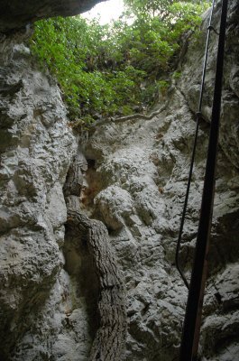
Traverse de l'échelle
The rough descent complemented with handrails to move from one ledge to another, leads to 150m below the deepest gorges. Then, following a riverside, the route rises abruptly on the opposite bank and escapes in the end by the pitch through the scale best climb with caution. An active discovery that requires crossing several air and technical passages on cliff edges, sometimes exposed despite the equipment. A real treat.!
18 points of interest
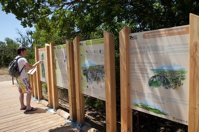
Zone d'accueil de l'ENS - ©Hervé Vincent  Patrimony and history
The ESA (environmentally sensitive area) of the gorges of Oppedette
The department of Alpes de Haute-Provence, with the help of the Region, of the Commune and the Park, got together to accomplish the rational, harmonious and sustainable development of this remarkable but fragile site. The latest landscaping and protection projects were completed in 2009. The entire project of the sensitive natural areas or ESA (study, acquisitions, works) cost €287 641. ! It is now up to all the visitors to contribute to its preservation, adopting a responsible behaviour.
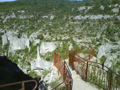
Belvédère est d'Oppedette - ©Eric Garnier - PNR Luberon  Panorama
Two prefects, two viewpoints!
"It is here, in the presence of two prefects, that was cut in 1951, the symbolic ribbon of the first gorge trail. Hence the name of ''Belvédère des deux préfets''! From there on, the language uses have simplified the name to ''Belvédère du sous-préfet", then ''Belvédère des gorges''...". Mr. Fayet, a former teacher of Oppedette.
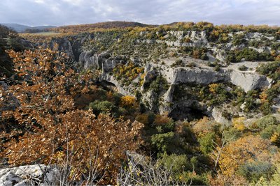
Paysage des gorges en automne - ©Vincent Damorette - Coeurs de nature-Sipa PanoramaA canyon in its wooded setting
Barely visible in the landscape, you will need to go to the site to discover the country of Oppedette, a rugged landscape and covered with woodlands. What reward once on the spot: a "magnificent" landscape reveals the deep gorges forming a canyon that you can embrace or roam. In this wooded setting, viewpoints are occasionally open at the hilltop village of Oppedette and the Lure mountain. These areas seem to have evolved over time without any pressure related to human activity.
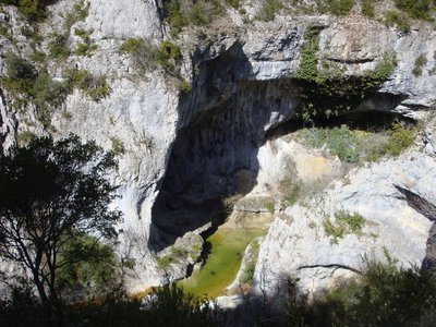
Arche sous le belvédère - ©Eric Garnier - PNR Luberon  Geology
The power of water
The two arches, visible immediately under the viewpoints, coincide, like many others with an interaction of underground rivers (paleo) at the beginning of the excavation of the canyon. Across, the cliff has many niches, due to the rainwater flow and frost weathering, which shatters rocks.
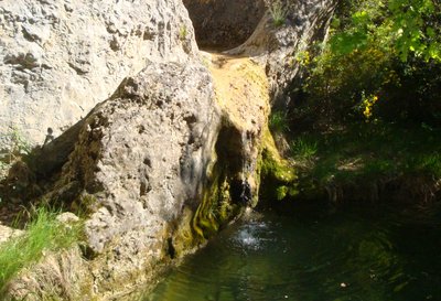
Baume de Font-de-Peyrou - ©Eric Garnier - PNR Luberon GeologyThe Baume de Font-de-Peyrou
Below, across, near the bottom of the Calavon, there's a cave. We call it "baume-porche" because it is at the mouth of a tunnel. A spring accumulates tuff there. Afterwards, the river enlarged this spring into a meandering balm.
Tuf au fond des gorges - ©Eric Garnier - PNR Luberon  Flora
FloraWhat is tuff?
On the opposite bank upstream, you can observe a great balm where water seeps and benefits many mosses and ferns. You may not be able to see it from the road, but this flowing limestone water redeposits on the ground some of its elements by trapping plant and animal debris. Tuff or travertine is this fragile limestone, light and airy, always rare and located in Provence. It is essential never to trample or pick it at risk of causing irreversible damages!
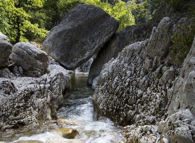
Bloc suspendu au fond des gorges d'Oppedette - ©David Tatin GeologyCalavon, the stone river
According to toponymists, these short gorges, narrow and spectacular (of 2.5km long 140m wide and 100m deep) would be the reason for naming the Calavon river which flows from Banon, on the foothills of Mount Lure toreach the Durance in Cavaillon. "Cal" means stone and the Celtic word "Avon" means river.
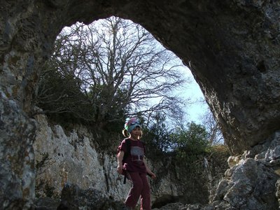
C'est du lierre ! - ©Laurent Michel - PNR Luberon FloraRemarkable ivy
Without falling off the ladder, do not forget to admire this impressive Ivy plant, which starts at the bottom of the pothole and climbs along the rocky wall. Covered in leaves when it is exposed to light, the bare trunk is about 8m long, but the immeasurable ramifications grow well above the wall. This venerable tree is registered in the inventory of remarkable trees of the Luberon RNP.
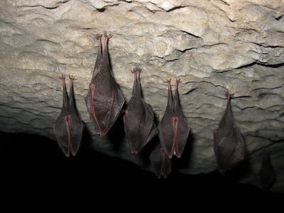
Colonnie de petits rhinolophes - ©DR  Fauna
FaunaSmall but precious flying mammal
Worthy representative of the many bat species, the Lesser Horseshoe Bat (size 4cm, 22cm wingspan, weight 6g) has established on the plateau of Vachères, one of the last bastions of Provence. In winter it occupies favourable underground cavities, such as the sinkhole of the ladder. It starts to hunt between 15 and 30 minutes after sunset. It identifies insects at short distances and captures them most often in flight.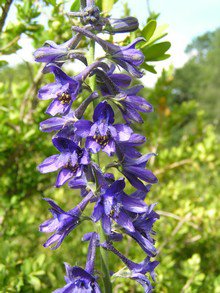
Dauphinelle fendue - ©Laurent Michel - PNR Luberon FloraBeauties of the rocks
Viewpoints and ledges attract us for the views they offer... They are also the preferred habitat of a very specific flora which can adjust to extreme drought and lighting conditions. The Larkspur (Delphinium fissum) and lilacs with laciniated leaves (Hesperis laciniata) are two beautiful representative flowers, rare in the local area. The Larkspur is even protected in our region. It is therefore appropriate to keep them out of our quest for view points!
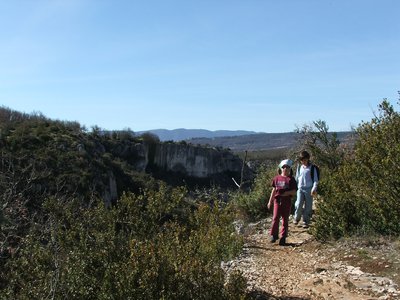
Rive droite des Gorges d'Oppedette - ©Eric Garnier - PNR Luberon PanoramaOn the way, I embrace the Luberon attitude!
The Oppedette site is a remarkably rich and diverse area which, despite the efforts of protection and management, remains very fragile. Let us protect it, together, by following some basic rules of a responsible hiker. The sum of isolated damages is never trivial! On this balcony path, while keeping a grip on the trail, avoid the repeated trampling of plants and insects, such as the formation of gully erosion lanes in the scree.
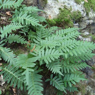
Polypode vue du dessus - ©DR FloraA xxxx of liquorice
At either side of the banks, the bracken fern has spread its roots. It is described and called "réglisse des bois" as some have chewed its roots which gives a taste of liquorice.
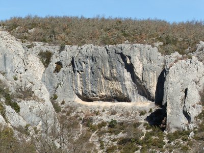
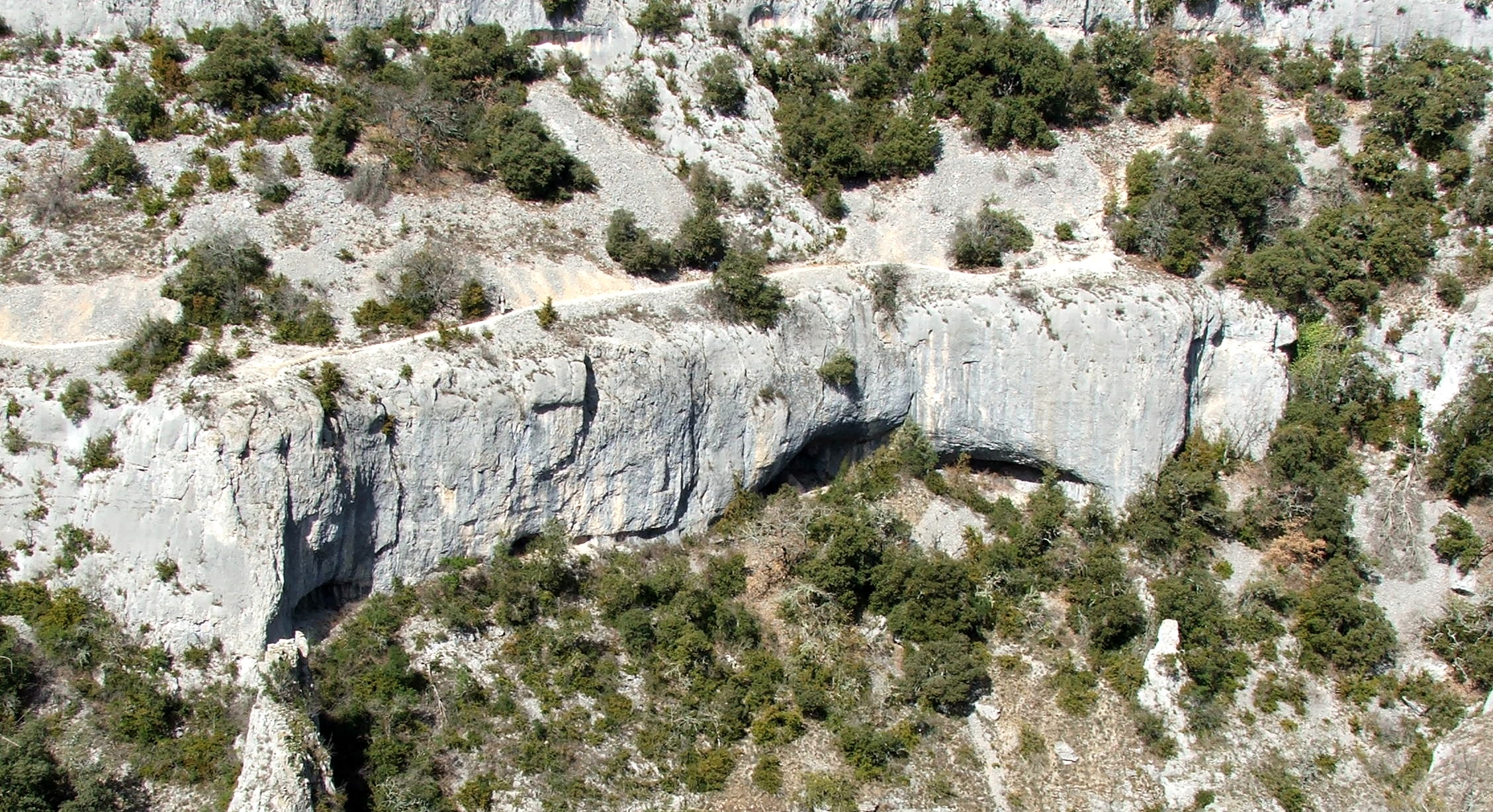
L'unique falaise des gorges ouverte à l'escalade - ©Eric Garnier - PNR Luberon PanoramaThe pleasure of climbing...
If you practice rock climbing, feel free to enjoy a few tracks equipped by the FFME on the cliff overlooking the trail. Because of issues related to the protection of birds, it is the only authorized and equipped area for rock climbing in the gorges of Oppedette. To the right, enjoy the easier lanes and, in the middle, the more difficult ones. After the effort, a splendid view of the entire circus uphill! Please note that free climbing is a sport governed by specific rules of practice; respect them.!
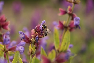
Abeille butinant une fleur de sauge - ©PNR Luberon FaunaA world without bees?
35% of what we eat depends directly on the work of bees. But nowadays, bees are experiencing alarming winter mortality: 20 to 30% of the hives do not survive the winter. Blame the pesticides used in intensive farming that are extremely dangerous to bees. Without bees, it is estimated that 80% of plants would disappear from the lack of pollination.
Lierre grimpant sur les falaises du village - ©Eric Garnier - PNR Luberon FloraIvy flowers, friend of the bees!
At the edge of the trail, large ivy flowers parade on the cliff. Their flowering lasts from September to October and fruiting occurs in late winter, early spring. The Ivy flower therefore presents a reversed phenological cycle compared to plants. Its flowers are among the last to provide pollen for bees. A bee is directly related to the ivy; Ivy bees (Colletes hederae). You can see it flying until early November if the weather is mild and lenient.
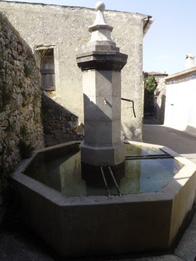
La fontaine du village à plan octogonal - Jérémie Haye - PNR Luberon Patrimony and historyThe wash fountain of the town
Located at the entrance of the village, the building holds a fountain, a wash-house and a drinking trough. Supplied by a spring from the hamlet of Fenouillet, the fountain was built in the mid 19th century. Octagonal in shape, it has a central shaft which is nearly 3.70m high. The wash-house, meanwhile, has two basins: the largest was used for washing; the smallest, near the fountain, used for rinsing.
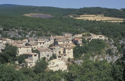
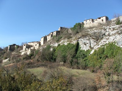
Oppedette, village perché - ©Eric Garnier - PNR Luberon Patrimony and historyOppedette : Hilltop villages
Overlooking the entrance of the gorges, perched on its rocky spur, the village of Oppedette (whose name comes from the Celtic-Ligurian oppidum on which it was built) was frequented from the Palaeolithic (remains dated of about 40 000 years) . Oppedette is a typical Provencal village with narrow streets and facades where the coating has faded over the time and have exposed the limewashed masonry stones.
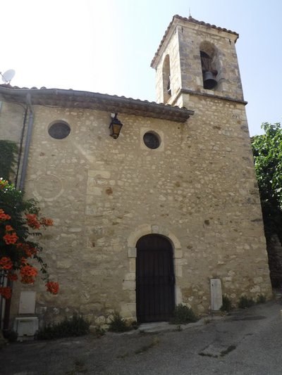
La façade de l'église Saint-Didier - Jérémie Haye - PNR Luberon Patrimony and historyThe church Saint-Didier
The church was built in 1834 on the spot of an ancient chapel as evidenced by the collages and the reuse of masonry on the façade. This later-built building in an already existing structure is why this church is not strictly facing east. In 2000, the town of Oppedette, supported by the technical services of the Park, restored the building to preserve this remarkable element of the rural heritage.
Description
From the car park, go right of the two viewpoints (accessible to persons with disabilities), then take the small winding path that switches left in the gorges. A little further down, cross on the right a first jump using the handrail, and then continue the narrow path with caution. Pass along the last passage equipped with handrails land reach to the edge of a basin on the shores of Calavon.
1 - Turn left and continue advancing in the best possible way along the left bank. Cross a short rocky passage, then continue through the gorges until a more narrow passage.
2 - Cross the river ford (caution in case of flooding!) and locate across the entrance of the trail that goes back on the right bank opposite (pole). Continue slowly on steep slope, then at the top of the valley, go into the dark and damp pitch. Climb the ladder and go onto the sunny side.
3 - Turn left, walk past a viewpoint, and then continue on the cliff path. Go up a little, then cross a rocky path. Then go down between the cliff edge and a rock slide, to reach the upstream circus of the gorges. At the end of the beautiful cliff, hurtle down the switchbacks up to the river.
4 - Cross the ford of the Calavon (caution in case of flooding!), head across, then follow a stony path, reach the village at the top of the rocky outcrop. In front of the town hall, turn right, enter the heartof the village and take an alley on the left to reach the plateau. Leave the obvious wide path, take a right at the cemetery and follow the trail through the grass to emerge again at the base of the gorges. Turn left at the view point and reach the car park from the starting point.
- Departure : Parking area of the Belvédères, in Oppedette
- Arrival : Parking area of the Belvédères, in Oppedette
- Towns crossed : Oppedette
Forecast
Altimetric profile
Recommandations
This itinerary is reserved for hikers who do not fear the void! To be avoided by all means during rainy or foggy weather.
- A series of air and technical passages on cliff edges, sometimes exposed despite the existing equipment (handrails).
- 2 fording sites; turn around in case of flooding!
- Steep slope and ladder climbing (with railings).
- Many inconvenient rocky passages (limestone pavement).
Remember to bring enough water, especially in the hot sun!
Information desks

Luberon UNESCO Global Geopark
60, place Jean Jaurès, 84400 Apt

House of the Luberon Regional Nature Park
60, place Jean Jaurès, 84400 Apt
In the heart the old town centre of Apt, the House of the Luberon Regional Nature Park welcomes you in a town house of the 18th century. The permanent exhibition of the geology museum has a rich collection of fossils evidencing the geological history of the Luberon.
On sale at the shop: books, maps, guidebooks, games, posters...
Open Monday to Friday from 8:30 am to 12:00 pm and from 1:30 pm to 6 pm (and on Saturday, depending on the program). Free admission.

OTI Pays d’Apt Luberon
788 avenue Victor Hugo, 84400 Apt
Du 1er avril au 30 septembre
Ouvert du lundi au samedi de 9h30 à 12h30 et de 14h à 18h.
Juillet et août : Ouvert dimanche et jours fériés de 9h30 à 12h30
Du 1er octobre au 31 mars
Ouvert du lundi au mardi et du jeudi au samedi de 9h30 à 12h30 et de 14h à 18h.
Fermé le mercredi, dimanche et jours fériés.
Transport
Access and parking
From Apt, take the D900 for 15km then take the D33 and D155 towards Oppedette. From Forcalquier, take the D4100 for 25km then 3km after Céreste, take the D33 and D155 towards Oppedette.
Parking :
Access
A parking area, a viewpoint and information panels are available to persons with disabilities in the parking area of the viewpoints located at the southern entrance of the village.
- Emergency number :
- 114
Source

Report a problem or an error
If you have found an error on this page or if you have noticed any problems during your hike, please report them to us here: