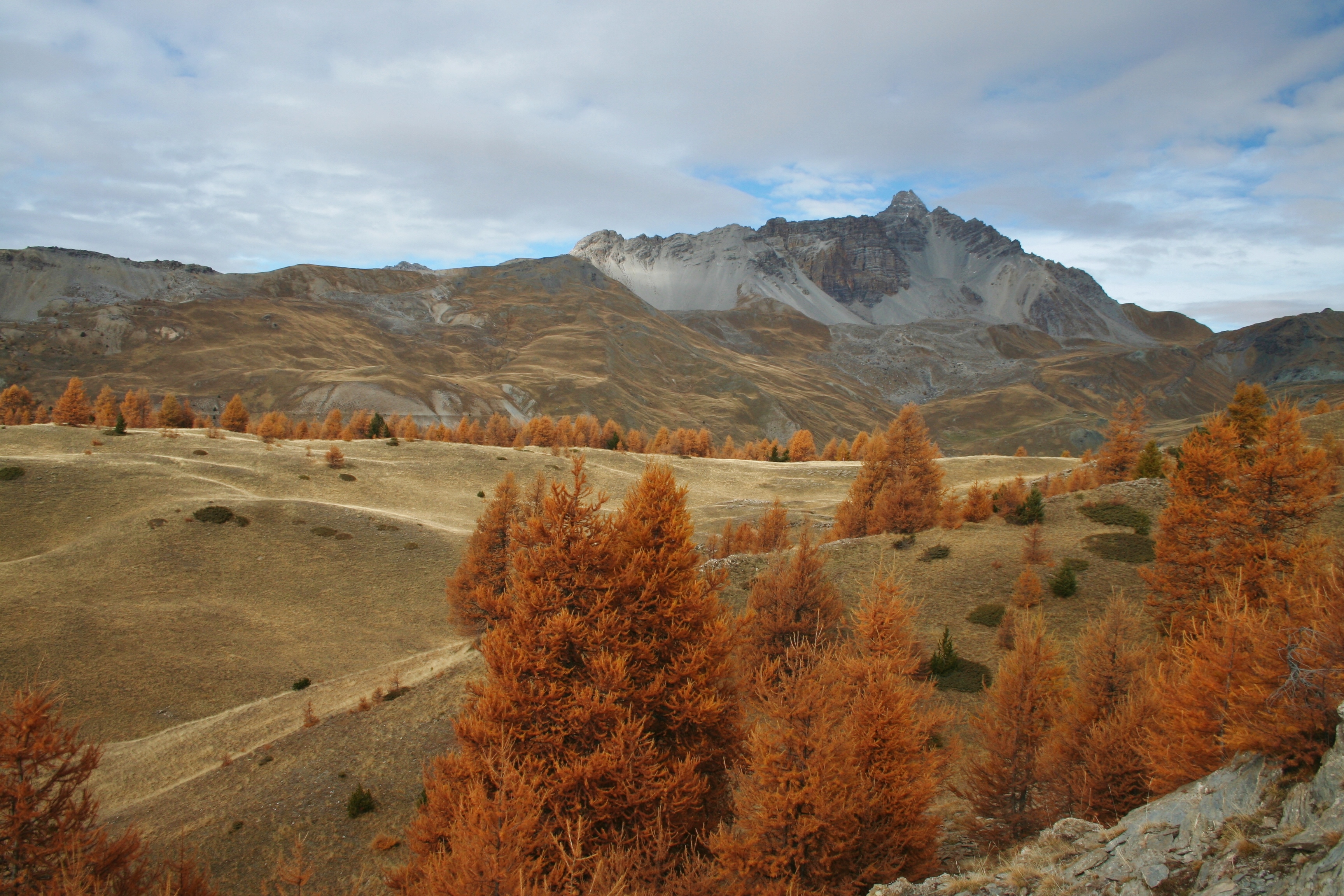
Col de la Crèche
The climb takes place in a forest rich in colour and sounds. Wrens, different chickadees, woodpeckers ... all sing their melodies and cheer up the atmosphere. Once at the mountain pass, the view is fascinating. It covers 180° from Ratier to the Italian border. At the north, the great Rochebrune guards the premises. The peak and its buttresses dominate the valley of Péas and enforce the respect on this valley where herds have been roaming since the dawn of time.
5 points of interest
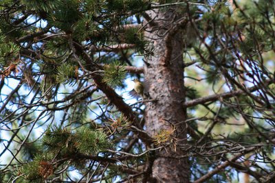
Roitelet huppé - Benjamin Musella - PNR Queyras  Fauna
FaunaThe Goldcrest
The Goldcrest is one of the smallest birds in Europe. It enjoys conifer forests. Hyperactive, it passes from one branch to another, visits a bush, returns to a tree, stays in one place by the speed its wings flap and leaves for foraging. It eats larvae, insects and small spiders. Its presence is related to mild winters. Indeed, the Goldcrest is fragile and a harsh winter would decimate a part of the colony. Conversely, a mild winter would increase the number of individuals.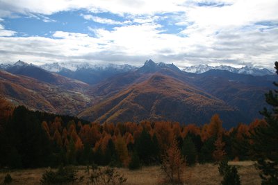
l’Aigue Agnelle - Benjamin Musella - PNR Queyras  Panorama
View when exiting the forest
Just before the Col de la Crèche, the path comes out of the forest and offers spectacular views of the Aigue Agnelle Valley. In the background, the snowy peaks mark the border with the Ubaye on the right and with Italy on the left.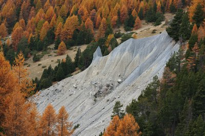
Cheminée de fée - Benjamin Musella - PNR Queyras  Geology
Hoodoo
Fairy chimneys or hoodoos are formed of a column made of sandy and stony brittle layers and a more solid rock that covers the column and ends up falling. Here the cap has come off. So how are these hoodoos formed? Two opposing theories (see mountain bike hiking, the Pierre Dimanche Canal for the second theory). Some geologists believe the cap placed on the column prevents water from coming up by capillary action. This phenomenon promotes the deposition of minerals contained in the water and cements the sediments beneath the protective rock. The columns are therefore already formed in the soil and erosion will gradually discover them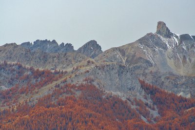
Dent du Ratier - Benjamin Musella - PNR Queyras PanoramaThe Dent du Ratier mountain
The Dent du Ratier mountain overlooks the Arvieux valley to the east and the gorges of the Guil to the south. This distinctive "stump" is a klippe: a piece of rock stuck on different rocks. Indeed, the lower and wooded area consists of shiny schists of Piedmont. As for the upper part, it consists of rocks from Briançon composed of a majority of marble for sign engraving. The stump itself is from limestone placed on a thin layer of schist. These last layers most likely older than the others are the remains of old eroded layers.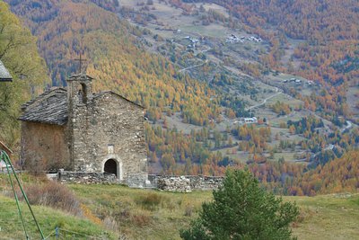
Chapelle Saint Charles Borromée - Benjamin Musella - PNR Queyras  Patrimony and history
Saint Charles Borromée Chapel
Saint Charles Borromée was an italian bishop of the 16th century. He was actively involved in the Catholic reform in struggling against abuses that had developed within the church. In winter, the shepherds of Rouet practised transhumance in Piedmont and Lombardy. That's where they got this saint not very represented in France. The chapel was destroyed during the religious wars in 1548 and rebuilt in 1687.
Description
Go to the end of the parking lot and follow the forest road to Rouet. Take the first track on the right (GR). Continue on the GR to the point Le Puy.
1 - at the oratory, turn left on the path that goes into the woods. Reach a track, turn right and follow it to the point "Platenq la Charpenelle" (1 900m).
2 - Turn left on a wide path that is rapidly shrinking and makes ascending switchbacks. Gradually emerge from the forest and reach a short portion (10m) a little more technical in shale that lead to the Col de Crèche.
3 - Turn right on a level, go around the great slump and turn left directly into the forest.
4 - Enter the pine forest and go down the switchbacks. Reach a wider path, turn right and quickly join the sheep pen of Péas.
5 - Take the left path that reaches Rouet. The trail follows the forest track, except on a short passage from a few metres down this track, and brings you back to the starting point.
- Departure : Les Meyriés
- Arrival : Les Meyriés
- Towns crossed : Château-Ville-Vieille
Forecast
Altimetric profile
Information desks
House of the Queyras Regional Nature Park
3580 Route de l’Izoard, 05350 Arvieux
The House of the Queyras Regional Nature Park is closed to the public.
OTI du Guillestrois et du Queyras
Maison du Tourisme du Queyras, 05350 Château-Ville-Vieille
Transport
05 Voyageur: 04 92 502 505 Tourist Office of Queyras: 04 92 46 76 18
Access and parking
From château Queyras, take the D444 until Meyriés. The car park is located in the village centre on the left. In front ofthe country cottage les Astragales)
Parking :
More information
Report a problem or an error
If you have found an error on this page or if you have noticed any problems during your hike, please report them to us here: