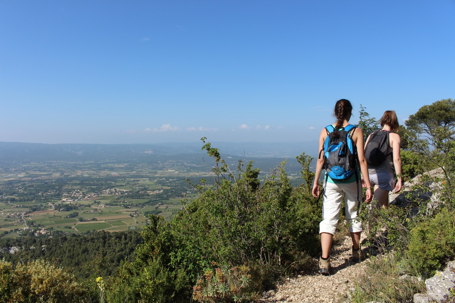
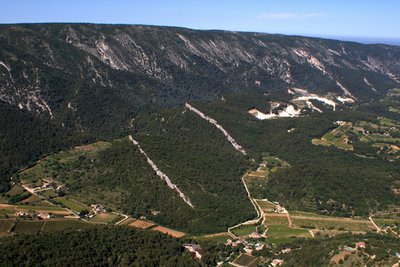
Mourre de Cairas
When leaving Oppède-le-Vieux, an authentic village, the route runs along the shady side of the massif and sandstone outcrops, then gradually rises until the Hautes Plaines and Mourre de Cairas, the highest point of the Petit Luberon (733m). The forest atmosphere gives way to open areas dotted with boxwood, serviceberries and oaks, and finally herbaceous vegetation, place of ancestral grazing. On the way back, the steep and rocky descent delivers spectacular views.
13 points of interest
Terrasses de Sainte-Cécile - ©Destination Luberon  Flora
FloraThe landscaped garden of Sainte-Cécile
Take the time to visit to the north side of the village, the landscaped garden of Saint-Cécile's terraces.! These fifteen dry stone terraces gather more than forty species of trees and shrubs, typical of the country. Shaped like an amphitheatre, it is a real collection of the Luberon jewels over 1.6ha.
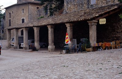
Halle du Vieil Oppède - ©PNR Luberon  Patrimony and history
The covered market
As evidenced by the inscription in one of the stone pillars, this covered market was built in 1772. Located at Place de la Croix and against the rampart, it hosted the meetings of the villagers including fairs. Simple, with an elongated lean-to roof, the care and precision brought to moulded capitals of the pillars is quite noticeable. It was restored in 1991 while missing three spans.
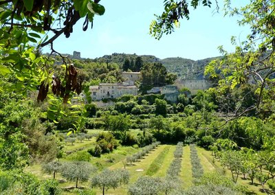
Village de Ménerbes - ©Stéphane Legal - PNR Luberon Patrimony and historyAfar, Ménerbes
Ménerbes, the hillside village you can see in the distance, is worth seeing. On its terraces, the warm atmosphere and the Maison de la Truffe et du Vin (truffles and wine restaurant) is open to experienced gastronomes as those looking to experience some local specialities. You can also see in its plain the vineyards and holm or white oaks that hide the famous black diamond (truffle) at their feet.
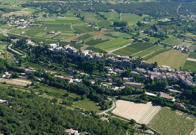
Cuestas du flanc nord du Petit Luberon - ©Stéphane Legal - PNR Luberon  Geology
The Cuestas Oppède
The north side of the Petit Luberon is formed of white limestone called Urgonian. It faces, to the north, a calcareous molasse bar gently sloping, overlooking a steep slope bank. This morphology is called "cuesta" by geologists. Exploited since antiquity, the molasse is always extracted in Oppède and Ménerbes, in open quarries.
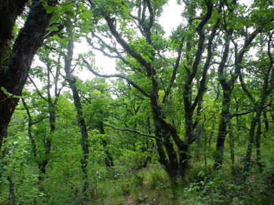
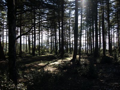
Chênaie sur l'ubac du Petit Luberon - ©Aline Salvaudon - PNR Luberon  Forest
The forest, the source of life!
On the park's territory, the forest occupies 90% of the surface of natural areas. To preserve the balance of nature, biodiversity, cultural heritage and landscape in these forest ecosystems, it is necessary to apply a management that promotes several strata of vegetation, favourable to bats and birds. This forest management must focus on diversification of age classes of trees and species diversity (holm and pubescent oak, pine).
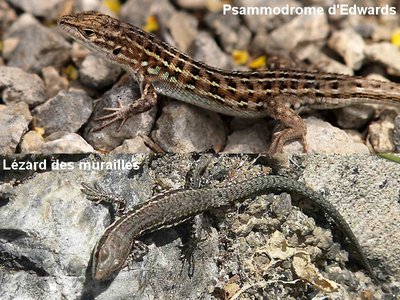
Psammodrome d’Edwards et Lézard des murailles - ©DR  Fauna
FaunaThe Common wall lizard or the Spanish psammodromus?
Strolling through these paths, you can come across a look-alike of the common wall Lizard, tumbling down a bush.. Also brown, the Spanish psammodromus strangely resembles its cousin but when you look closer, it has four dark streaks with black spots on its back. Extremely fast, it likes to hide under dead leaves or sand and screeches when its caught.
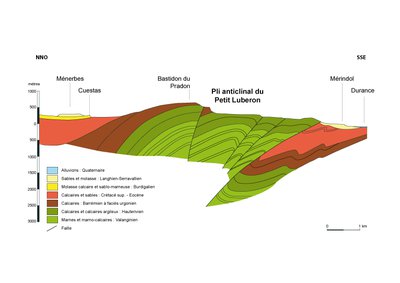
Coupe géologique du Petit luberon - ©DR-D'après M. Liouville GeologyMassif of the Petit Luberon
You are here on the massif of the Petit Luberon which forms an anticline (arch-shaped fold) oriented east-west, between the plain of Cavaillon and the Lourmarin valley. The north side overlooking the Coulon-Calavon Valley and its southern side, the Durance valley, the mythical river of Provence. To the west, on the hills of Bonnieux, the Cedar forest covers the mountains.
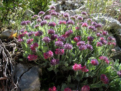
Anthyllide des montagnes - ©DR-Eberhard Scherzler  Elevage et pastoralisme
Steppe grasslands
The lawns of the peaks of the Petit Luberon are open areas rich in biodiversity. The large herbaceous vegetation gives this space an ancestral pastoral calling. The combined action of man and nature provides exceptional biological diversity where there are endemic plant species, reptiles of all kinds or mammals like the Mediterranean pine vole. These grasslands are also hunting areas for large raptors.
Cèdres du Petit Luberon - ©Eric Garnier - PNR Luberon FloraThe cedars in the Petit Luberon
The first cedars were implanted in 1862 with seeds from the Algerian Atlas. Planted by some committed foresters, they were intended to reforest the summit of the Petit Luberon. The cedars of 1st generation found on the Massif des Cèdres near Bonnieux are now 150 years old. The majestic cedars that you can admire in the area are descendants from natural colonization and form the forest today.

Petit refuge du Bastidon du Pradon - ©DR - refuges.info Patrimony and historyThe Bastidon Pradon
The small unguarded hut you will see is called "Bastidon Pradon". Open to hikers or passing riders, it is freely available. Inside, no mattresses or blankets but enough dishes to eat and warm up. Perfect for a break or a step, the days of big mistral!
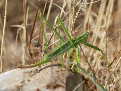
Magicienne dentelée - ©Laurent Michel - PNR Luberon FaunaThe Spiked Magician
The Spiked magician (Saga pedo) is the largest bush cricket in France and among the largest insects. It may indeed measure up to 11cm. Very discreet, it enjoys the dry grassland and scrubland of southern France that we see here. Rather a rare fact, there is no male of this species. The females reproduce with parthenogenesis (asexual reproduction) and the offsprings of each female are therefore clones.
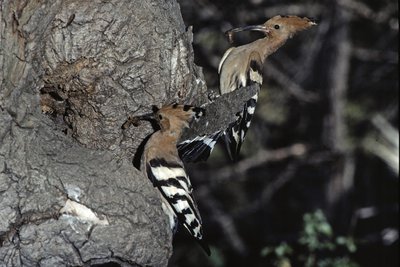
Huppes fasciées près de leur nid - Claude Tardieu FaunaOld forests and tree sheds
Here the atmosphere is special, and the ecological wealth is striking. A true social housing moss and fungi, older trees host a multitude of inhabitants; birds, insects, or bats ... In the cracks of branches, holes drilled by woodpeckers or under the ivy, they nest or flush out wood-eating insects (xylophagous). The flora of the understory is also original. These old forests are precious.
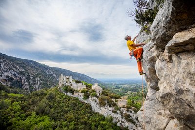
Escalade sur le secteur Dent du Loup - ©Pierre Duret Patrimony and historyHere, it's all about climbing!
To the right, above the path, lies a small rock climbing schoolpopular with climbers from all around the country. Itcontains about forty routes with difficulty levels ranging from 3a to 7b, fitted on limestone slabs over 16m. Located at the limit of the biotope protection, it is the only site open to climbers on the Petit Luberon. All the other cliffs are closed to climbing practices in order to preserve the tranquillity of raptors.
Description
From the Place de la Croix, go along the halls, keep walking and turn left on Rue de l'Ecole". Turn right and reach below the Chemin de la Fontaine (GR).). Take the road on the right.
1- At the crossroads'Poudarrigue'', leave the GR and continue left on Chemin de la Perrière. 800m further, when at the second house, take a right (RP). Reach a flat area, join the valley and continue to the left. Cross the collar of Ribas de Pire and down the slope,take a left.
2- At the track crossroads , turn right (RP), pass more then three homes and cross the collar of Grimouret. Down the steep path, continue right and quietly up the floor of the valley.
3- At the crossroads'Poudarique' ', turn right and climb the trail to Mourre de Flamarin (RP). After a curve to the left, go forward on the flat area and reach the paved forest path.
4- Turn right and proceed 400m, pass the hilltop of the Mourre de Cairas (733m) on the right and continue on the track for 1.5km.
5- At the crossroads'Bastidon Pradon' turn to the left in the undergrowth and reach the small refuge that is 150m away. Retrace your steps to point 5, cross the forest track and go straight to "l'épaule de la Jassine" (GR). Then switch to the slope, cross several curves and reach a little collar lower down. Continue on the left, pass below the Ribas de Brécugne (climbing school site) and reach the chemin de la Fontaine.
1- Go back Place de la Croix through the path used at the start (GR).
- Departure : Place de la Croix, centre of Oppède-le-Vieux
- Arrival : Place de la Croix, centre of Oppède-le-Vieux
- Towns crossed : Oppède, Ménerbes, and Cheval-Blanc
Forecast
Altimetric profile
Recommandations
- Après le point 5 : balisage peu évident sur les parties dénudée du plateau des Hautes Plaines ; s'aider des caïrns disposés le long du sentier. Et attention aux chevilles dans les zones calcaires érodées (lapiaz).
- Sur les crêtes, entre les points 4 et 5, et allentours : ATTENTION ZONE PASTORALE. En présence de chiens de protection venus à ma rencontre, je ne les caresse pas ni ne les menace. Je m'arrête, puis j'attends patiemment la fin du ''contrôle'' avant de reprendre calmement mon chemin en contournant le plus possible le troupeau. De préférence, ne pas emmener son chien et, sinon, bien le tenir en laisse.
Information desks

Luberon UNESCO Global Geopark
60, place Jean Jaurès, 84400 Apt

House of the Luberon Regional Nature Park
60, place Jean Jaurès, 84400 Apt
In the heart the old town centre of Apt, the House of the Luberon Regional Nature Park welcomes you in a town house of the 18th century. The permanent exhibition of the geology museum has a rich collection of fossils evidencing the geological history of the Luberon.
On sale at the shop: books, maps, guidebooks, games, posters...
Open Monday to Friday from 8:30 am to 12:00 pm and from 1:30 pm to 6 pm (and on Saturday, depending on the program). Free admission.

OTI Luberon Coeur de Provence
Place François Tourel, 84300 Cavaillon
Access and parking
A 11 km à l'est de Cavaillon, par les D973, D2 et D29.
Parking :
Source

Report a problem or an error
If you have found an error on this page or if you have noticed any problems during your hike, please report them to us here: