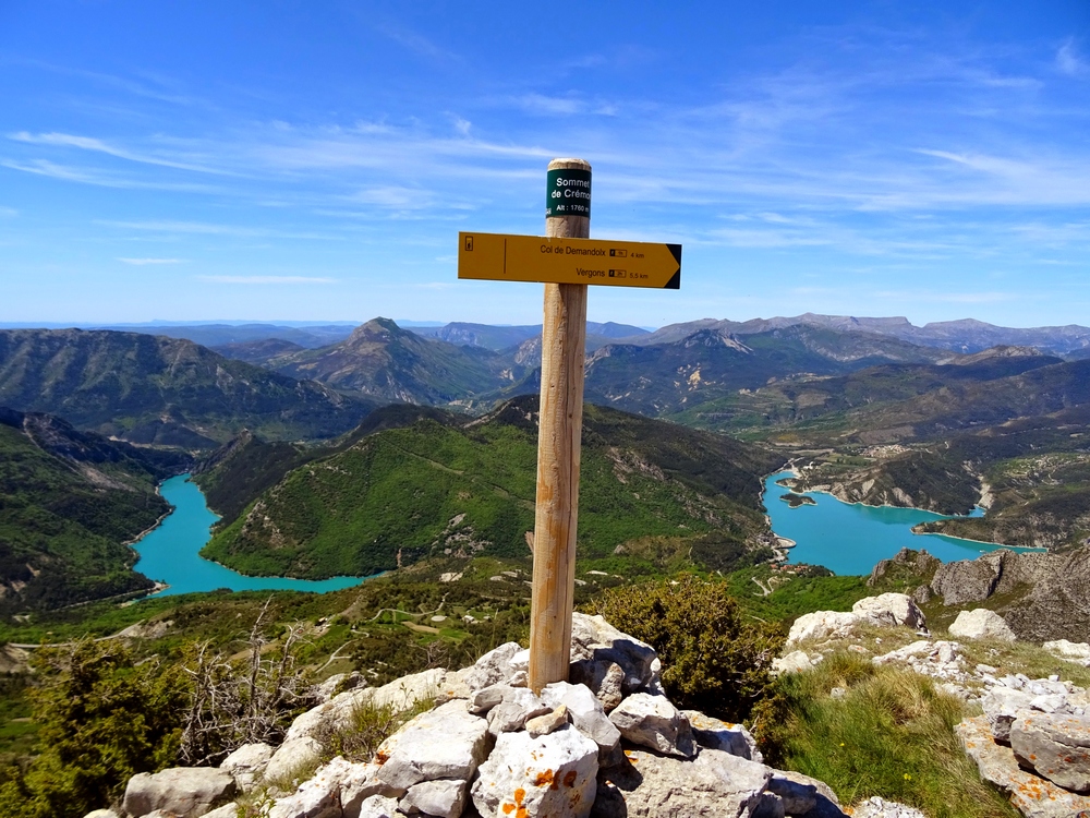
The peak of Mount Crémon
Early morning on a clear day, you can see from the top of Mount Cremon (1760m) Corsica, the gap from the Gorges of Verdon in the southwest and Mount Chiran with the observatory of Haute-Provence in the west.
1 point of interest
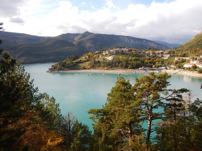
Saint Julien du Verdon - Stefano Blanc - PNR Verdon  Patrimony and history
Saint Julien du Verdon
The contemporary village of Saint-Julien is located only 9km from the capital city of Suetrii called Ducelia, then Salinae, the ancient city of Castellane. An ancient pre-Roman road linking Cimiez to Riez via Annot and Entrevaux crossed the lower area of the town, now submerged under the waters of the lake. The section linking Vergons (capital of Vergunii) to Castellane crossed the Verdon, between Saint-Julien and Castillon, with a bridge strangely named the Julien bridge.
Description
1 - Take the trail rising above the road heading to Mount Crémon, across the picnic area. When coming out on a track, follow it at the rise, following a hairpin bend to the right. After 100m, take the left path. stroll under the pines and reach the track again (cross it). Then the climb becomes less steep. Follow the track under the larches and reach a large flat area at the border between the sunny and shaded slopes (a spring below, behind the slope of the track).
2 - Follow the track across for 50m, then exit it to the left and take a trail rising regularly in the slope parallel to the track. After crossing two ravines and following some hairpin bends, come out on the Demandolx mountain pass at 1.5km.
3 - At the mountain pass, follow the trail to the left for 1 km / less than a mile. Then leave it when reaching the right slope. Stroll along the route which remains flat for a good while. Reach the ridge of Mount Crémon.
4 - Leave the main trail and turn right onto a narrow path. Follow the route through the ridge and climb to the top. Perform the last 400m of vertical drop first in the undergrowth and then in the pastures. To the top of Mount Cremon at the mountain pass cycling milestone (1760m).
5 - The same route is used for the return.
- Departure : Picnic area D955, Saint Julien du Verdon
- Arrival : Picnic area D955, Saint Julien du Verdon
- Towns crossed : Saint-Julien-du-Verdon, Demandolx, and Vergons
Forecast
Altimetric profile
Recommandations
Avoid high summer temperatures, leave early. We recommend: 2L of water per person, a hat and proper hiking shoes. An abyss at the ridge of the western slope.
Information desks
House of the Verdon Regional Nature Park
Domaine de Valx, 04360 Moustiers-Sainte-Marie
House of the Verdon Regional Nature Park

OT Castellane
Rue Nationale , 04120 Castellane

OT Saint André les Alpes - Barrême
Place Marcel Pastorelli, 04170 Saint-André-les-Alpes
Transport
Access and parking
At 1.5km south of St-Julien-du-Verdon, along the D955 (Castellane road), picnic area
Report a problem or an error
If you have found an error on this page or if you have noticed any problems during your hike, please report them to us here: