Véroncle in its entirety
« After the lessons on the Bories, on the Gordes, here is another lessonon rural engineering.! At the time the castle of Gordes was being built, qualified with the lovely word as Renaissance, men brought stones down to build wells to trap the precious fluid and to make the windmills turn in the meandering of the Gorges of Véroncle. It was indeed the start of a new world.». According to J.P. Locci and D. Lacaille Association for the promotion and the preservation of industrial heritage in Vaucluse.
19 points of interest
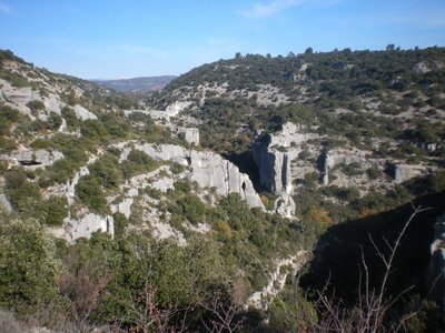
Gorges de Véroncle et Mont-Ventoux - ©Eric Garnier - PNR Luberon  Geology
Gorges de Véroncle
The water flow between the collapsed ditch of Murs located on the heights of the limestone plateau and the Apt basin downstream, dug this impressive canyon called "raccordement". Then the corrosive action of rain water containing carbon dioxide has gradually, through dissolution, enlarged cracks to create true underground networks. The Gorges de Véroncle are not used or hardly used by water, but contain an amazing industrial heritage.
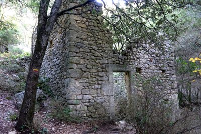
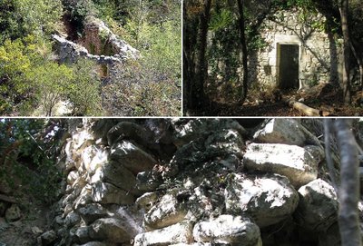
Moulin des Grailles (privé ne se visite pas) - ©Eric Garnier - PNR Luberon  Patrimony and history
The Grailles mill
There are a few remains of this mill dating from the 16th century, deeply restored and transformed into a dwelling. Beyond the changes, it is similar in its operation to the Cabrier mill upstream and constitutes one of the last of the 10 mills along the Véroncle.
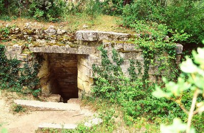
Moulin Cabrier - ©Eric Garnier - PNR Luberon Patrimony and historyMoulin Cabrier
Dating most probably from the 16th century also, this milldid not have a dwelling unit. Given the modesty of the building, the hydraulic device upstream is spectacular. The pipe carved on the side of the rock comes out on a triangular well in ashlar stone. It is fed by a substantial resclause (small reservoir upstream) partly under rock. In 1874, the owner then built a dam across the Véroncle to increase his water reserves.
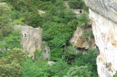
Moulin Jean de Marre II - ©Eric Garnier - PNR Luberon Patrimony and historyJean de Marre II mill
This mill probably dates back to the 16th century. The building is simple in form: a water chamber partially collapsed and the grinding room above. Special feature of the site, the resclause (water supply) is quite far from the mill. Also, in order to emphasise the waterfall effect, a vertical well was used in way of the water chamber. Like all the mills of Gordes and unlike those of Murs, they did not belong to the Lord but to several private owners.
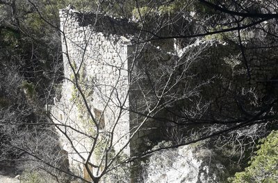
Moulin Jean de Marre I - ©Eric Garnier - PNR Luberon Patrimony and historyJean de Marre I mill
It is the first mill of Gordes. Built in the 16th century, it was expanded in the 18th century, as evidenced by the collages of masonry. It is a more complex construction on 4 levels: the water chamber, the grinding room, the sack floor and the dwelling (you can still see a fireplace and a sink). In the 19th century, an independent farming developed with arable lands, vineyards, mulberry trees, olive trees, almond trees, pigs, chicken coops.
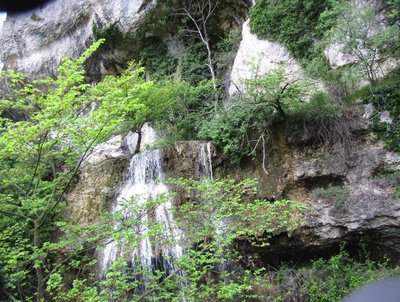
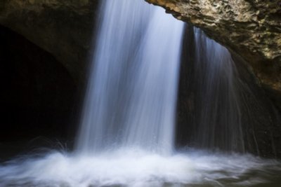
Cascade de tuf - ©Georges Guende - PNR Luberon  Flora
FloraThe tuff waterfall
The waterfall, where the Jean de Marre I mill was strategically located forms also a beautiful natural curiosity called tuff! Product of dissolved limestone redeposited, having captured plant and animal debris, the tuff is a very tender and friable rock. When the river is not dry, it is home to lush mosses and ferns particularly enjoying the saturated humidity of the place. This habitat is still rare and located in Provence.
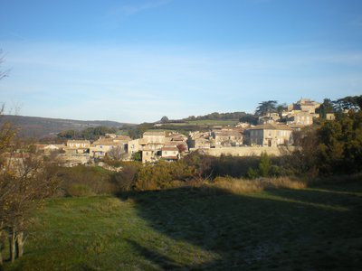
Village de Murs - ©Françoise Delville - PNR Luberon  Panorama
Here, time stops...
Between Ventoux and Luberon, this wooded limestone massif opens onto rare agricultural parcels. Contemporary human presence is discreet but the wealth of the dry stone heritage is a reminder of its historical presence. A network of winding roads and ancient mule tracks serve the hilltop villages alongside the massif. These roads, dotted with remarkable oaks, reinforce the bucolic character of this countryside that seems frozen as if it was timeless.
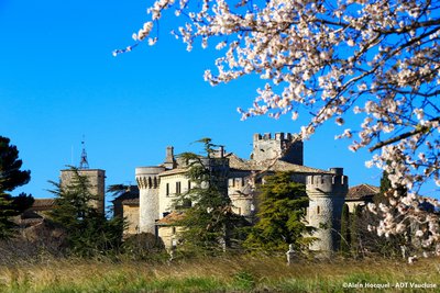
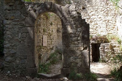
Château de Murs - ©Alain Hocquel - VPA Patrimony and historyThe castle of Murs
It was around year 1.000 that the land of Murs is given to the Agoult family who will build a castle. For four centuries, it was mainly a stronghold for the soldiers of the lord and the dungeon was then built there. After the Agoult family, came the weapons of the Astouaud family which you can see on the castle gate. The church was built in a Romanesque style in the 12th century inside the castle. The building is private and therefore closed to the public.

Louis de Berton des Balbes dit Crillon le Brave - ©DR Patrimony and historyCrillon le Brave, life of a warrior
At the heart of the village of Murs hides the birth house of Crillon le Brave, born in 1543. Born Louis de Berton des Balbes, he will then become Crillon and will continue to wage war. He accompanied 5 kings of France, Henri II, François II, Charles IX, the Duke of Anjou who became Henri III, and it was Henri IV, his comrade, who gave him the name Brave Crillon. His life was made of battles, wounds and victories. He died in 1615 in Avignon, a victim of his countless injuries.
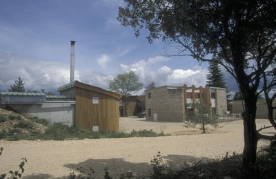
Chaufferie bois-énergie de Murs - ©Hervé Vincent  Savoir-faire
First wood fuel boiler of PACA
All of Remourase houses the very first collective energy wood boiler in the Luberon ... and even in the region! Established in 2000 during the redevelopment of a former holiday camp, it can heat 6 public housing, a lodge, a community hall and 5 local professionals. It is a renewable energy that contributes to the maintenance and the enhancement of the forest land. Since then, more than 40 boiler rooms of this type were carried out in Luberon.
Début du fossé d'effondrement de Murs - Françoise Delville - PNR Luberon GeologyThe ditch of Murs
The village of Murs dominates to the southwest a depression occupied by farmland. These grounds fit perfectly with the limestone and clay outcrops bordered by an imposing limestone mass. About 35 million years ago, during the Oligocene, deep fractures (faults) outlined a zone which sunk gradually: a Graben (german for ditch). This is the story of the ditch of Murs, which is also the story of Sénanque ...
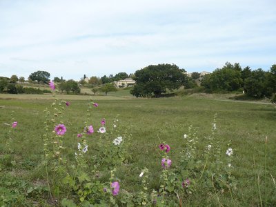
Prairies humides de Murs - ©Jérome Brichard - PNR Luberon  Water and rivers
Grasslands of Murs
Until the late 19th century, 15ha of natural hay meadows and pastures of this valley floor were partly submerged by the dam water feeding the mills of the Gorges. Today, these grasslands are wetlands, biodiversity supports, which fill the role of water storage, purification, protection against soil erosion and the run-off of the stream. They also have an important place in the local agricultural economy which is based on livestock.
Moulin Jean de Marre I - ©Eric Garnier - PNR Luberon Patrimony and historyThe mills of Véroncle
Since the imposing dam placed on the ponds (now filled in) from the village of Murs to the Hameau des Cortasses, about ten flour mills operated from the 16th to the mid 19th centuries. Despite the places hard to reach, following along the ravine are amenities of a rare quality,: penstocks and channels carved in the rock, reservoirs and retaining walls.
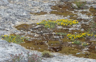
Genêt de Villars - Laurent Michel - PNR Luberon FloraSmall garrigue (scrubland) in Genêt de Villars
On this arid hillside, you can see a discreet broom (shrub) against the ground: Villars broom (Genista pulchella subsp. villarsii). Its meagre look is an adjustment to sunny and dry environments: It sweats very little! While fearing competition from other species, he deigns to share its habitat with few neighbours hand-picked, like here, Perennials (Minuartia capillacea) family of carnations with beautiful white flowers.
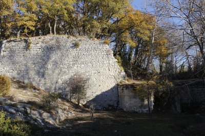
Ruines du barrage des étangs - ©Jérémie Haye - PNR Luberon Patrimony and historyThe dam of the pond
Built in the 16th century, This large tank was used to supply the first three mills of the Gorges belonging to the Lord of Murs. It also served as a fishing reserve. Remodelled several times over the centuries, it no longer works nowadays but remains in place. Two parallel walls 80m long held back a pile of earth forming a earth-fill dam. On a quoin, we can see a badge dated 1584 which could be a date of remodelling of the building.
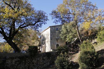
Moulin des étangs (habitation privée, ne se visite pas) - ©Jérémie Haye - PNR Luberon Patrimony and historyMoulin de l'Etang
First mill of the Gorges and located on the lands of the Lord of Murs, the current building was probably built in the 16th century, as evidenced by the date 1581 on the lintel of a door. It was probably enlarged in the 18th century and more recently converted into a private housing. Initially, it operated with an horizontal wheel turned into a vertical wheel at the end of the 19th century. It was fed by a resclause (small reservoir upstream) located near the old pond.
Vestiges du moulin du Dévissé - ©Eric Garnier - PNR Luberon Patrimony and historyMoulin du Dévissé
It is the second mill of the Gorges in Murs. Also built in the 16th century as indicated by the year 1573 engraved on a stone from the entrance door, it is now in ruins. It was fed by a béal (channel) which is none other than a leak of the mill of the pond. Today, we can only make out the grinding room which is in flint. Below stood the water chamber today obstructed, and above, the dwelling of the miller.
La canon en pierre de taille - Jérémie Haye - PNR Luberon Patrimony and historyMoulin de la Charlesse
The third mill of the Gorges in Mursit is based on the same construction principle as the first two (a water chamber which is under the grinding room and the dwelling). The year 1753 is engraved on a stone corresponds most likely to the year of remodellingthan the initial construction. Here, we can easily distinguish the cannon in ashlar stone which allowed to create a waterfall and so a driving force between the resclause (small reservoir upstream) upstream and the water area below.
Véroncle en crue ! - ©David Tatin Patrimony and historyMillers of all trades!
As of the 19th century, the lack of water and the inability to operate the mills of Véroncle more than two months in the year are being noticed. So to adjust to this, millers had to find other sources of income. This is how they started small farming units, mixed farming, firewood or silkworms! And when water would refuse to flow well in the Gorges again, the millers would return for a while to their milling business.
Description
From the car park, go left on the D15 for 300m. Take the path to the right.
1 - Go straight and down the long flat area of Vézaule. Further down, leave the left path behind and reach into the Gorges and the windmill of Grailles (private property, cannot be visited).
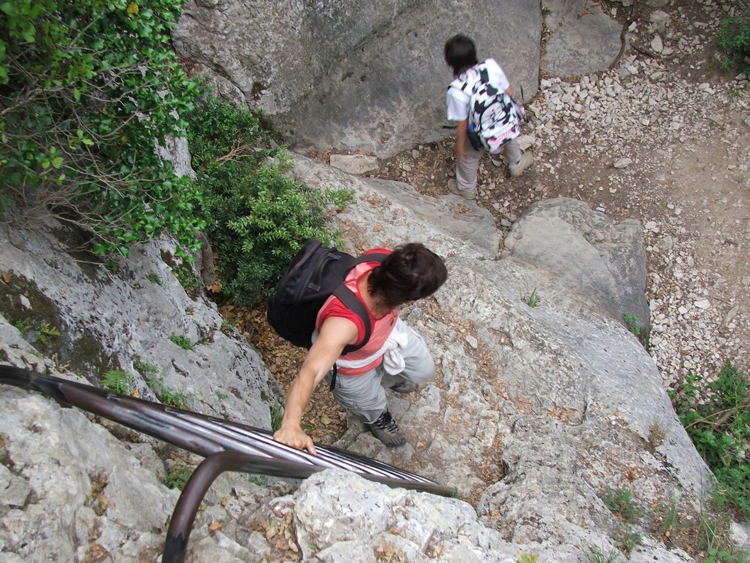
2 - Retrace your steps and 60m further, take a right at the bottom of the ravine. Reach the Cabrier windmill. Weave along the wall to the left, cross a narrow balcony passage, then pass through the water carrying canal. Climb a first ladder, pass a ledge and continue alternating between the two banks. Higher up, cross a rocky ledge (handrail), then move left to rise. Pass a flat area and go down to the right. Go left to the bottom of the Gorges. Pass the Jean de Marre windmills (I and II) and then reach the crossroads upstream.
3 - Go up some 30 metres upstream until a rocky slab. Do not climb the steep path to the right but continue on the one that runs along the river bed. 200m further after a little ledge, cross a ford, take the path on the opposite bank in the downstream direction. Climb two stony steep paths, reach the old track and continue climbing the milder slope. Reach the plateau and continue the path until the track.
4 - At the crossroads ''Lauzière'', follow the left path. Pass two turns and continue on the small road. At the crossroads, continue left. Reach the D4 (calvary), turn left and reach Murs.
5 - At the crossroads between the D4 and the D15, exit to the left on the small road. Lower down, go onto the opposite track. 700m further, do not miss the start of the trail to the right. Go down two rocky hairpin bends, go past the Moulin des Etangs (private property, cannot be visited). Continue onto the valley floor. Pass the Devissé windmill and continue going.
6 - In front of the Charlesse windmill and its penstock, continue at the bottom of the Gorges to the left. Make a detour to the right to reach the foot of the ledge of the mill of the Cata well. Continue at the bottom of the Gorges and reach the path taken to go.
3 - Turn right and climb the hairpin bends. Continue on the balcony path. At the crossroads "Vezaule", continue left.
2 - Turn right and return to the starting point following the route taken to go.
- Departure : Car park along the D15A, 2km north of Gordes
- Arrival : Car park along the D15A, 2km north of Gordes
- Towns crossed : Gordes and Murs
Forecast
Altimetric profile
Recommandations
Do not engage in the downstream part of the route after a storm or rainy weather; some ravine bottom passages can be very difficult, in fact dangerous!
Also in the downstream part, be very careful when crossing more or less airy ledges (ladder, handrail).
Caution with your ankles on rocky and slippery passages at the bottom.
Information desks

Luberon UNESCO Global Geopark
60, place Jean Jaurès, 84400 Apt

House of the Luberon Regional Nature Park
60, place Jean Jaurès, 84400 Apt
In the heart the old town centre of Apt, the House of the Luberon Regional Nature Park welcomes you in a town house of the 18th century. The permanent exhibition of the geology museum has a rich collection of fossils evidencing the geological history of the Luberon.
On sale at the shop: books, maps, guidebooks, games, posters...
Open Monday to Friday from 8:30 am to 12:00 pm and from 1:30 pm to 6 pm (and on Saturday, depending on the program). Free admission.

OTI Luberon Coeur de Provence
Place François Tourel, 84300 Cavaillon

OTI Pays d’Apt Luberon
788 avenue Victor Hugo, 84400 Apt
Du 1er avril au 30 septembre
Ouvert du lundi au samedi de 9h30 à 12h30 et de 14h à 18h.
Juillet et août : Ouvert dimanche et jours fériés de 9h30 à 12h30
Du 1er octobre au 31 mars
Ouvert du lundi au mardi et du jeudi au samedi de 9h30 à 12h30 et de 14h à 18h.
Fermé le mercredi, dimanche et jours fériés.
Access and parking
At 18km northeast of Cavaillon, through the D15.
Parking :
More information
Source

Report a problem or an error
If you have found an error on this page or if you have noticed any problems during your hike, please report them to us here: