The Aiguiers (cistern from rock) of St-Saturnin-lès-Apt
« The traveler who crosses the Monts-de-Vaucluse does not suspect that arid hills looming on the horizon are also the land of endless valleys, silence, where one can walk for days without seeing another soul. To the one who penetrates its secrets, the country of aiguiers will reveal its own-value.; made of dry stone, scarce water and precious greenery...». FrançoisMorenas (1917 - 2006), innkeeper, itinerant filmmaker, writer and a trail clearer.
7 points of interest
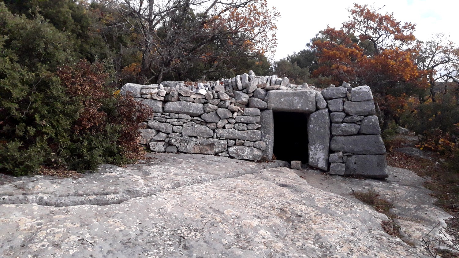
Aiguier couvert de Barralié - ©Eric Garnier - PNR Luberon  Geology
The Aiguiers
"The northeast of Saint-Saturnin-lès-Apt is named this way because many farms there only had one water supply which was a cistern dug in the limestone and fed by rainwater through a water-collecting system (impluvium)."
From the book "Saint-Saturnin au fil du temps"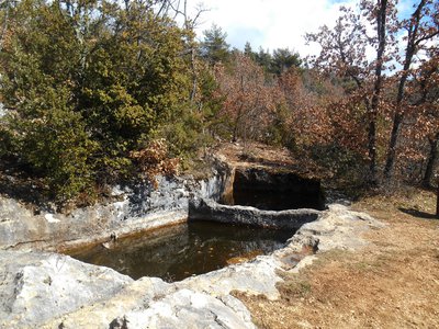
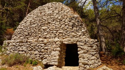
Aiguier ''jumeaux'' de Bessons - Marie Grenouilleau - PNR Luberon  Elevage et pastoralisme
The Aiguiers (underground tanks)
On the hills of Saint-Saturnin-lès-Apt, men have built and maintained many aiguiers (Provençal term for"aigo" meaning water). These basins dug into the limestone and fed by rainwater by an ingenious system of recovery of run-off water, have long allowed the maintenance of rural housing and the watering of cattles on arid land.
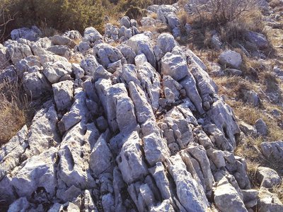
Lapiaz du Cluyer - Eric Garnier - PNR Luberon GeologyGroove, channel, I am ...
the lapiaz (limestone pavements).! On cliffs, you can see grooves, ridges saturating the rock. These are "lapiés" or "lapiaz" in the singular form. The rainwater has eroded the rock by a process of dissolution to dig the channel in the limestone. The water which continues to rush into these grooves feeds the underground springs.
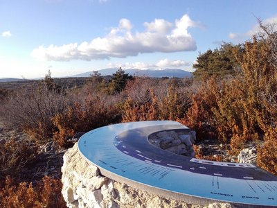
Mont-Ventoux depuis le Cluyer - ©Eric Garnier - PNR Luberon  Panorama
The treasure hunt of underground tanks
Between Ventoux and Luberon, this wooded limestone massif is the witness of an ancient human presence. A real treasure hunt will guide you through the mountains to discover a rich heritage of stone, associated with the collection and storage of water. In contrast, the open view of the Calavon valley shows a more contemporary human activity: recent urbanisation of villages, agricultural activities in the plain ...
Aiguiers de Travignon - ©William Fautré  Patrimony and history
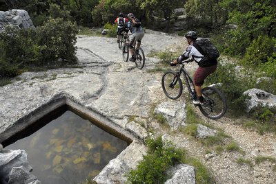
The country of Apt, Saint-Sat', land of mountain biking
The country of Apt, at the heart of the Luberon, has always been a renowned spot for mountain biking. Many bikers have tested their bike ranges on the rugged trails. In winter, the southern slopes of the Monts-de-Vaucluse, above Saint-Saturnin-lès-Apt, proves to be one of the best places to ride in the dry area, mud-free and protected from the mistral. The Grande Traversée VTT of Vaucluse passes through here, starting from the northern side of Ventoux and towards the Luberon until Mérindol (400km).
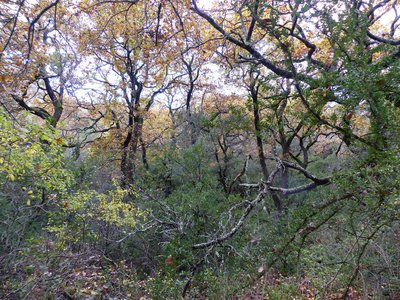
Chênaie blanche à l'automne - ©Laurent Michel - PNR Luberon  Flora
FloraThe White Oak
White Oak, also known as Downy Oak is a deciduous species, unlike the Holm Oak. It enjoys the cool conditions of the valleys and higher altitudes. It is accompanied by the Shadbush, the Estrusque Honeysuckle, the Whitebeam ... In the Combe de Travignon, the forest is old, and has been exploited for centuries to provide fuel and charcoal.
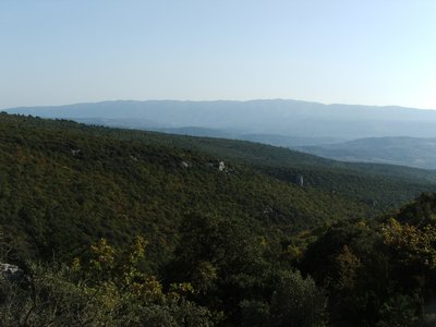
Chênaie verte du vallon de Travignon - ©Eric Garnier - PNR Luberon FloraThe Holm Oak
On the southern slopes of the Monts de Vaucluse, the Holm Oak (Evergreen Oak) occupies the lower altitudes, from 200 to 700m.. This forest is in the form of brush, remnants of an intensive operation system which provided firewood or charcoal directly, manufactured on site in charcoal burners. The Holm Oak is accompanied by distinctive shrubs: Mock Privet, Buckthorn, Montpellier Maple ...
Description
Back facing the car park, go down across on the paved track. After the turn; go back up gently. At the 1st intersection, turn left and climbthe track. Leave behind several roads to the right then to the left leading to houses. Pass a sloping ledge and reach the Aiguiers Bessons.
1 - Rise to the right onto the path. At the 1st crossing, continue the winding paths across (new variant). At the path, still continue across. A little further, leave a track going to the right and continue on the rocky ledge. Reach a viewpoint and climb the edge to the east (marking hardly noticeable). Reach a small covered aiguier. Continue to the right, pass the orientation table and reach the Cluyer dome (mountain pass cycling milestone).
2 - Descend the trail due north, continue on the path under the pines and come out on La Liguière track. Follow right on 150m and take on the right the Lays track (ignore the sign'Sentier des Aiguiers'' to the left). Reach the Romanet track and go down to the right for 500m, then at the exit of a bend, turn left towards Travignon. After a ledge in the woods, turn left.
3 - Continue the path straight. Pass 2 turns and reach the Aiguiers upstream. Retrace your steps to point 3 by cutting through 2 turns by the stony path. Turn left and cross the ruins of Travignon. When leaving the hamlet, take a sharp right and immediately a left to go down the winding paths of the old mule track. When at the 2 large rocks, leave the GR® behind to the left and go down the path to the right. Go up slightly to come out on the Romanet track. Go down on the left for 1km / less than a mile.
4 - Do not miss the path that rises to the right (point 754m). 200m above, turn left and climb the path. Continue by following the marking carefully (private property!), then gradually rise to a track that leads to the Caulet farm. Go down to the left, go up slightly, then turn left (mountain pass cycling milestone).Go down the path to the south. Do not miss, at the exit of a corner, the trail rising to right and coming out on the corner of a fence. Turn left, walk along the fence and come out on the Romanes trail. Turn left to return to the starting point.
- Departure : Leave the Longuets along the D230, 5km north of Saint-Saturnin-lès-Apt
- Arrival : Leave the Longuets north of Saint-Saturnin-lès-Apt
- Towns crossed : Saint-Saturnin-lès-Apt
Forecast
Altimetric profile
Recommandations
Caution with your ankles while going across the rocky area (limestone pavement) of the Cluyer dome.
Do not enter the ruins of Travignon; risk of collapse!
Respect the tranquillity, the ancestral heritage and properties (some Aiguiers and Bories are private).
Refrain from picking mushrooms and do not enter the truffle zones.
Although the hiker always has priority, stay alert when approaching bikers, very present on the paths of the area.
Information desks

Luberon UNESCO Global Geopark
60, place Jean Jaurès, 84400 Apt

House of the Luberon Regional Nature Park
60, place Jean Jaurès, 84400 Apt
In the heart the old town centre of Apt, the House of the Luberon Regional Nature Park welcomes you in a town house of the 18th century. The permanent exhibition of the geology museum has a rich collection of fossils evidencing the geological history of the Luberon.
On sale at the shop: books, maps, guidebooks, games, posters...
Open Monday to Friday from 8:30 am to 12:00 pm and from 1:30 pm to 6 pm (and on Saturday, depending on the program). Free admission.

OTI Pays d’Apt Luberon
788 avenue Victor Hugo, 84400 Apt
Du 1er avril au 30 septembre
Ouvert du lundi au samedi de 9h30 à 12h30 et de 14h à 18h.
Juillet et août : Ouvert dimanche et jours fériés de 9h30 à 12h30
Du 1er octobre au 31 mars
Ouvert du lundi au mardi et du jeudi au samedi de 9h30 à 12h30 et de 14h à 18h.
Fermé le mercredi, dimanche et jours fériés.
Access and parking
At 9km from Apt, the D900 and D943, and the D232 after 5km above Saint-Saturnin-lès-Apt.
More information
Source

Report a problem or an error
If you have found an error on this page or if you have noticed any problems during your hike, please report them to us here: