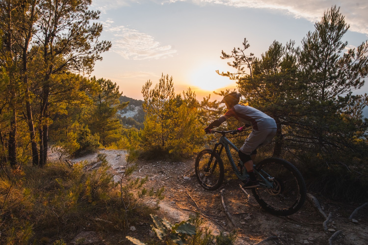
Colorado tour by mountain bike
« The heartof the classified site of the ochres of Rustrel, very popular and particularly fragile, is reserved for visitors on foot. But by mountain biking, the tour of the Provençal Colorado massive,embellished with the crossing of the smallochry block of La Bruyère, allows full use of atypical colourful land but also to enjoy beautiful views from the ridges or through the Monts-de-Vaucluse. A magnificent loop, a must-see! ». Eric Garnier Head of Studies for outdoor sports at the Luberon RNP.
19 points of interest
Colorado de Rustrel - ©Daniel Grenouilleau  Patrimony and history
Opération Grand Site Massif des Ocres
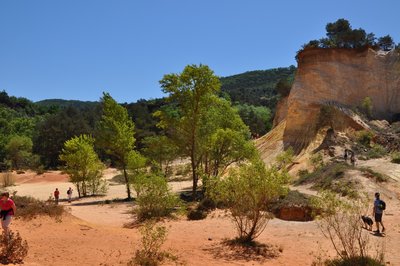
Classified site since 2002, the ochres of Apt are one of the largest deposits in the world. With a significant number of visitors and risks of degradation, the Massif des Ocres raises lots of questions. In 2010, working in tandem with local actors, an "Opération Grand Site" (sustainable Tourism project) was launched to implement a development project, good management and preservation of natural and landscape heritage but also cultural heritage in the hope of becoming a "Grand Site de France".
Palette de couleurs - ©Vincent Damourette - Coeurs de nature-SIPA  Geology
Ochre formation
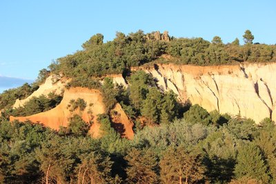
The ochre sands result from a deep chemical modification of green marine sands. About 100 million years ago, green sands emerged and were altered under a hot and humid climate which transformed into, amongst others, ochre sands. It is from these sands extracted in quarries that ochre is made. Warning, mountain biking in the heart of the Provençal Colorado in Rustrel is forbidden, as is the sampling of ochre sands in natural environment.
Traces de l'exploitation de l'ocre - ©Rémi Duthoit  Savoir-faire
Ochre processing in Rustrel
The Provençal Colorado is an old ochre operating quarry which dates back to the 19th century. The distinctive feature of the extraction is the use of water which served for washing the excavated faces. The sands were then dissolved and rolled down the slopes to the settling ponds. The remains from working the ochre are still found today on the site as an aqueduct, a network of pipes, pumping machines, drying ponds ...
Peupleraie de la Dôa - ©Eric Garnier - PNR Luberon  Forest
Banks and rainforests
Mainly located along the Doa, an alluvial forest of softwood (like th poplar) has settled in connection with the layer of the river. They play many biological roles, namely, maintaining the banks, the self-purification of water, a reservoir and an ecological corridor for many species. They are a breeding and feeding hub for many species of birds and insects.
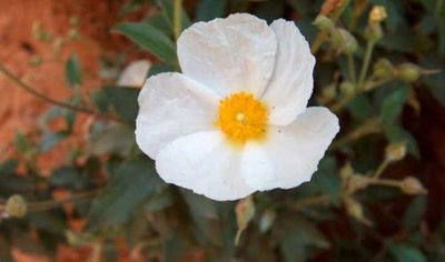
Ciste à feuille de lauriers - ©DR-Ecobalade  Flora
FloraThe laurel leaved Rockrose
The laurel leaved Rockrose (Cistus laurifolius) is an easily identifiable shrub with its large evergreen, lanceolate, and dark green leaves leaves, and beautiful white flowers in spring. You may even recognize them with your eyes closed since its light, sweet perfume spreads in its immediate environment. Strictly dependent on acid soils, it is rather localized in our region, but is fairly common in the ocher massif where it can be found on the borders and clearings of woodlands.
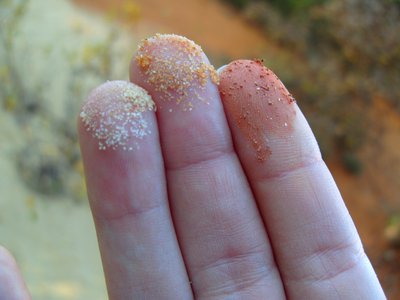
Grains de sables ocreux - ©Eric Garnier - PNR Luberon Patrimony and historyOcher and operation
Below is the old mining area Barriès (private - guided tour only). From washing, then decanting in large basins, to drying, crushing, and baking, a large scale of natural pigment was made, with a variety of colors. Launched in the 18th century, the industrial process for making ochre pigment reaches its high point in the 1920s. Today, the Société des Ocres de France still operates a quarry in Gargas and produces 1200 tons of ochre per year.
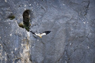
Vautour percnoptère - ©David Tatin  Fauna
FaunaProtected vultures
In the 80s, the cliffs just above Rustrel housed a famous couple of Egyptian vultures. Smaller than European vultures, this scavenger and detritivorous animal is also a long-haul flight expert! In 1998, thanks to tracking markers, school children were able to follow their migration to Sahelian Africa. The couple disappeared from our skies for a few years and their young descendants have not taken over. There are a hundred of couples in France.
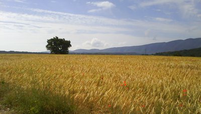
Champ messicole sur le plateau de Caseneuve - ©Eric Garnier - PNR Luberon FloraFlowering plants, the Luberon gem
Adonis, Cornflower, Love-in-a-mist... The Luberon is one of two regions of France richest in annual garden flowering plants, called "Harvest companions". Unfortunately, highly threatened in France, these plants depend completely on traditional farming for survival, as it is still done here by farmers that use little or no herbicides on their fields. The work of these farmers is essential for the preservation of a rich and fertile soil in the Luberon.
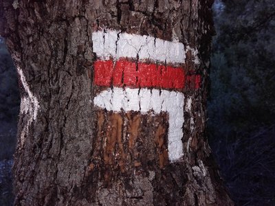
Balise GR, sur les traces de Morenas - ©Eric Garnier - PNR Luberon Patrimony and historyMorenas, the avant-gardist
In the Provençal Colorado, Francis Morenas was the first one to mark hiking routes in 1953. True pioneer of the southern GR, often called a "fada" (an informal term used to say someone is a bit nuts, crazy) by the locals, with his billhook and his pickaxe, he prepared over 1500km of trails between Ventoux, Monts-de-Vaucluse and Luberon. Fascinated, he loved above all sharing his pleasure for the outdoors with others. Until his last breath, he continued to maintain his footsteps, which have now more or less disappeared.
Petit Rhinolophe - ©DR-Le-Dauphiné FaunaForests as guides...
The maintenance and development of woodlands and deciduous hedges is very important for bats. These areas serve as their hunting grounds and above all, as reference points. Some species are able to make a 5km detour to reach two places a kilometre apart only because they prefer to follow a straight line of hedges rather than to cross an open space.
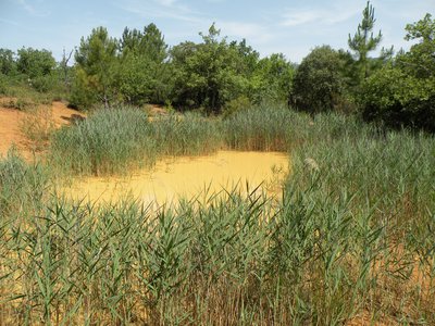
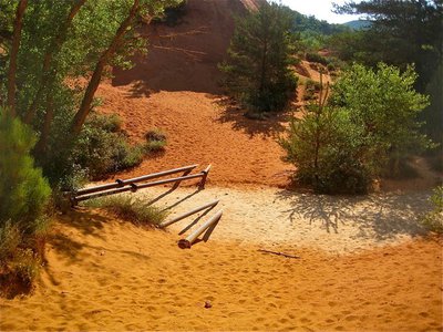
La mare au printemps - ©David Tatin FaunaTrou des Américains pond
This wetland is rooted in the ochre activity of the site and served to store the water used for washing the ochre. This is one of the best preserved ponds of the Luberon Regional Nature Park which is a part of the known breeding sites of Western Spadefoot (or Spanish Spadefoot Toad). This rare and vulnerable species in France is considered near threatened globally. With "spades" in its hind feet, it hides in the sand until it rains!
Front de taille ocrier érodé - ©Eric Garnier - PNR Luberon FloraLa Bruyère hill
Like a siliceous island in the middle of a limestone ocean, the hill of La Bruyère (listed and labelled as an environmentally sensitive area) contains a flock of siliceous (silica-loving), acid-loving (likes acid soils) and psammophile (preferring sand) plants. You can come across many species of amphibians (like the Western Spadefoot), birds (such as the European Bee-eater) and bats (like the Greater or the Lesser Horseshoe Bat, the Common Bent-wing Bat).
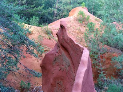
Front d'éboulement - ©Eric Garnier - PNR Luberon Patrimony and historyLandslide danger!
As holed as cheese, the hill of La Bruyère is pierced with ancient galleries dug by hand. It was an important place for the extraction of ochre. Then, a number of them were transformed into mushroom growing areas. Today, there is no longer human activity. Some have become refuges for large colonies of bats. It is strictly forbidden to enter the galleries (private property), due to frequent landslides and to avoid dramatic disturbance of bats.
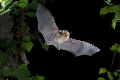
Minioptère de Schreibers - ©DR FaunaThe Common Bent-wing Bat
The hill of La Bruyère hosts the largest transit site of Common Bent-wing Bats in the Luberon. This bat feeds on moths. Very sociable, it settles in clusters in ochre galleries. Its protection is primarily based on tranquillity, especially since the closing of holes with grids is harmful to the Common Bent-wing Bat, because its flight, hard to manoeuvre, does not allow it to move easily between the bars.
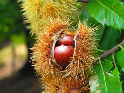
Chataîgne dans sa bogue - ©DR FloraChestnut from acid soils
A small island in the middle of the limestone mountains of Luberon and the Monts-de-Vaucluse, the ochres are home to species of trees that do not grow in limestone. Thus, the chestnut enjoys this ground as it enjoys the sandy soil in the Var department further to the south.
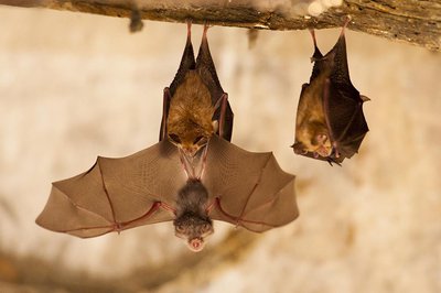
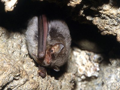
Jeune petit rhinolophe - ©DR-Tanguy Stoeckle FaunaLesser Horseshoe Bat
A true little fur ball, this bat weighs only 2 to 5g. The species has a distinctive horseshoe-shaped nose. When roosting and hibernating, the Lesser Horseshoe Bats hang free and wrap their wings completely around their bodies, resembling a pear hanging free. In winter, it occupies ochre galleries. In summer, the females use the huts as maternity wards. Be careful not to disturb them! It is strictly forbidden to enter the galleries and huts (private property), due to frequent landslides and to avoid dramatic disturbance of bats.
Cabanon refuge chauve-souris - ©Eric Garnier - PNR Luberon FaunaA hut as a maternity ward
In the fields nearby, huts were built to provide shelter and storage. Today abandoned or restored, they are privileged and coveted places by female bats. A true maternity ward, these huts, heated by the sun, are suitable places for birthing and nursing the young.It is strictly forbidden to enter the huts (private property) to avoid dramatic disturbance of bats.
Plateau des Claparèdes, sur la GTV - ©Julien Abellan Patrimony and historyThe "Grande Traversée VTT" (mountain bike route) of Vaucluse
The Grande Traversée VTT of Vaucluse is 388km of fun and a personalised course! Starting with the challenging trails of Mont Ventoux, passing through the limestone ridges of the Dentelles de Montmirail mountain range, you will go through a remarkable natural area to reach the Gorges de la Nesque. Then, the race continues through the Luberon Regional Nature Park, where the dry stone structure heritage, the impressive cliffs and trails in the ochre will delight mountain bikers.
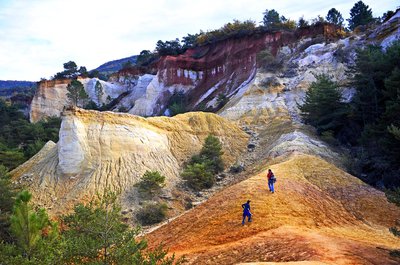
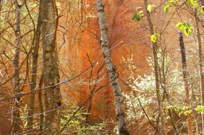
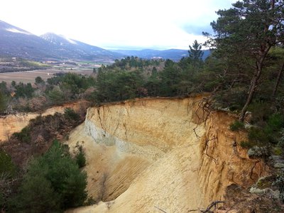
Front de taille ocrier - ©Anne-Camille Vinson - PNR Luberon  Panorama
Colourful channels
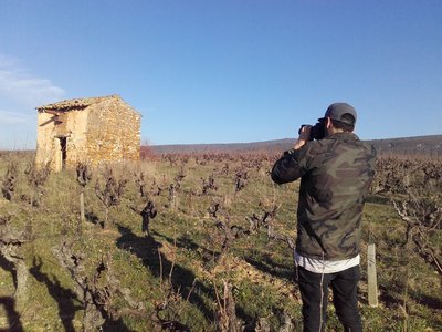
This route, away from the Calavon, flowing between the massifs of the Monts de Vaucluse to the north and Luberon to south, bypasses the Ocres de Rustrel massif. These colourful cliffs clearly stand out of the wooded hills of this agricultural valley dominated by vineyards. Resulting from a particular geological formation and past human exploitation, this richly coloured excavated face is threatened by forest takeover.
Description
Exit Rustrel following the GR® and the GTV®. Cross the D22 and at the crossroads ''Cornet'', turn left. Go along the former car park of Colorado and reach the start of the DFCI track.
1 - Turn right, cross the ford on La Doua, then rise by the track. Pass two winding paths and at the crossroads ''Barriès'', turn left on a rocky path. Cross a sandy narrow gully and continue straight. Come out on the paved track and reach further onto a road. Turn right and climb to the pass.
2 - Leave the GR® behind and the GTV® to the left and continue straight. Glide and go straight to the crossroads"Pradenques'' and"Ubac de Pradenques'', then climb to the plateau. Follow to the right the 1st track (RP). At the 2nd crossing, turn right on the path. After a ledge, turn right and then immediately left to reach the edge of the plateau. Then, go along a big field and reach the"Croix de Christol''.
3 - Take a left and 50m further, turn right. Continue straight on the trail, and then down the slope to the road. Follow it to the right, cross the hamlet of Haute-Blace and continue for 1.5km. At the exit of left turn, turn right and go down to La Doua. At the bottom, turn right, cross the D22 with caution andturn left on the track at the entrance of Jean-Jean. At the next crossroads continue straight. Above, follow the small road to the small mountain pass of Trécassats (marking"The Ochres by bike").
4 - Take on the right, the coloured trail parallel to the path (GTV® marking), then climb right to the top of La Bruyère (interpretation panels). At the crossroads ''Trou des Américains'', follow to the right the GR® and thus through all the ochre massif. Coming out on the road ''La Glaurivette'', follow the D214 to the right and 550m further turn left, cross the hamlet of Viaux, cross the D179 and climb a gravel path.
5 - Go down the road for 400m and take the first road to the left. Go up gently, turn right on the ledge and then embark on a beautiful rocky single track that falls between oaks and scrubs. Lower down, after a last turn, follow the opposite path along the foot of the massive and return quietly to Rustrel.
- Departure : Rustrel village
- Arrival : Rustrel village
- Towns crossed : Rustrel, Gignac, Caseneuve, Apt, Saignon, and Villars
Forecast
Altimetric profile
Recommandations
Respect strictly the mountain bike riding ban in the of Colorado Rustrel (classified site). Beyond this, remain absolutely on the marked trails and paths.
Be careful when crossing the ledge between points
Drink enough water; no water spring on the way!
Information desks

House of the Luberon Regional Nature Park
60, place Jean Jaurès, 84400 Apt
In the heart the old town centre of Apt, the House of the Luberon Regional Nature Park welcomes you in a town house of the 18th century. The permanent exhibition of the geology museum has a rich collection of fossils evidencing the geological history of the Luberon.
On sale at the shop: books, maps, guidebooks, games, posters...
Open Monday to Friday from 8:30 am to 12:00 pm and from 1:30 pm to 6 pm (and on Saturday, depending on the program). Free admission.

OTI Pays d’Apt Luberon
788 avenue Victor Hugo, 84400 Apt
Du 1er avril au 30 septembre
Ouvert du lundi au samedi de 9h30 à 12h30 et de 14h à 18h.
Juillet et août : Ouvert dimanche et jours fériés de 9h30 à 12h30
Du 1er octobre au 31 mars
Ouvert du lundi au mardi et du jeudi au samedi de 9h30 à 12h30 et de 14h à 18h.
Fermé le mercredi, dimanche et jours fériés.
Transport
Small car parks on each side of the road at the entrance of the village.
Access and parking
At 10km northwest of Apt by the D22 and D3011.
Parking :
Source

Report a problem or an error
If you have found an error on this page or if you have noticed any problems during your hike, please report them to us here: