The Routo of Baume Brignolle
On the heights of St-Rémy-de-Provence, between mountain ridges and valleys, the hike follows steep passages in the northern mountain chainsof the Alpilles and open plateaus to the South, for complete immersion in the landscapes of the Alpilles. This long walk on the path of Baume Brignolle, is an invitation to discover the nature and heritage of the area, through the actions of the park to protect this biodiversity and the land which it owns.
9 points of interest
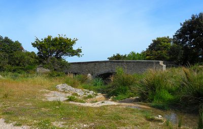
Le pont vu du gaudre de Romanin - ©Jason Gaydier - PNR Alpilles  Patrimony and history
Pont dit Romain
The bridge called Pont dit Romain does not date from Antiquity but from the Middle Ages. Its name still remains a mystery today. It was built on the chemin des Poissonniers, which was already used during Antiquity, to replace the crossing point that passes through the gaudre of Romanin (a gaudre is a temporary water body). This ancient route started from the chapel Notre-Dame de Piargues (or Notre-Dame-de-Romanin) and joined Mouriès crossing the Vallongue.

Les ruines du château au pied du piémont - ©Jason Gaydier - PNR Alpilles Patrimony and historyThe castle of Romanin
On your right is the castle of Romanin. At the foot of the ridges, this fortified place now in ruins was built to protect the north side of the Alpilles. It was controlled by the Lords who were themselves under the governance of the Counts of Provence. Its construction date has not yet been researched, but the most ancient texts had already mentioned it in the 12th century.

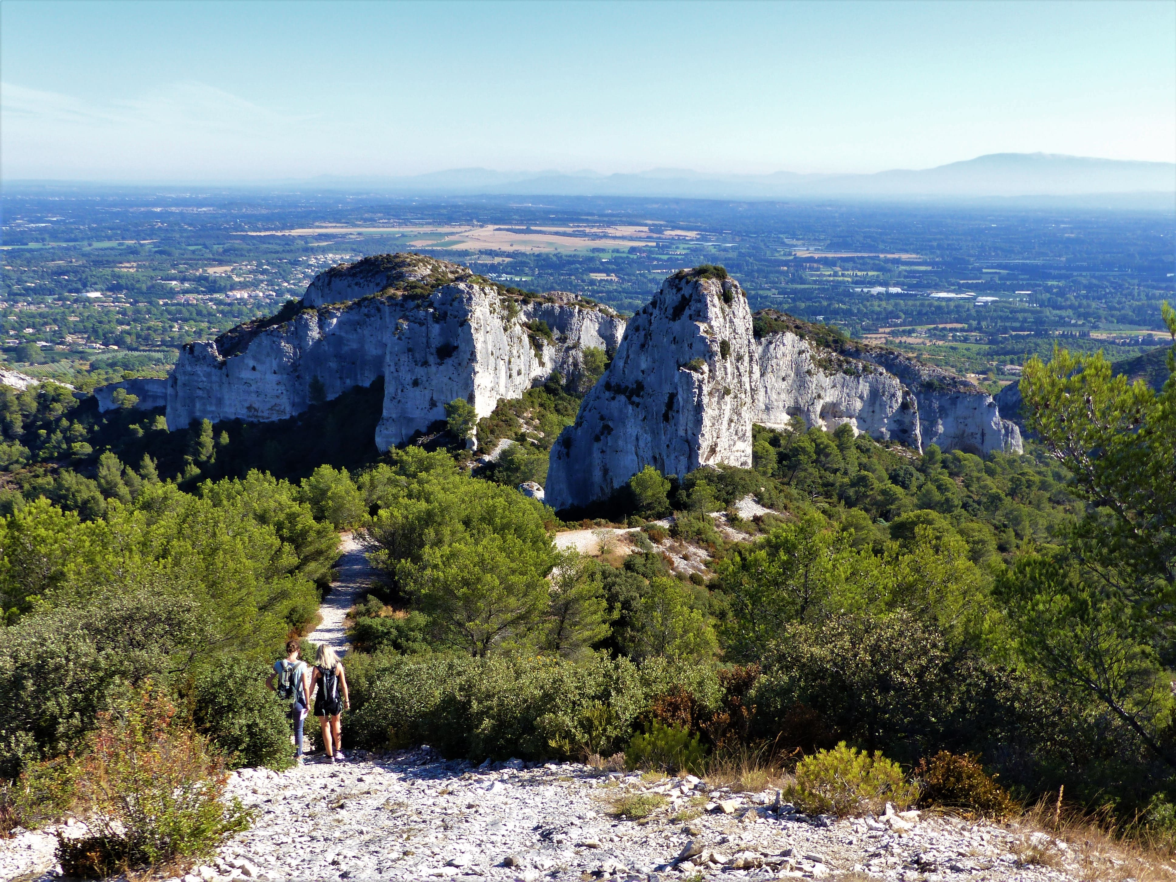
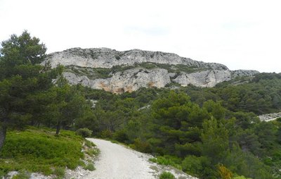
Le piémont sud vu du chemin de Baume Brignolle - ©Jason Gaydier - PNR Alpilles  Geology
The Alpilles ridges
The Alpilles have been constantly evolving for over the past 135 million years, to become the one you're standing on. These limestone ridges, bordered by the GR6, date back to the Cretaceous and appeared there about 70 million years BC. They dominate the Petite Crau. From here you can see the Montagnette massif to the northeast, and further away, Mont Ventoux, which rises to an altitude of 1912m. In the south, you have a wide view of the Alpilles.
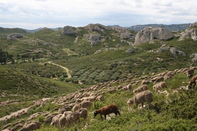
Troupeau de Mérinos dans les Alpilles - Patrick Fabre_Maison de la Transhumance  Elevage et pastoralisme
Mérinos d'Arles sheep breed
The Mérinos d'Arles, cross-breed between Mérinos d'Espagne and the breed of Arles, is the emblem of the great transhumance. Its herd-like instinct and its ability to adapt to different environments have favoured its expansion throughout the region. Known for the quality of its meat and its wool, it helps maintain the natural sites and landscapes from the delta of the Camargue, the Crau steppe or the Alpilles massifs until the peaks and alpine lakes.

Entrée de la zone de protection - ©Jason Gaydier - PNR Alpilles  Flora
FloraProtecting the biodiversity
A Prefectural Decree for biotope protection is a defined geographical area that preserves the ideal conditions for the development of certain plant and animal species. These biotopes are natural areas which are environments with a very fragile balance. On the Plateau de la Caume, this decree primarily concerns the Bonelli's eagle. Other protection areas, such as Nature Reserves exist to protect this rich biodiversity.
Point de vue sur le cirque - ©Jason Gaydier - PNR Alpilles  Panorama
The Valrugues valley
This is the perfect place to observe raptors and other birds (Bonelli's eagle, Egyptian vulture, Alpine swift), which have made it hunting ground. You can also see the Rocher des Deux Trous, to the west of the valley. This geomorphological phenomenon is the result of wind erosion, which dug into the limestone as to form two holes, hence the name. To the east, you will notice the steepness of the cliffs, true natural walls.
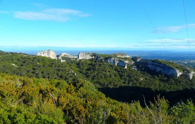
Le plateau vu du chemin de Baume Brignolle - ©Jason Gaydier - PNR Alpilles PanoramaPlateau de la Caume
Plateau de la Caume is "must see" site of the Alpilles. WIth a peak at 378m above sea level, this limestone feature is a crossing point of the GR6, the perfect route to discover the ridges of the Alpilles. This area hosts a rich ornithological biodiversity with the Bonelli's eagle, the Egyptian vulture, but also the Western jackdaw. Combined with human activity (passing of hikers, telecommunication towers), the site illustrates the Alpilles, which combines nature and civilization.
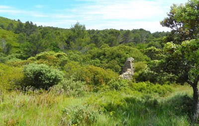
Les ruines du Jas - ©Jason Gaydier - PNR Alpilles Elevage et pastoralismeJas du Pézou
Here are the ruins of the Jas du Pézou. The word "Jas" comes from the Provençal language and means "house." This is a large building in dry stone, which allowed the housing of flocks and herds. It was rather built away from farms or homes. This allowed to shelter the animals when they were brought to graze on the way to Baume Brignolle, and must have had a link with the Pierredon castle located a little further south.

Entrée du domaine - ©Jason Gaydier - PNR Alpilles  Produits du terroir
The Vallongue farmhouse
Located at the southeast end of the Alpilles ridges, the Vallongue domain has 38 hectares on which is produced wines and olive oils. These vineyards were the first to turn to organic farming, as of 1985! Reds, whites and rosés benefitted from Les Baux de Provence Appelation d'Origine Protégée (AOP) label and Alpilles of Vallongue Indicateur Géographique Protégé (IGP) label, proof a real know-how.
Description
From the car park of the bridge said to be Roman, cross the ford and start hiking through the wooded path. Continue until you leave the shaded area to reach the fruit cultivations.
1 – Head towards the Chateau Romanin on the left after crossing the vineyards and tree crops to either side of the path. Before reaching to the castle, follow the trail marked in red and white (GR6®) which plunges to the left and climb to the Col de la Vallongue. Then turn right and continue along the narrow stony path, first at the foot of the ridges and then all along them.
2 – Enter the zone for biotope protection, covered by prefectoral decree. Turn left at the crossroads after taking a few steps in the middle of the surrounding vegetation, and follow the trail to leave the pylon on the right. Continue straight. Across the telecommunication antenna, follow the road that continues downwards to leave the plateau of Caume.
3 – Below the plateau, continue straight at the first intersection before turning left at the next intersection to take the Chemin de Baume Brignolle. After 800m, at the crossroads where 6 paths meet, follow the second path to the left, it is the DFCI AL 115 track. Continue on Chemin de Baume Brignolle until you reach on the D24.
4 – Continue straight along the main road. Preferably, take the small path which is on the left. Continue until the crossroads between the D24 and the D25.
5 – At the intersection at the bridge, follow the D24 towards Eygalières until the bridge saidRoman bridge, end point of the hike.
- Departure : The bridge said to be Roman, in Eygalières
- Arrival : The bridge said to be Roman, in Eygalières
- Towns crossed : Saint-Rémy-de-Provence and Eygalières
Forecast
Altimetric profile
Recommandations
Beginners should refrain. This hike is long and follows steep passages.
Unmarked section of the Chemin de Baume Brignolle (between reference points 3 and 4).
Bivouacs and dogs (even on leash) are prohibited in the Prefectural decree area of the biotope protection.
Information desks
House of the Alpilles Regional Nature Park
2, boulevard Marceau, 13210 Saint-Rémy-de-Provence
Located in the heart of the city centre of Saint-Rémy-de-Provence, the House of the Alpilles Nature Park welcomes you to its completely renovated premises. This new vibrant place is multifunctional: it accommodates the Park's engineering team but also has a public reception space and showrooms. A true resource centre of the Park's heritage, it aims to support and promote locals, visitors and tourists on all 16 municipalities of the Park.
Open Monday to Friday, from 9 am at 12:30 pm and from 1:30 pm to 5 pm.
Free admission.

OTI Alpilles-en-Provence
Place Jean Jaurès, 13210 Saint-Rémy-de-Provence
Access and parking
The starting point is on the D24, between Eygalières and the junction with the D25, at the car park of the bridge said to be Roman.
Parking :
Report a problem or an error
If you have found an error on this page or if you have noticed any problems during your hike, please report them to us here: