Traces Vaudoises
"One can approach the tragedy of the Vaudois in Luberon by plunging into the abundant literature produced on this subject. But nothing is better than going to the discovery of Waldensian traces in the countryside, smelling the air of this Vaudois country, feeling its soul, never extinguished, going to the old haunted village of Merindol destroyed by swordmore than 400 years ago". Serge BEC - journalist, Provencal poet and former deputy director of the Luberon Park.
24 points of interest

Clocher au « bulbe Sarrazin » unique dans la région - Fabrice Teurquety - OTI Coeur Provence  Patrimony and history
The St. Anne church
Ranked as a historical monument in 1992, the building located right next to the town hall originates from a small wooden chapel built in 1667. Voluntarily destroyed by an inhabitant of Mérindol, he was tried and forced to replace a brick building which we do not know the date of construction. Became too small with the forced conversion of Protestants in 1685, it was demolished to make way for the present church between 1748 and 1754.

La Muse - Fabrice Teurquety - OTI Coeur Provence Patrimony and historyThe muse
Headquarters of the Association of Vaud and Historical Studies of the Luberon, the Muse is also the Museum (private) Vaudois in the region that brings together all the documentation concerning the history of this religious minority in the world, especially in the Luberon. Guided tours for groups and individuals, by appointment (Tel. 04 90 72 91 64).

DR Patrimony and historyThe Mérindol Vaudois
Created in 1170 by a wealthy citizen of Lyon Valdes (or Vaudes), the Waldensianism is a movement that advocates a simple lifestyle, close to that of the first disciples of Jesus of Nazareth. Having separated from the ostentatious luxury of the Catholic Church, these Vaudois, expelled from Lyon in 1184, settled in the south of France, Provence, Languedoc, Dauphine, and Italy.
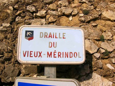
DR Patrimony and historyDraille Old Mérindol
A draille is a passage, a trail or path followed from time immemorial by transhumant sheep. Here Mérindol Draille once used for cattle to reach Craux upstream of the village. As for the name Mérindol, it comes from « mar » and « rondolo » or « sea swallow » in Provençal.

Vue sur la plaine de La Durance et le village de Mérindol - Stephane Legal - PNR Luberon Patrimony and historyWaldensian families of Mérindol
In 1504, 11 Waldensian families settled in Mérindol with the agreement of the Bishop of Marseilles. In 1532, the Vaudois, dissenting Catholics will embrace the Reformed Church at the Synod of Chanforan (Piedmont). After years of persecution, Mérindol edict of the Parliament of Aix in 1540 led to the destruction of the village of Mérindol in 1545. The Vaudois memorial, located upstream on the ruins of the original village also offers a panoramic view.

Massacre des Vaudois - DR Patrimony and historyPersecution of heretics
It was the arrival of John Apt Roma Dominican inquisitor in the 1530s, which marked the intensification of persecutions against the Vaudois. Hunted down, imprisoned, burned to death or sent to the galleys, they frequently refuge on Mérindol heights in the wild valleys and the nearby caves. The violent struggle against heretics continues, until the intervention of the king, alerted by the turn of events and enrichment of the inquisitor by looting.

Ruines du mémorial et Roque Malière au fond - Eric Garnier - PNR Luberon Patrimony and historyThe massacre of 1545
In 1540, a judge from Apt arrested and burned a Protestant miller from Mérindol. He then used the mill to his advantage. The vaudois from Mérindol revolt. This resulted in convictions and following the edict of Mérindol on November 18, 1540, 19 people were condemned to the stake. After several delays and graces granted by the king for them to recant their heresy, grace was removed on January 1, 1545. The village was burned April 18, 1545, the inhabitants were captured and massacred in Vaud.

Vue sur la Durance depuis le mémorial - Eric Garnier - PNR Luberon Patrimony and historyForgive and do not forget!
In spring 1545, in the Luberon, over 3000 people were massacred and 24 devastated villages, including that of Merindol, burned and passed to the sword. This is between the old walls parts of the old castrum, the Vaudois memorial was inaugurated in 1978 through the initiative of three Vaud associations of Germany, Italy and France. He recalls this: "To the Protestants of Provence, many died from being Vaudois, a branch of the church created in 1170 by Valdes and attached to the Reformed Church in 1532".

Vue sur La Durance et le pont de Senas - Stephane Legal - PNR Luberon Patrimony and historyThe ferry on la Durance
The view from the heights of Mérindol, hanging on the southern slope of the small Luberon, extends to the alluvial plain of the Durance. Below, the meanders of La Durance. A ferry that enabled to cross the river was established in 1240. In the 15th century, it disappeared in favor of that of Senas.

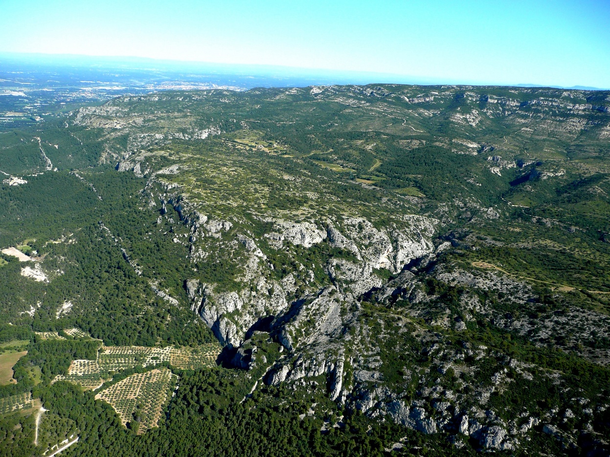
Ruine de la Crau des Plaines - Eric Garnier - PNR Luberon  Flora
FloraGarrigue and agricultural remains
The garrigues are plant formations that come from the degradation of the Mediterranean forest, mostly by fire or overgrazing. The specific flora of the garrigue (rosemary, kermes oaks, grey-leaved cistus ...) can withstand extreme aridity during the summer season and has a great ecological richness.? The ruins just north of the road (probably used to be a magnificent building) reflect the antiquity of pastoral and agricultural activities on the plateau.

Les sapins de la Font de l'Orme - DR FloraArboretum of the Font de l'Orme
The Arboretum of Font de L'Orme dates from 1864. A small pathway presents some 50 species of trees including 4 species of Mediterranean pines. Managed and maintained by the Luberon National Forest Office, it also houses a log cabin, still inhabited by a forest officer. Small signs will help you recognize these different species. A privileged place to appreciate the ecological richness of the Mediterranean forest.
Puits de la Font de l'Orme - Eric Garnier - PNR Luberon  Water and rivers
precious water wells
You could see the fountain in the center of Mérindol and several wells. You will come across some of them throughout your ride, in more or less good condition. Nearly every abandoned today, they reflect the efforts implemented once to bring water closer to the villages, but also livestock. The aridity of the Luberon is known and these wells were essential to all pastoral activity.

Crau de St-Phalez, puis craux de Camargue et massif des Alpilles - Stephane Legal - PNR Luberon Patrimony and historyWaldensian peasants
Many Vaudois workers from Briançon and Piedmont, recultivated abandoned land around isolated houses. The farm nearby St. Phales, counted up to 250 Huguenots! Until 1530, they fit discreetly in social and ecclesial life before François the 1st, aware of the magnitude of the reformed wave, ordered the bishops and parliaments to pursue the "faithless" accused "of Waldensian and Lutheran heresy".
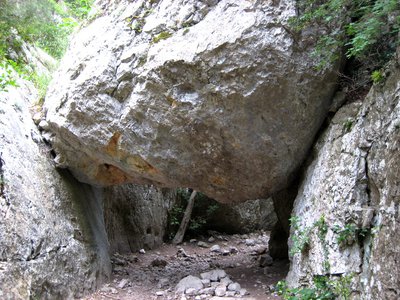
Fond des gorges Régalon - Eberhard Scherzler  Geology
The Régalon canyon
Below, the Régalon notches the south side of the Petit Luberon with a sumptuous and surprising gash! How did this little stream create this incision in hard limestones? The cause of this is in the closure of the Strait of Gibraltar, 6 million years ago. The Mediterranean Sea is lowered to 1,500m. The entire river network will sink and dig canyons. This is the case for the Rhone river which used to flow 900m lower down from the Durance and the small river of Régalon.

Vautour percnoptère - ©Alexis Maury Dalmazane  Fauna
FaunaVulture protected vautour
The Egyptian Vulture is the smallest of European vultures. Scavenger and scavenger, its survival depends on the presence of sheep and goats which he operates carcasses. Its diet is varied, however, including all type of small dead animals (including fish) as well as small live prey (large insects, lizards, small birds). This is unfortunately highly migratory globally threatened with extinction, mainly because treatments for livestock.

Couple d'aigles de Bonelli - Max Gallardo - PNR Luberon FaunaThe Bonelli's eagle, rare and endangered
This Mediterranean raptor is one of the most endangered species. In France, there are about 30 pairs among which 1 is located in the Luberon in contrast to about 10 in the 50s. This disappearance is due to electrocution, theft of their eggs (by collectors), gun shootings, increased human disturbance of its nesting sites, the decrease of its main prey (wild rabbit, red-legged partridge) and the closing the open environments where they hunt. The pair, united for life, will nest on the rock wall of limestone mountains.
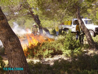
Brûlage dirigé - ©Lionel Kmiec - ONF Luberon FloraBush burning
Bush burning is the act of burning weeds, and other plants in a defined area, safe for neighboring areas. This technique helps to fight against fires by reducing the mass of fuel but also promotes the maintenance of the area, which keeps the pastoral activity on dry lawns. Bush burning is fully managed by the National Forestry Office.

Ferme des Mayorques - ©Sophie Bourlon - PNR Luberon Patrimony and historyThe Mayorques farm
This farm, occupied until the 1950s, now serves as a sheep pen and a welcoming and study place for the public. It was restored by the Luberon Regional Nature Park. An apricot orchard also preserves the old varieties which are endangered. This orchard manages to survive, despite the difficult terrain on which it grows but also the repeated droughts.

La crau et la ferme des Mayorques - ©Eric Garnier - PNR Luberon  Elevage et pastoralisme
Les Craux: between Man and Nature
Grazing in the Craux dates back to the dawn of time! Many herds, mainly sheeps, in extensive grazing, helped maintain a habitat for a variety of plant and animal species. Rosemary, Dwarf Iris from the garrigues but also many species, from insects to raptors, coexist in these areas.

Vautours percnoptère sur une placette de nourissage - ©Julien Baudat-Franceschi - PNR Luberon FaunaThe park and the Egyptian vulture
Globally threatened, the conservation of the Egyptian vulture involves working on the transcontinental scale. In France, strictly protected, it is the subject of a National Action Plan. Since its creation, the Luberon Park has been running a conservation program based on food support (recycling of slaughter waste), monitoring of nesting, and management of human disturbances. There are a few hundred couples in France (80 in the Pyrenees and 20 in the south-east).

Gorges de Régalon - Eberhard Scherzler FaunaGorges of Regalon
Scree, caves and rocky slopes create habitats of community interest, home to many animal and plant species. This ornithological landmark, whatever the season, sees nesting birds such as the Owl Grand Duke, the Blue Monticole (Blue Merle) or the White-bellied Martinet.
Sensitive area! Evidenced by a large number of legislations: Natura 2000 Birds Directive, Grand Raptors Biotope Protection Order, Geological Nature Reserve, State Biological Reserve, etc.

Envol d'un Vautour percnoptère - ©David Tatin FaunaPrivileged place for Egyptian vulture
With its well exposed rock walls, its breeding tradition, and the proximity of the Durance, the Petit Luberon massif hosts the largest number of breeding pairs in the south-east of France. 4 to 8 pairs feed on large areas, flying over garrigues, ridges, agricultural plains and wetlands. In the Luberon, they are threatened by the huge number of tourists, excessive aviation at low altitude, the scarcity of farmed carcasses and the closure of habitats.
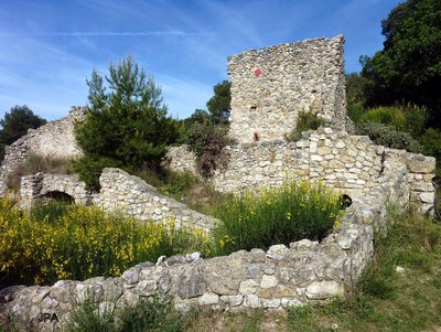
Ruines de la ferme des Cachots - DR Patrimony and historyThe Cachots
This old Vaudoise farmhouse used to be a prison. Many Vaudois from Mérindol have been imprisoned in this old farm, called since "the Cachots". In 1545, it was here that they waited to be burnt at the stake or for the lucky ones, to be sent via Marseilles to the galleys of the kingdom of France to fight the English.

Centaurée des collines - Eberhard Scherzler FloraCornflower’s cousin
If you are walking around between June and September, you may have seen this yellow flower, sometimes orange, in the middle of the crops, in the wastelands or by the wayside. The Centaurea of the hills (Centaurea collina L.) can be thought of as a thistle but its leaves are not thorny! A perennial Provencal plant, often found in Provence-Alpes-Côte d'Azur.
Description
From the Place Maurice Blampignon (party room), go left on the rue des Ecoles (tourist office), turn left on rue de la Mairie then rue du Vieux Four. Continue in front of the "Muse", go left and at the post, turn right. Find the old Mérindol (GR®). Continue on the Chemin de l'Apied.
1- Turn left, advance 60m, and turn right. Weaving through the ruins of the old village and reaching the Vaudoismemorial at the top. Go back up to point 1 and go up the coated road (GR®) to the left. Continue on the stone path. Continue straight ahead at the next crossroad and after 150m turn left on the trail (GR®). Take a path and follow it to the right. Turn left at the next crossroad and then get off.
2- At the "Sadaillan" crossroad, follow the trail on the left, go past the next crossroad and 50m down, turn right on a path. Pass two pins and reach a trail (GR®). Follow it to the left. Continue left and right, then turn left onto the trail. Join the arboretum of the Font de l'Orme. At the exit of the wood, join the trail at the corner of the parking lot.
3- Follow the trail of Saint-Phalez to the right and 150m further on, turn right. 270m higher, follow the trail on the left (GR®). Switch and turn left. Start on a new trail. Turn right, go past a cistern and continue 250m after the pin.
4- Switch left onto the trail. Continue right at the bottom of the valley and reach the top of the gorges of Regalon (pole). Turn right and go up. At the trail, go left. At the top of the valley of La Galère, leave on the right the GR®, pass the pin and reach a cistern then the wide crossroad of "Montagnas" (PR).
5 - Turn left and continue straight ahead. Climb the path that crosses a bump directly, find the trail and reach the old farm of the Mayorques (PR). Continue south (sheep pen), cross the crack. Cross the Ser trail through the rocky path.
6 - At the bottom, take the trail on the left. Continue left and reach the Régalon parking lot (PR). In front of the large oak, turn left and climb to the right the road to La Tulière. Pass the farm and continue along the trail. Find the ruins of the Cachots. Then turn to Petit and then Grand Champeau to the left (PR).
7- Turn left on the road to the Fond de l'Orme. Go along a large wall and then to the right climb a path under the pines (PR). Continue straight on the chemin du Bon Puits. Swing right on the way to the Muse and find the center of Mérindol.
- Departure : Place Maurice Blampignon, Mérindol
- Arrival : Mérindol
- Towns crossed : Mérindol and Cheval-Blanc
Forecast
Altimetric profile
Recommandations
Although the difficulty of this route is due primarily to its length (20km), it is necessary to pay attention to the ankles on the rocky passages, especially in the descent after the farm of the Mayorques.
Information desks

House of the Luberon Regional Nature Park
60, place Jean Jaurès, 84400 Apt
In the heart the old town centre of Apt, the House of the Luberon Regional Nature Park welcomes you in a town house of the 18th century. The permanent exhibition of the geology museum has a rich collection of fossils evidencing the geological history of the Luberon.
On sale at the shop: books, maps, guidebooks, games, posters...
Open Monday to Friday from 8:30 am to 12:00 pm and from 1:30 pm to 6 pm (and on Saturday, depending on the program). Free admission.

OTI Luberon Coeur de Provence
Place François Tourel, 84300 Cavaillon
Access and parking
At 18 km east of Cavaillon, through the D973.
Parking :
Access
- Emergency number :
- 114
More information
Source

Report a problem or an error
If you have found an error on this page or if you have noticed any problems during your hike, please report them to us here: