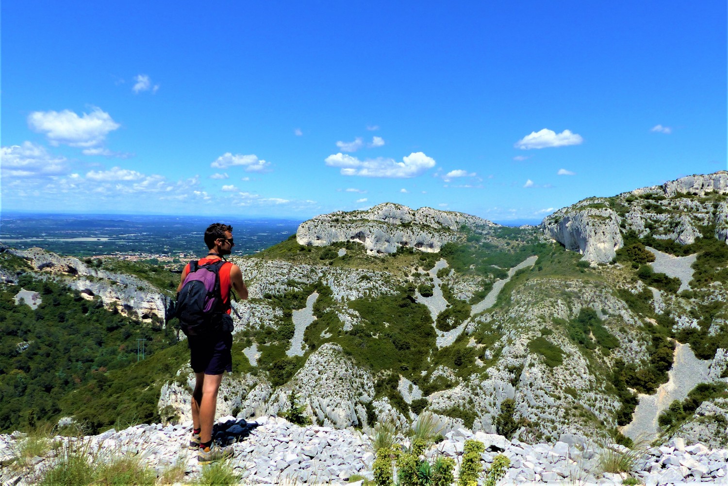
SAINT REMY DE PROVENCE - The Alpilles ridge
"A really nice hike, which offers us beautiful and varied views of the interior of the Alpilles, as well as the Avignon and Crau lowlands. I really liked some passages of a surprising beauty, like the vaults of green oaks, a gentle slope between rock faces and of course the ridge of the Alpilles. In any case, thrills guaranteed! "Clement Surun, Alpilles RNP.
14 points of interest
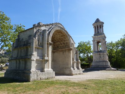
Les Antiques - ©Rémi Sérange - PNR Alpilles  Patrimony and history
The Antiques
These two monuments called "Les Antiques", marked the entrance to the town of Glanum: Mausoleum of the Jules and the Arc de Triomphe. The funerary Mausoleum dates from the years 30-20 BC.. It owes its fame to its unique structure in Roman architecture: Around 20 A.C, the arch lost the pediment which surmounted the vault. It is decorated with beautiful reliefs illustrating the conquest of Gaul by Caesar and fruits and foliage, symbols of abundance, carved under the vault.
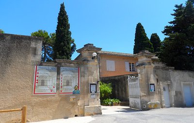
Entrée du cloître Saint-Paul - ©Jason Gaydier - PNR Alpilles Patrimony and historyThe Saint-Paul cloister
The Saint Paul cloister is a former monastery of the 11th-12th century. This building, built in true Roman style has lost its original purpose to be transformed into a cultural and tourist centre with Van Gogh as the main attraction and who was a patient here. Indeed, the Dutch artist stayed here between May 1889 and May 1890. You will find between these walls a museum about his stay, but also a reproduction of some 20 paintings of his. To be seen alone or with family!
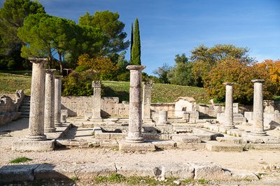
Site de Glanum_St Rémy de Provence - ©JCF-WeGo Productions Patrimony and historyThe site of Glanum
The archaeological site of Glanum is one of the "must see" sites of the town of Saint-Rémy-de-Provence, the result of over a century of excavations. This site, dating back to the 6th century BC, is a Celtic site which suffered from the Greek and Roman influences over the past centuries. After becoming a trading and religious centre in the Alpilles, it was destroyed in the 3rd century AD during the barbarian invasions. The survivors abandoned the area to build the foundations of Saint-Rémy-de-Provence and to settle there.
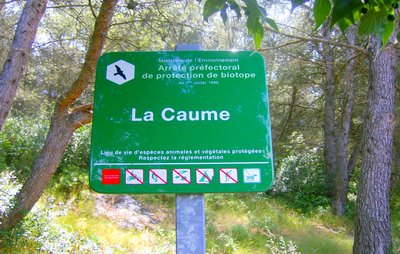
Entrée dans la zone de protection - ©Virginie Brunet Carbonero - PNR Alpilles  Flora
FloraProtecting the biodiversity
A Prefectural Decree for biotope protection is a defined geographical area that preserves the ideal conditions for the development of certain plant and animal species. These biotopes are natural areas which are environments with a very fragile balance. On the Plateau de la Caume, this decree primarily concerns the Bonelli's eagle. Other protection areas, such as Nature Reserves exist to protect this rich biodiversity.
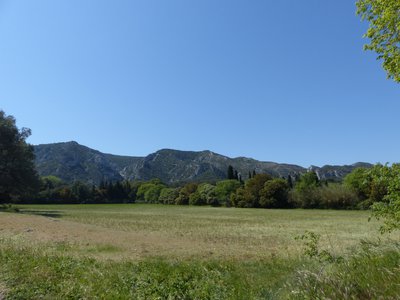
Le mont Gaussier - ©Jason Gaydier - PNR Alpilles  Panorama
Mont Gaussier
Mont Gaussier is one of the peaks of the Alpilles with an archaeological interest. This limestone mount rising to 306m above sea level, was indeed a living environment. The oldest traces date back to protohistory (period between prehistory and history). This occupation lasted until the Middle Ages. In fact, archaeological researches have found indications leading to what may have been foundations for walls or dwellings.
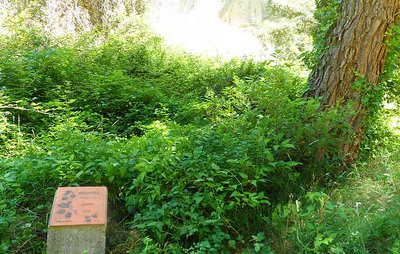
Sentier botanique le long du vallon - ©Jason Gaydier - PNR Alpilles FloraA trail to discover the flora
You will have the opportunity on the first part of the trail to come across small milestones. Each one has a small drawing of a branch, the shape of its leaves, and its name in French and Latin. They mark out a nature trail set up by the Association of hikers La Draille, along with the tourist office of Saint-Rémy-de-Provence. It allows visitors of all ages to recognize the surrounding flora.
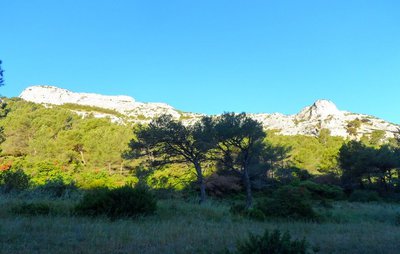
Le plateau vu du chemin de Baume Brignolle - ©Jason Gaydier - PNR Alpilles PanoramaPlateau de la Caume
Plateau de la Caume is "must see" site of the Alpilles. WIth a peak at 378m above sea level, this limestone feature is a crossing point of the GR6, the perfect route to discover the ridges of the Alpilles. This area hosts a rich ornithological biodiversity with the Bonelli's eagle, the Egyptian vulture, but also the Western jackdaw. Combined with human activity (passing of hikers, telecommunication towers), the site illustrates the Alpilles, which combines nature and civilization.
Point de vue sur le cirque - ©Jason Gaydier - PNR Alpilles PanoramaThe Valrugues valley
This is the perfect place to observe raptors and other birds (Bonelli's eagle, Egyptian vulture, Alpine swift), which have made it hunting ground. You can also see the Rocher des Deux Trous, to the west of the valley. This geomorphological phenomenon is the result of wind erosion, which dug into the limestone as to form two holes, hence the name. To the east, you will notice the steepness of the cliffs, true natural walls.

Entrée de la zone de protection - ©Jason Gaydier - PNR Alpilles FloraProtecting the biodiversity
A Prefectural Decree for biotope protection is a defined geographical area that preserves the ideal conditions for the development of certain plant and animal species. These biotopes are natural areas which are environments with a very fragile balance. On the Plateau de la Caume, this decree primarily concerns the Bonelli's eagle. Other protection areas, such as Nature Reserves exist to protect this rich biodiversity.
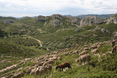
Troupeau de Mérinos dans les Alpilles - Patrick Fabre_Maison de la Transhumance  Elevage et pastoralisme
Mérinos d'Arles sheep breed
The Mérinos d'Arles, cross-breed between Mérinos d'Espagne and the breed of Arles, is the emblem of the great transhumance. Its herd-like instinct and its ability to adapt to different environments have favoured its expansion throughout the region. Known for the quality of its meat and its wool, it helps maintain the natural sites and landscapes from the delta of the Camargue, the Crau steppe or the Alpilles massifs until the peaks and alpine lakes.

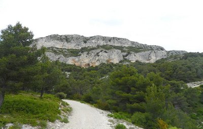
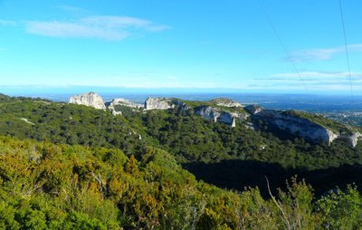
Le piémont sud vu du chemin de Baume Brignolle - ©Jason Gaydier - PNR Alpilles  Geology
The Alpilles ridges
The Alpilles have been constantly evolving for over the past 135 million years, to become the one you're standing on. These limestone ridges, bordered by the GR6, date back to the Cretaceous and appeared there about 70 million years BC. They dominate the Petite Crau. From here you can see the Montagnette massif to the northeast, and further away, Mont Ventoux, which rises to an altitude of 1912m. In the south, you have a wide view of the Alpilles.

Les ruines du château au pied du piémont - ©Jason Gaydier - PNR Alpilles Patrimony and historyThe castle of Romanin
On your right is the castle of Romanin. At the foot of the ridges, this fortified place now in ruins was built to protect the north side of the Alpilles. It was controlled by the Lords who were themselves under the governance of the Counts of Provence. Its construction date has not yet been researched, but the most ancient texts had already mentioned it in the 12th century.
Vue sur le massif des Alpilles - ©Rémi Sérange - PNR Alpilles PanoramaThe Eagle Footprint
The Eagle Footprint is a cliff located in the town of Saint-Rémy-de-Provence and it is part of the north facade of the Alpilles. It is part of the foothills of the plateau of La Caume and forms a genuine, impressive and steep natural border 392m high.

Panneau d'information de la Via Domitia - ©Rémi Sérange - PNR Alpilles Patrimony and historyVia Domitia
Via Domitia is the oldest road in France, built from 120 BC based on ancient Gallic routes. Beyond the Spanish border, this route is called Via Augusta. This interprovincial road was built and maintained at the expense of the Roman state. Via Domitia was a very busy route followed by armies, officials, merchants, travelers, pilgrims throughout the Empire, and still remained in the Middle Ages.
Description
The burial works of the High Voltage line of the Caume, Saint-Rémy-de-Provence will take place between 18/09/2017 and 22/12/2017, down from the telecommunication relay to the Plaines car park. Diversion routes will be set up except for the portion between Vallon de Valrugues and the plateau, on the route of Gr6, which will be completely closed for a few weeks. Consult the map of the works on the Park's website for more details.
From the Antiques car park, along the D5 towards Saint-Rémy-de-Provence, and turn right to join the Cloister of Saint Paul Mausole, at the end of the path lined with plane trees.
1- Facing the Cloister, follow the road on the right to bypass it. At the Relais Information Service panel of the Alpilles Regional Nature Park, take Chemin des Carrières on the right. Follow the marked path PR (in yellow), which crosses valley and forest.
2- At the crossroads with the small paved road, follow it to the left. Continue on the road to the telecommunication tower of the Caume plateau. At the tower, turn left towards GR®6. After the sign of "Biotope", follow the ridge line to the right by a series of rocky steps.
3- After 2 km, turn to the right following the GR®6 and join the foot of the peaks. Continue between rocky passages and undergrowth to the Vallongue pass and its rocky gorge. Go down to the left to a road near the airfield (some passages require the hands).
4- Take the path on the left. From this point the circuit will be double marked PR (yellow) and GR® (red / white) until arrival. Continue for 3 km, remaining attentive to the marking, until a junction of marked paths and a property lined with walls.
5- Turn left and walk 500 m. Take a track on the right and then a small asphalt road. At the hairpin bend, turn left onto the path lined with properties.
6- At the fork stay on the right, further pass a barrier then continue to a stone cottage. After the shed, turn left. Cut the path where the GR®6 passes, go up between two wooden barriers and continue to the right on the path that joins the starting point.
- Departure : Antiques car park, Saint-Rémy-de-Provence
- Arrival : Saint-Rémy-de-Provence
- Towns crossed : Saint-Rémy-de-Provence
Forecast
Altimetric profile
Recommandations
For your safety, and for the preservation of forest areas, access to natural areas is regulated from June to September. Inquire during the summer period on 08 11 20 13 13 (price of a local call) or on www.bouches-du-rhone.pref.gouv.fr Download the application for free MYPROVENCE ENVIE DE BALADE (available on Appstore and Android Market).
Information desks
House of the Alpilles Regional Nature Park
2, boulevard Marceau, 13210 Saint-Rémy-de-Provence
Located in the heart of the city centre of Saint-Rémy-de-Provence, the House of the Alpilles Nature Park welcomes you to its completely renovated premises. This new vibrant place is multifunctional: it accommodates the Park's engineering team but also has a public reception space and showrooms. A true resource centre of the Park's heritage, it aims to support and promote locals, visitors and tourists on all 16 municipalities of the Park.
Open Monday to Friday, from 9 am at 12:30 pm and from 1:30 pm to 5 pm.
Free admission.

OTI Alpilles-en-Provence
Place Jean Jaurès, 13210 Saint-Rémy-de-Provence
Transport
.Look for public transport times on the site www.lepilote.com in the town of Saint-Rémy-de-Provence
Access and parking
From Saint-Rémy-de-Provence, follow the D5 towards Maussane-les-Alpilles. The departure is on the right, 800m before the entrance of the Glanum site.
Parking :
Access
- Emergency number :
- 114
Report a problem or an error
If you have found an error on this page or if you have noticed any problems during your hike, please report them to us here: