
Trails of the Maquis de Gordes through La Sénancole
To convey the memory of what the Resistance in Gordes was like during World War II, the cantonal association "Cadets de la Résistance" has marked and enriched two "memory lanes" around Gordes with information boards. This first tour (A) goes along the west side of Gordes, passes through the famous "Village des Bories", then up the wild valley of La Sénancole until reaching the impressive Sénanque Abbey...
23 points of interest
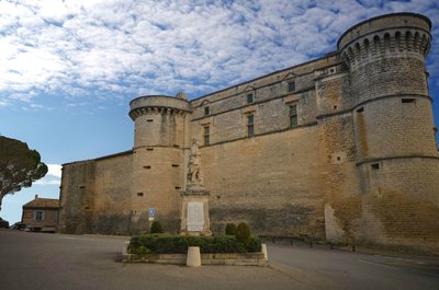
Château de Gordes - ©DR-Martine Passion Photos  Patrimony and history
The castle of Gordes
Since the revival of the first millennium, a castle is built on this rocky outcrop around which then develops the village. In the early 16th century, the Simiane the family built a new castle, which in its architecture is an illustration of the transition from the troubled times of the Middle Ages and the new lifestyle of the Renaissance. It has kept defensive elements:(Thick walls, towers with machicolation), but gradually opens up with its mullioned and transom windows.
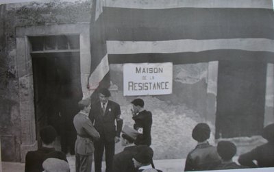
Inauguration de la Maison de la Résistance après-guerre à Gordes - ©DR-Anciens résistants de Gordes Patrimony and historyThe Resistance in Gordes
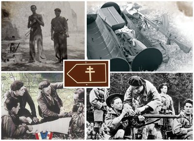
Prior to November 1942 and the invasion of the southern zone by the Germans and Italians, the Resistance had begun to organize itself particularly around several village traders. First, to help the many refugees running from the Nazis, and then, after the establishment of the Compulsory Work Service (Service du Travail Obligatoire - STO) to hide and train for combat and the clandestine life of many young Resistance fighters. In the spring of 1943, supported by the Secret Army (AS), the maquis of Gordes was born.
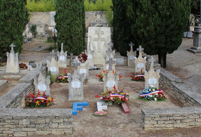
Carré des martyrs - ©DR-Anciens résistants de Gordes Patrimony and historySignificant losses
Disputes and arrests multiplied, the members of the Resistance, under the command of Paul Nouveau often changed camps or shelters, integrate the Ventoux maquis but can not avoid the deportation at the end of 1943 of their first leader, Emile Roure. Further losses are regrettable in 1944 upon the disastrous arrival of the 8th Company (military unit) of the Brandenburg division, which spread terror, hunting and infiltrating groups. 12 inhabitants of the Gordes will be killed in battle, or arrested, tortured and shot.
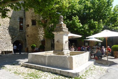
La fontaine du village - ©Jérémie Haye - PNR Luberon Patrimony and historyThe wash fountain of the town
In the shade of two plane trees, the building is a square surrounded by cobblestone decorations. In the centre stands the shaft, also square and 3.80m high. The wash fountain is supplied in water by four canons in wrought iron attached to a mascaron (ornament) carved instone. This wash fountain was erected in 1826 and allowed the residents from the upper side of the village to get a steady water source which was difficult given that the village is built on its rocky headland.
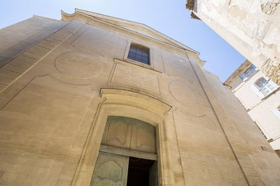
Eglise Saint-Firmin - ©DR-VMF Patrimony and historyThe Saint-Firmin church
Originally Romanesque, but highly deteriorated in the 16th century, the present church was rebuilt in the mid 18th century as evidenced by the neoclassical architectural style of its front façade with pilasters and pediments. Formerly dedicated to Notre-Dame, it has been dedicated since its reconstruction to Saint-Firmin, former Bishop of Uzès. Inside, the nave is flanked by eight side chapels.
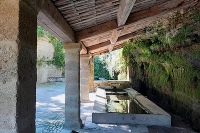
Lavoir de la fontaine basse - ©Eric Garnier - PNR Luberon Patrimony and historyThe low fountain
A few metres down the left, one of the oldest wash fountains of Gordes is hidden (it is mentioned in the middle of the 16th century). This wash fountain has the distinction of being built against the cliff. Water runs from the rock and three canons supply the wash fountain which overflows into the wash house provided with two basins for rinsing and washing. Uncommon today, wash fountains were once a focal point of the village life, a place of essential socialization.
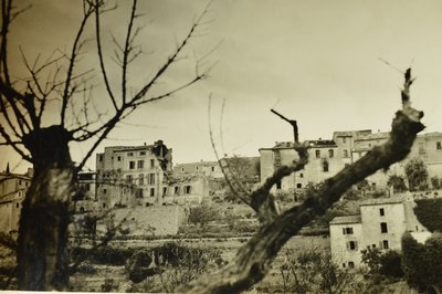
Gordes bombardé - ©DR-Anciens résistants de Gordes Patrimony and historyEnemy bombing
On August 22, 1944 the village of Gordes is bombarded from this headland. The Germans destroyed in a mortar attack many homes, others at the village entrance were blown up to prevent access. Most residents fled, those who stayed protected themselves however they could. In spite of everything, François Bruneau was ambushed and shot at his window by a German sniper.
Gordes - ©OTI Destination Luberon  Geology
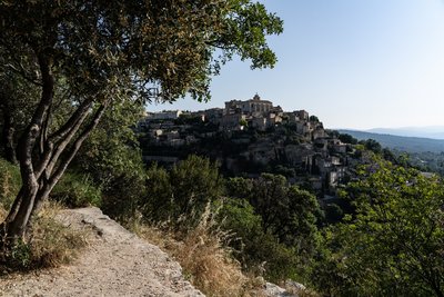
Gordes: Hilltop villages
Gordes is one of those typical Provençal villages, set in a defensive position on its limestone rock. In the Gallo-Roman times, Gordes was the main oppidum (public defence shelter) of the city of Cavaillon. With its cobblestone streets, small squares, Gordes is pleasant and offers a rich cultural life (exhibitions, festivals ...).
Les Grangiers, refuge de résistants - ©DR Patrimony and historyThe Grangiers, the resistant shelter
Here at the farm of Grangiers in spring of 1943, Roger and Bernadette Louis hosted the first resistants to the Compulsory Work Service (STO), who will join the different maquis of the area. In September 1943, the Germans were tipped-off and came to arrest Roger Louis. He managed to escape and joined the general staff of the Ventoux maquis. In the summer of1944, the soldiers of the 8th Company (military unit) of Brandenbourg return, pillaged the house, tortured and threaten to kill Bernadette. She then manages to escape with her five children.
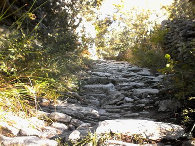
Calade du Coulet de la Sénancole - ©Eric Garnier - PNR Luberon Patrimony and historyWhat is a calade?
You must have heard the term "calade" while on a stroll. This term refers to a paved road or a cobblestone street. The word "calade" comes from the root "cal" meaning "stone" or "step" but also from "cala" in Provençal meaning "to go down". Some paths and many streets were paved so to facilitate the passing of men and animals, but also to limit erosion. First on slopes, public squares or fountain decorations, then they were paved for reasons of cleanliness.
Maquisards - ©DR-Anciens résistants de Gordes Patrimony and historyCoulet
By June 1943, it was here, near the Sénancole, where the first Resistance members, welcomed and trained by groups of the Secret Army, were initially grouped before having to find quickly other dens.
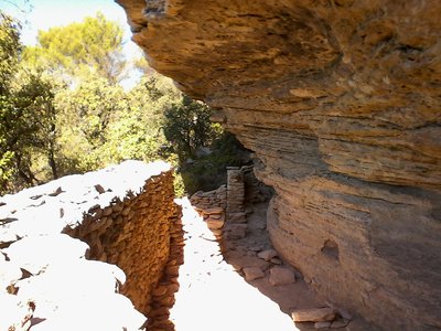
Maison de la Croix des Baux - ©Hélène Fines Patrimony and historyLiving under the rock
Proof of a very active rural life until the 19th century, the Sénancole valley is filled with troglodyte constructions (that is to say, built under the rock) including the house of the Croix des Baux and windmill of Beaume (concealed downstream on the opposite bank). Taking advantage of the natural shelters fashioned by time, a masonry façade was added by man to reduce the volumes and make them habitable.
L'abris sous roche - ©Eric Garnier - PNR Luberon Patrimony and historyShelter for retreat
Under this rock, the members of the Resistance came to find shelter several times, including the night of July 10, 1943 while the Germans were searched one of their wrecked aircrafts fallen over the Sénanque valley.
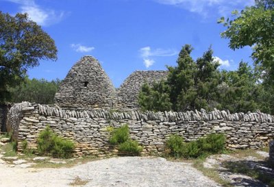
©Village des bories - VPA Patrimony and historyVillage des Bories
Bories are dry stone huts, built without binder or mortar. These temporary shelters for men, tools, crops and animals, were built by farmers with field stones. Round, square or rectangular, their vault is in corbels. Those still standing are not older than 3 or 4 centuries, the older ones would have crumbled following their abandonment. Here, thirty dry stone huts have been resurrected and restored by ten years of work.
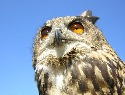
Grand-duc d'Europe - ©PNR Luberon  Fauna
FaunaThe Eurasian-Eagle Owl
The valleys and cliffs of Vaucluse-Monts are home to majestic raptors. They are the territory of the Eurasian-Eagle Owl, the largest nocturnal raptor of Europe (a 1.80m wingspan!). It builds its range in the steep cliffs, where it breeds and rears its young from January to June Like other Luberon raptors, their environment is subject to a prefectural order biotope protection.
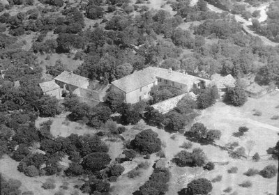
Ancienne ferme de la Débroussède - ©Marie Grenouilleau - PNR Luberon Patrimony and historyFarm of Débroussède
The first major grouping of the Gordian resistance fighters, about thirty men, was initially based here in the spring of 1943, with Felix Poncet who unhesitatingly made his farm available. Their supplies and training were provided by officials of the Secret Army (A.S.). Then, before enrolment growth and the danger of keeping them on for too long, the decision is made to join the Ventoux maquis, more organized and better equipped.
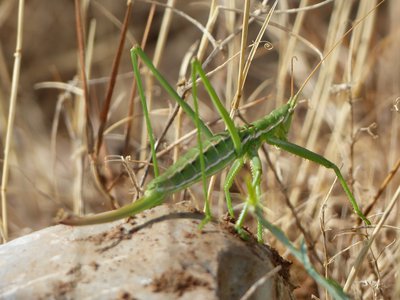
La magicienne dentelée - ©Laurent Michel - PNR Luberon  Flora
FloraThe lawns of the Sénancole
These dry calcareous grasslands were once grazed or even cultivated with lavender. After abandoning these customs, other plants took over these areas like the famous Ophrys Drumana. Roaming through these lawns, there is a procession of butterflies and grasshoppers and it is not unusual to come across the European mantis. Much more rare and very discreet, the Spiked Magician, the longest bush cricket in Europe, also roams the lawns. It is a protected species in France.
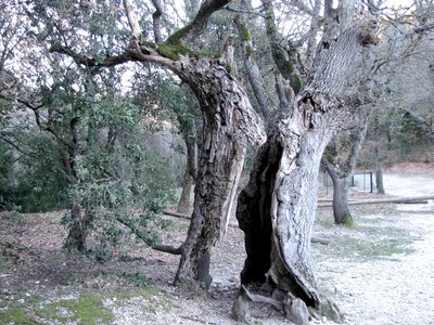
Chêne creux - ©Georges Guende - PNR Luberon FloraHollow oak
This very remarkable old oak has a surprising feature. Its trunk is split in two parts yet it is still alive. 15m high and 5m in circumference, an entire person can go inside.
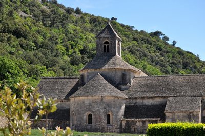
Notre-Dame de Sénanque - ©Daniel Grenouilleau Patrimony and historyThe Sénanque abbey
& Laquo; "Ora et labora"… & Laquo; "Pray and work", such is Saint-Benoît's rule that still governs the daily life of monks in the Sénanque. Built in the 12th century, the abbey is the proof of the spiritual revival of the Middle Ages born at Citeaux in Saône-et-Loire and then spread throughout Europe. Classified as a historic monument, the Sénanque is a remarkable example of Cistercian architecture made of abstinence and simplicity in the image of the spirituality it serves.
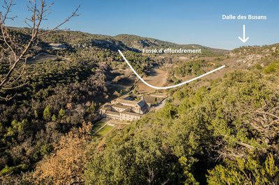
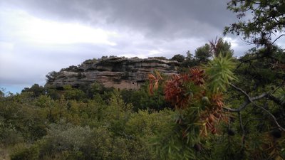
L'abbaye de Sénanque, dans son petit fossé d'effondrement - ©Stéphane Legal - PNR Luberon Geologylimestone slabs and abbey
In the 12th century, Cistercian monks did not go too far to find the stones to build the abbey of Sénanque. This limestone, a microcodium, is the result of the erosion of the Dalle des Busans, upstream, weakened by the Microcodium bacteria 40 million years ago. The fruits of this erosion have accumulated in an ancient lake, at the current location of the Sénanque farm. The monks thus used small quarries to build the abbey.

Messerschmitt Bf 109 - ©DR Patrimony and historyEnemy plane crash
July 10, 1943, a German fighter plane, Messerschmitt Bf 109 model, crashes on the hills of the Sénancole valley. All night, the resistance fighters will hide to prevent German troops from searching for the plane.

Petit-duc scops - ©PNR Luberon FaunaThe Eurasian Scops owl
Unlike the Eurasian Eagle-owl, another emblem of the Luberon, the scops owl is a dwarf. It is also the only owl to migrate to tropical Africa. Active at night, they particularly appreciate the holes of old trees or holes in the walls. In the daytime, it can relax in parks and gardens. This small owl feeds only on insects and lives nearby farms and populated areas.
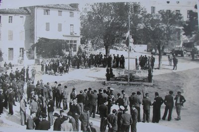
Inauguration de la Maison de la Résistance à Gordes, à la Libération - ©DR Patrimony and historyThe Liberation
After landing in Provence, the resistance fighters grouped into the FFI (French Forces of the Interior) pester the occupier multiplying the raids (military tactics). In retaliation, on August 22, 1944 the "soldiers of Brandenburg" bomb the village, destroying twenty houses. Three days later, on August 25, the FFI regained control of the area and the department of Vaucluse is released.
Description
At the Place du Château (roundabout), go along the north wall of the castle, continue on the left when reaching the Y junction, pass in front of the post office, then continue straight on the Saint-Pons street until the entrance of the cemetery (GR®).). Retrace your steps, pass under the car park and come out on "Route Neuve" (D102). Go up the Baptistin-Picca street on the right.
1 - Near the castle (tourist office), rush into the Rue de l'Eglise. Pass Saint-Firmin's church gate, turn right 20m after the Porte-de-Savoie street and go down the Jean-Deyrolle street to the left (GR®).). Pass the hairpin turn and go up the Bel-Air path. At the top, continue straight, cross the Cavaillon road (D15) and weave in between two walls. Slope down gently and keep going straight.
2 Leave on the right the path leading to the Village des Bories and just after the turn, take a right. Go down to the end of tar and continue straight on the cobblestone path (GR®).). At the bottom of the valley of Sénancole, turn left and then take a quick right. Leave behind the flat path on the left and climb the gravel path across. Pass a house and continue on the track to the left.
3 - At the top, turn left (RP). After the car park of the Village des Bories, go onto a trail along an olive grove on the left. Pass along a large stone wall and continue on the ridge to the right. After two narrow hairpin turns, continue the descent to the bottom of the valley and continue upstream (RP).
4 - At the crossroads "la Senancole", cross the ravine to the left and go up the trail of Grande Combe to the right. Leave a trail on the left (RP) and advance 130m further.
5 - Turn right, leave the valley and climb a rocky path. Once on the plateau, reach the old farm of Débroussède. Continue to the right on a poorly marked trail for about 80m and take a quick right then a left in the valley of La Sénancole. Cross the ford and reach the Senanque Abbey.
6 - Climb the path on the right going above the car park. Turn right and go up the road (GR®).). Go down the road (D177) for 100m and go onto the trail on the right (GR®).). Keep descending straight. Reach a small road. Follow it to the left and reach the Sénanque road (D177).
7 - Take the road (D177) on the right 220m further, then at a lamppost under an oak, turn left and get onto the Gordes road (D15). Turn left, pass the big curve and return to the castle (GR®).).
- Departure : Place du Château, Gordes
- Arrival : Gordes
- Towns crossed : Gordes
Forecast
Altimetric profile
Recommandations
Caution with your ankles on rocky and slippery passages.
Be careful with traffic when approaching Gordes.
The route is signalled at major intersections by arrows with a brown Lorraine cross.
Information desks

House of the Luberon Regional Nature Park
60, place Jean Jaurès, 84400 Apt
In the heart the old town centre of Apt, the House of the Luberon Regional Nature Park welcomes you in a town house of the 18th century. The permanent exhibition of the geology museum has a rich collection of fossils evidencing the geological history of the Luberon.
On sale at the shop: books, maps, guidebooks, games, posters...
Open Monday to Friday from 8:30 am to 12:00 pm and from 1:30 pm to 6 pm (and on Saturday, depending on the program). Free admission.

OTI Luberon Coeur de Provence
Place François Tourel, 84300 Cavaillon
Access and parking
At 18km northeast of Cavaillon, through the D15.
Parking :
Source

Report a problem or an error
If you have found an error on this page or if you have noticed any problems during your hike, please report them to us here: