Aiguebrun valley
« Because of my job and my passion for rock climbing, mountain biking and hiking, there are few corners of the valley that I do not know of.! And yet, I still happen to discover a unique facet. I love the wild side of the place, the beautiful rounded volumes of stones, the tails of the jackdaws, the light sectioned on the ground cover, but also the delicate presence of man at all stages of this paradise.! ». Eric Garnier, Head of Studies for outdoor sports at the Luberon RNP.
26 points of interest

Entrée de Buoux - ©Eric Garnier - PNR Luberon  Patrimony and history
The charm of Buoux
It was in the 17th century that the old village, the small Provençal church and surrounding country houses were built. The small church has a Provençal tabular altar dating back to the pre-Roman era, the present building was probably built after 1704 in the place of a small chapel. In the town hall, an oven dating from the establishment of the village can be seen, it is often repaired and maintained by the commune.
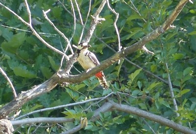
Pic épeiche - ©Laurent Michel - PNR Luberon  Fauna
FaunaTree sheds
With their straight bills, woodpeckers drill through tree barks for nesting purposes or for extracting wood-eating insects (woodborers). In the Luberon, the Great Spotted Woodpecker (black, white with red dots) mixes with the Lesser Spotted Woodpecker (smaller with less red), the European green woodpecker and the Black Woodpecker (rarer, resembles a crow with a red cap). True social housings for insects and bats, these older trees host a multitude of inhabitants in woodpecker holes, the cracks of branches, under the ivy...
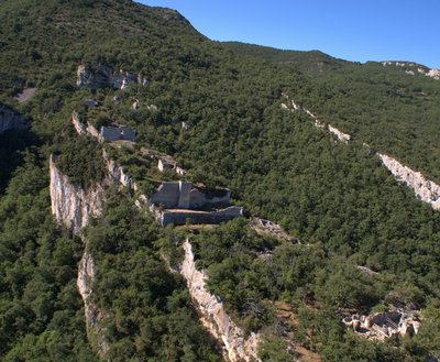
Fort de Buoux - ©Stéphane Legal - PNR Luberon Patrimony and historyThe fort of Buoux
Across, on its rocky spur, the Fort of Buoux has been, for a very long time, the cornerstone of the defence system of all communication through the Luberon. Occupied since prehistoric times, it was fortified in the Middle Ages. Never stormed, it sheltered a garrison and civilians until it was dismantled on order of Louis XIV in 1660, to prevent it from falling completely into the hands of Protestants during the religious wars.

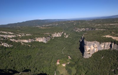
Antoine Le Menestrel dans ''Fissure Serge'' (8a) - ©Eric Garnier - PNR Luberon  Panorama
Climbing the cliffs of Buoux!
To the right, right under your feet, the enormous multicoloured walls and large grey overhangs, naturally riddled with holes of all sizes, have made Buoux a world renown climbing spot. In the 1980s-90s, the cliffs were the laboratory of top international level, where many climbers became famous:; Patrick Edlinger, Antoine and Marc Le Menestrel, Catherine Destivelle, Lynn Hill, etc...
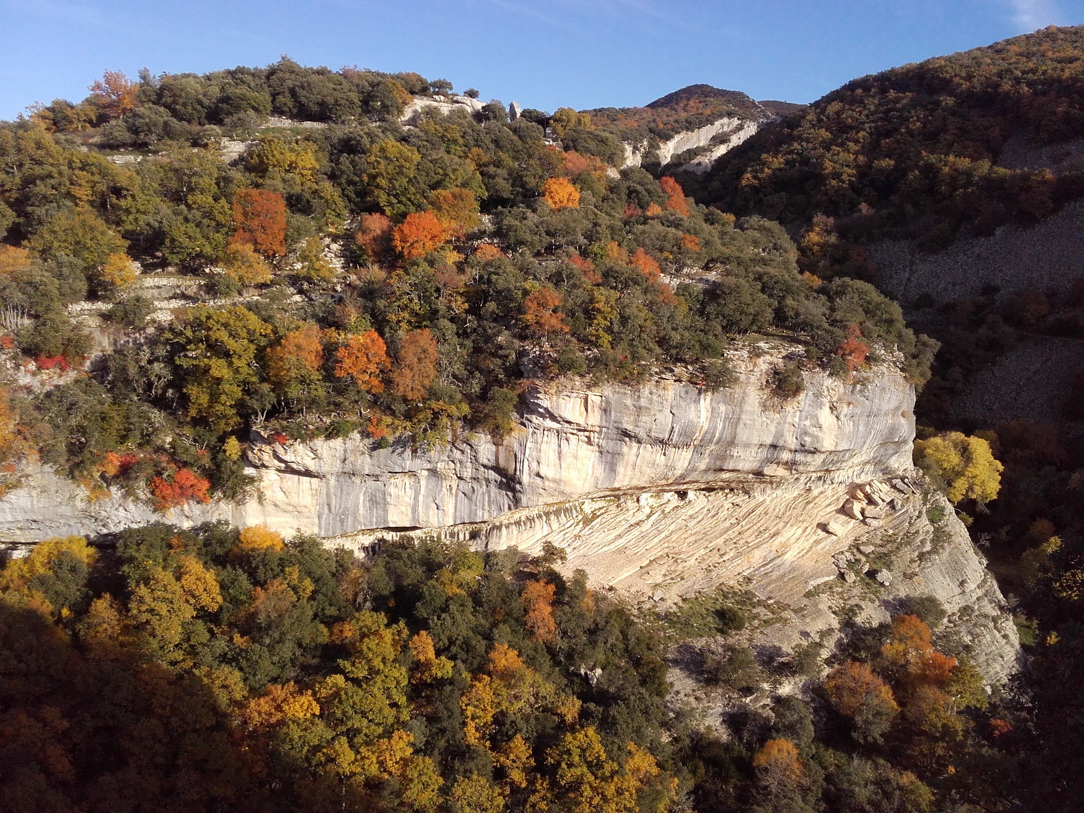
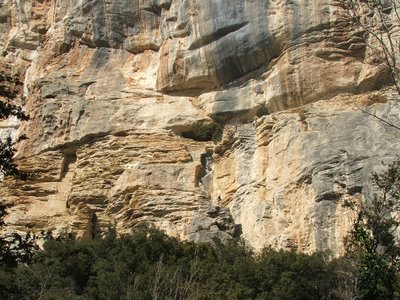
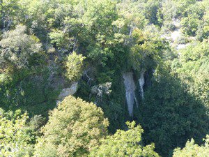
Vue aérienne sur le vallon de l'Aiguebrun - ©Stéphane Legal - PNR Luberon  Geology
The old story of the Gorges
The Aiguebrun valley is distinguished by its high cliffs with limestone escarpments and its chaos of crumbled rocks. The valley grew hollow about 6 million years after the Mediterranean Sea dried out! The water level will be lowered to 1000m and the rivers that surround it will dig huge canyons which are then filled with sediment deposits. Under the action of erosion during glacial periods, the cliffs will no longer be steep.

Le hibou Grand Duc, rapace protégé - ©PNR Luberon FaunaRare raptors protected
Looking carefully, you can spot the presence of protected raptors, remarkable for their size and their cries. The Short-toed Snake Eagle, migratory, nests as of spring on old pines in the forest. European Eagle-owl seeks shelter in the cliffs throughout the year and can be heard at night. Their tranquillity is preserved in sensitive areas: organization of rock climbing, programming of logging outside breeding seasons...

Escalalier dérobé du Fort de Buoux - ©Eric Garnier - PNR Luberon GeologyMolasse or mollasse?
The spectacular cliffs of Aiguebrun are made of sandy limestone (which contains grains of sand) biodetrital (which also contains various fossil debris). Locally, it is called molasses or mollasses according to two possible etymological origins: mola = grindstone, because this abrasive rock was used to produce grindstones. Or mollis = soft, because the rock can be sharpened and be cut easily. This is the noble stone of the quarries of Provence.
Stries dans les falaises - ©Eric Garnier - PNR Luberon GeologyTraces of marine currents!
The surrounding cliffs often have ripples. It's what we call "cross-bedding" or "cross strata". These are evidence of marine origin of these rocks deposited in the sea 20 million years ago, and especially the existence of underwater currents creating a landscape of underwater dunes, embankments and gutters into the depths.

Pont des Seguins - ©PNR Luberon Patrimony and historyPont des Seguins
Several bridges cross Aiguebrun or its tributaries. From Les Près Blancs to Seguin, we can count five of them, including Pont des Seguins, near the inn bearing the same name. It dates back to 1923. It was taken by those who wished to enter the hamlet. It consists of a large main arch that soars over 7m. A small curved opening located in the south abutment allowed the passing of a channel.
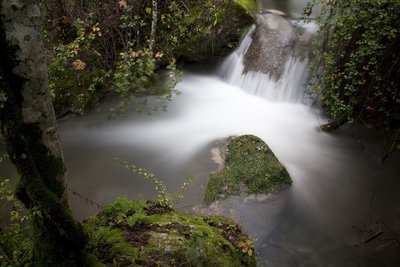
Petite cascade sur l'Aiguebrun - ©David Tatin  Water and rivers
The Aiguebrun river
In the Mediterranean region, very few streams, more or less permanent, are bordered by a lush forest. The Aiguebrun river is one of those and with its valley, is ecologically one of the major sites of the Park. Among the fishes, you may see the Riverine Brown Trout and the Mediterranean Barbel, but also the White-clawed Crayfish, discreet and rare. The presence of these three species emphasizes the health of the aquatic ecosystem, but especially the need to preserve it.
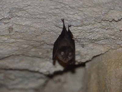
Rhinolophe dans une grotte - ©Laurent Michel - PNR Luberon FaunaI hide in cliffs ...
Bats, also known as Chiroptera are small mammals. Wrongfully hated, they are still mysterious beings able to live up to 30 years and have developed a fabulous echolocation system to find its way at night. This kind of ultrasonic radar bouncing off obstacles and prey also allows them to locate and capture their prey, mostly insects. An individual can consume 30% of its weight in one evening!
Forêt au bord de l'Aiguebrun - ©Laurent Michel - PNR Luberon  Flora
FloraMediterranean Sea, where are you?
Thin and long string of trees subject to the vicissitudes of the river, the riparian forest of Aiguebrun is populated by various wood species such as ash, narrow-leaved ash, common alder, various poplars and willows... It also hosts rare plant species in the Mediterranean region, taking refuge in the cool, damp atmosphere ... The Aiguebrun valley is like a sample of northern Europe which winded up in the middle of Provence!
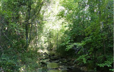
Vue générale - ©Laurent Michel - PNR Luberon  Forest
Ravine forest
Between "riparian forest" (a forested area of land adjacent to a body of water) and rocky ridges, the trail passes through a beautiful forest settled on a steep and rocky slope. If, at first glance, this seems like a "classic", well it's not! This is indeed called a "ravine forest", still very rare and located in Provence. Here, there aren't any oaks (or very few!), you are now in the kingdom of maple, linden and hazel trees and a flora specialised in unstable rocky soils.

Vue sur le village de Sivergues - ©Marion Eyssette - PNR Luberon PanoramaSivergues, at the end of the road
The village is located at the highest point, overlooking the valleys. A sense of calm, isolation, and harmony emerges. The discovery of the village was done gradually, in the form of a big hamlet, it is located on the edge of the plateau. The structure has fitted the topography, giving it a more massive appearance. The layout of buildings and the alignment principle make each built structure open on the valley on the view of the great scenery.
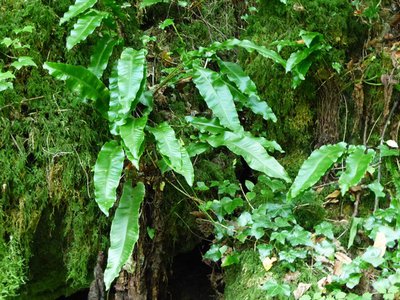
Fougère Scolopendre - ©Laurent Michel - PNR Luberon FloraEach having their exotic qualities
Providing that you are able to climb a few metres of it, this small stream offers the opportunity to observe the Enchanter's-Nightshade (Circaea lutetiana), a discrete plant with small white flowers and strange clubbing sticky fruits and the Hart's Tongue Fern (Asplenium Scolopendrium), which unfolds like a tongue on shaded rocks. Common in well-watered areas, these two species are much rarer under the sun of Provence... (Protected in PACA = picking is forbidden!)
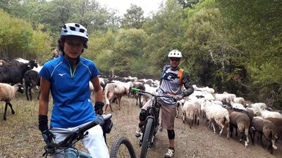
Troupeau dans l'Aiguebrun - ©Eric Garnier - PNR Luberon FaunaFollow me, I'll follow you !
We often hear that if a sheep jumps off a cliff, he will take his entire flock with him, hence the term "follow like sheep". Are sheeps stupid? Researchers have studied the phenomenon, and this group effect is more rational than you think. Sheeps, torn between their desire to find food and to be protected from predators, regroup to explore more effectively blank spaces and circulate information more quickly in case of danger.
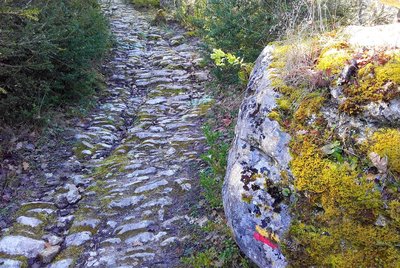
Calade de l'ubac des Perrins - ©Eric Garnier - PNR Luberon Patrimony and historyThe art of the "calade" (cobblestone pavements)
The public roadway heritage still shows remnants of facilities necessary for important human activity in the valley during the past centuries, the cobblestone path portions are the proof. The remains of the calades, pavings with cobblestones placed roughly, can be seen near the passages in the river or when climbing towards the Claparèdes plateau and Sivergues.
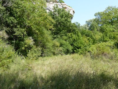
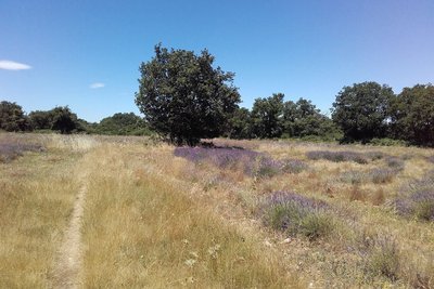
Prairie à l'abandon - ©Laurent Michel - PNR Luberon FloraMeadows, a rare natural heritage
These meadows scattered over the valley bottom are the legacy of the work of nature and man. This well-watered area benefits a wide variety of plants and insects (butterflies, dragonflies ...). And with a little bit of luck, we can flush out a seps, a kind of slow worm with legs ... Grazing has shaped these clearings at a time when small herds could access easily. Targeted bush clearing must be able to restore them while preserving the surrounding riparian forest.
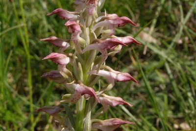
Orchis odorant - ©DR-A. Frangans FloraThe Fragrant Bug Orchid
This small crossing of a slightly wet marl hill may be an opportunity, in the months of May and June, to discover a small vanilla-scented orchid: the aptly named Fragrant Bug Orchid (Anacamptis coriophora subsp. fragrans). Quite rare in France where it is found only in the southern part, it is strictly protected there. So let's carry away her scent in our memories!
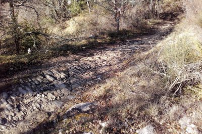
Calade de l'adret de Salen - ©Eric Garnier - PNR Luberon Patrimony and historyThe art of the "calade" (cobblestone pavements)
The public roadway heritage still shows remnants of facilities necessary for important human activity in the valley during the past centuries, the cobblestone path portions are the proof. The remains of the calades, pavings with cobblestones placed roughly, can be seen near the passages in the river or when climbing towards the Claparèdes plateau and Sivergues.
Pas dèi ensarris - ©Eric Garnier - PNR Luberon Patrimony and history"Lou Camin Salié"
& Laquo; "Lou Camin Salié" or salt road were the roads used formerly by salt merchants with their caravans of mules from the Etang de Berre. A popular condiment at the time, you had to be cunning and clever to avoid thieves and bandits. Thus, merchants passed through less accessible but more secure paths. A former salt road, the path you are currently on came from Sivergues to reach Apt through this place called "Salen", to the left.
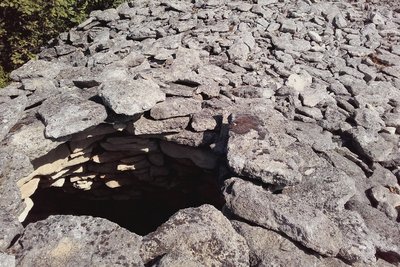
Abri en ruines dans un clapàs - ©Eric Garnier - PNR Luberon Patrimony and historyThe Claparèdes plateau
Claparèdes comes from "clapàs" which means piles of stones in Provençal. The peasants have always collected the stones from the fields to improve their land, they remained in heaps or were used for dry stone constructions. Many bories and low walls are present on this part of the plateau which extends between Saignon and Auribeau. La Gardette, former cereal land, is now heavily invaded by woods.
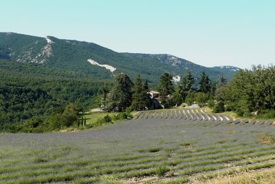
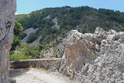
Ferme de Salen et Grand Luberon - ©Françoise Delville - PNR Luberon PanoramaA postcard scenery...
The Luberon is visible from everywhere and very present in the landscape. It is also a wonderful spur which reveals wide panoramas of Mont Ventoux and the Alps to the north from the Claparèdes plateau. Do not miss the purple mottling of the lavender from June to July. Contemporary human presence is rare but the few farms, bories, dry stone walls resulting from field stone removal are the proof of an earlier human presence.
Forêt, pelouse et culture sèche des Claparèdes - ©Eric Garnier - PNR Luberon  Elevage et pastoralisme
Long live the diversity, long live Life!
Dedicated to a traditional agro-sylvo-pastoral system, the Claparèdes plateau is divided between forests, lawns and dry crops, but also groves surrounded by hedges of old trees, including almond trees and mulberries, witnesses of a past culture. The interface and transition zones between all these ecosystems (ecotonal zones) are very favorable to a diversified fauna: birds such as the lark lulu and the sparrow zizi, but also reptiles such as the grass snake, the worm and the ocellated lizard.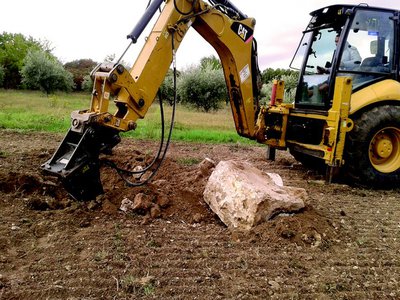
Extraction de pierres - ©Magali Amir Patrimony and historyStones, a true nightmare for farmers!
The small stone huts or bories you see everywhere in the Luberon were built with stones extracted from the fields by the farmers at the time. Today it is still the same problem for farmers of the Luberon, who have to clear their fields of stones several times a year. And even if the sale of stones allows them to earn some money, these stones are a scourge for agricultural equipment, breakage and wear being common.!

Lavandin du plateau des Claparèdes - ©PNR Luberon FloraLavender or lavandin?
Spike Lavender (commonly known as French Lavender) (Lavandula latifolia), with broad white leaves, is a Mediterranean plant. The English lavender (Lavandula angustifolia) with narrow leaves, is more of a mountainous plant (up to 1500m). Although the English lavender is sometimes cultivated in the mountains, it is usually the Lavandin, a hybrid of the two species and more productive, that we see in the fields. Warning, these crops are the result of hard farm work, please do not pick!
Description
Go right on the D113 and turn left. Outside the town hall, go straight. At the corner of the inn, go down to the left. Come out on the D113 (traffic!), cross the bridge and go left until the hamlet of Deyme. Continue on the dirt road, then rise slowly towards the plateau.
1 - At the crossroads"Les Ramades'', turn right and descend to the cliff edge. Continue left on the trail that winds over the void. Further down, turn right and descend the hairpin bends"Chemin dei frau", formerly in cobblestone (careful, the GR® cuts the 1st turn). At the bottom of the hairpin bends, take a right. At the next intersection, turn left, cross the bridge and go up across.
2 - At the crossroads"Aiguebrun'', turn left, then 30m further, turn left towards"Sivergues''. After a succession of steep paths and small descents, spot on a flat stone the sign"Sivergues''. Leave the banks of the Aiguebrun and rise gradually. Continue on the rocky path until the town of Sivergues.
3 - Climb the cobblestone across. Turn left and reach the entrance of the village. At the car park, take a left onto the Chantebelle track and at the 1st turn, continue straight on the path. Skip two corners and continue down the gravel path. Pass a cobblestone section and reach to the valley bottom. Go to the right, cross the ford of Aiguebrun and go up the opposite bank. Pass a cobblestone section and continue across on the rocky path. Pass a corner on the left then turn right at the next intersection. Go up the trail that weaves through the horse paddock. Reach the plateau and continue across on the shaded path that passes between old walls.
4 - At the crossroads"Barbe Blanche", turn left and take the small road through the Claparèdes plateau. At the crossroads"Chante Duc", continue straight, hurtle down 3 hairpin bends and continue to Buoux.
- Departure : Car park of the village, Buoux
- Arrival : Car park of the village, Buoux
- Towns crossed : Buoux, Sivergues, and Saignon
Forecast
Altimetric profile
Recommandations
- after point 1: passage on the edge of the void.
- between points 3 and 4: a ford.
Caution with your ankles on the numerous cobblestone and rocky areas.
Information desks

Luberon UNESCO Global Geopark
60, place Jean Jaurès, 84400 Apt

House of the Luberon Regional Nature Park
60, place Jean Jaurès, 84400 Apt
In the heart the old town centre of Apt, the House of the Luberon Regional Nature Park welcomes you in a town house of the 18th century. The permanent exhibition of the geology museum has a rich collection of fossils evidencing the geological history of the Luberon.
On sale at the shop: books, maps, guidebooks, games, posters...
Open Monday to Friday from 8:30 am to 12:00 pm and from 1:30 pm to 6 pm (and on Saturday, depending on the program). Free admission.

OTI Pays d’Apt Luberon
788 avenue Victor Hugo, 84400 Apt
Du 1er avril au 30 septembre
Ouvert du lundi au samedi de 9h30 à 12h30 et de 14h à 18h.
Juillet et août : Ouvert dimanche et jours fériés de 9h30 à 12h30
Du 1er octobre au 31 mars
Ouvert du lundi au mardi et du jeudi au samedi de 9h30 à 12h30 et de 14h à 18h.
Fermé le mercredi, dimanche et jours fériés.
Access and parking
At 8km south of Apt by the D113 and 12km north of Lourmarin by the D943 and D113.
Parking :
Access
- Emergency number :
- 114
More information
Source

Report a problem or an error
If you have found an error on this page or if you have noticed any problems during your hike, please report them to us here: