The Rochers des Mourres
« Heads, mushrooms, arches or bridges ... We do not know on who to rely on! As an artist, erosion has washed away the softer rocks and then patiently perfected the limestone which was less soft to generate strange forms. An arid area, Mourres is also an environmentally sensitive area (ESA), where the flora and fauna adapt to drought.. Stéphane Legal, geologist at the Luberon RNP.
12 points of interest
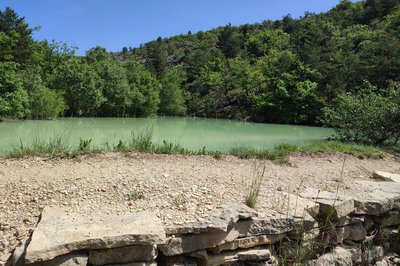
Retenue du Grand Travers - ©Eric Garnier - PNR Luberon  Water and rivers
Blue gold
Here, between Forcalquier and the Lure mountain, water has always been a scarce resource. As a drier land than the neighbouring ones, man has had to work twice as hard to meet their needs and those of animals and crops. In this way, wells, cisterns, underground tanks, aqueducts or fountains mark the land. They are self-evident arrangements made by man to get this precious water flowing.
Montagne de Lure - ©OTI-PFML  Patrimony and history
The "Blue Mountain"
This is the nickname given by Jean Giono to the Lure mountain. It lets all four seasons wander through. Cool valleys and sunny lawns for exceptional hiking on sunny days and snow activities (skiing, snowshoeing, sledging (UK) / sledding (US)...) in winter. The Lure mountain offers many things to do all year round.
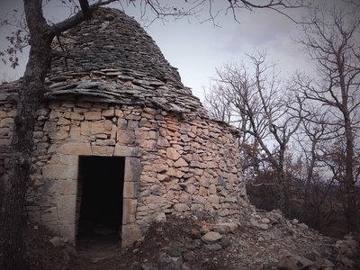
Borie - ©Eric Garnier - PNR Luberon Patrimony and historyLong live the dry stone!
In Forcalquier, they can't be missed! Small walls, pens, retaining walls for terrace fields, or weird huts (bories). They are everywhere! The construction of these small dry stone structures began when man had to clear his land of stones in order to cultivate it. So what to do with this excess of stones? From there came the idea to pile them up in order to build pens, tame slopes or make shelters for men and tools.
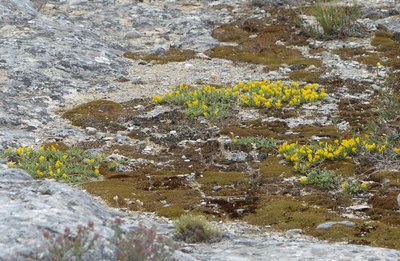
Genêt de Villars - ©Laurent Michel - PNR Luberon  Flora
FloraSmall garrigue (scrubland) in Genêt de Villars
On this arid soil, you can see a discreet broom (shrub) against the ground: Villars broom (Genista pulchella subsp. villarsii). Its meagre look is an adjustment to sunny and dry environments: It sweats very little! Sharing space with some species which are also frugal, the Villars broom is the structuring element of a natural environment, rare and protected by Europe: from "heath to Villars broom".
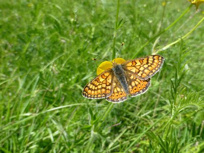
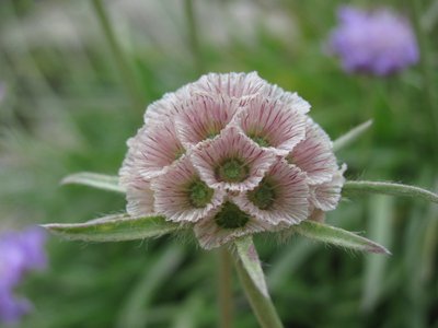
Damier de la Succise - ©Laurent Michel - PNR Luberon  Fauna
FaunaThe Marsh fritillary
The Marsh fritillary (Euphydryas aurinia subsp. provincialis) is a butterfly named in French after its orange chequered pattern on its wings. As for the Devil's-bit scabious, it is one of the host plants for the caterpillar form of the Marsh fritillary. Although it is present in most of the country, the Marsh fritillary is usually rare and localized. In Provence, the subspecies "provincialis" is relatively common in places like Mourres and can be seen around April-May. This butterfly is protected in France.
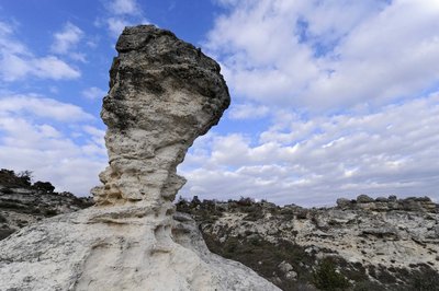
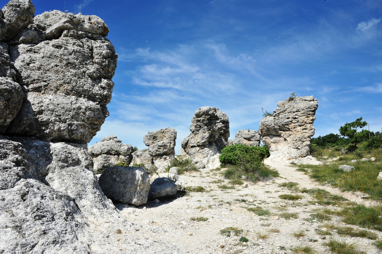
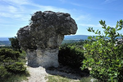
Cylindre des Rochers des Mourres - ©Vincent Damourette - SIPA  Geology
Heads? Mushrooms? Les Mourres!
What a strange landscape! With an unusual appearance, you can get a glimpse of heads, giant mushrooms, arches and bridges ... These are Les Mourres! A classified site resulting from the erosion of Miocene calcareous marl, here, fauna has managed to adapt to drought.
Rochers des Mourres - ©Atelier Photo-Graphique - OTI PFML GeologyUnusual structures of Mourres
The Rochers des Mourres look like mushrooms with a friable clayey-limestone base and a hard and even limestone cap. These structures were formed by the stabilisation and the encrusting of calcareous sediments through aquatic grass and green algae on lakefronts, 25 million years ago. They have been growing vertically, following the fluctuations of the water level. The shaping of these sculptures so beautiful of Mourres are due to erosion.
Scabieuse à feuilles de graminée en fruits - ©Laurent Michel - PNR Luberon FloraThe grass-leaved scabious
True local star, the grass-leaved scabious (Lomelosia graminifolia) is a plant found in the mountains of southern Europe. One can easily recognize its linear leaves such as grasses (its name has not been usurped!), by its beautiful blue flower heads blooming in late spring and summer, then by its fruits agglomerated into as many silver "cups ".
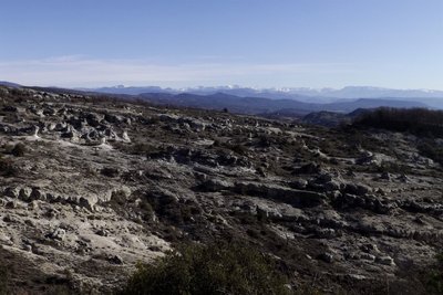
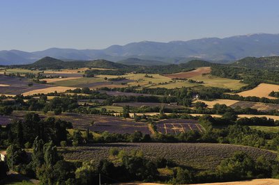
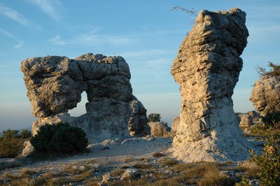
Les Alpes depuis les Mourres - ©Françoise Delville - PNR Luberon  Panorama
A ruiniform landscape
The ruiniform landscape (presenting the appearance of ruins) with unusual and unique shapes, allows everyone's imagination to drift leisurely. This intimate site, perfect for strolling, also opens up, for viewing pleasure, to a clear view, stumbling far away on the ridge of the Alps and the Lure mountain.
Paysage d'inspiration - ©Jacques Honoré - OTI PFML Patrimony and historyLes Mourres, an inspiration for writers
These rocks, formed like heads, mushrooms, arches or bridges, have often inspired local writers by their strange appearance. Eugène Plauchud wrote, in Provençal, that they were men of stone. For Camille Arnaud, writing in French, they were the campsite of the Emir of the Moors. More recently, Georges Lautner shot there one of his films based on Pierre Magnan's novel, "La Maison assassinée"».
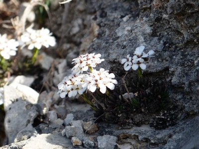
Iberis des rochers - ©Laurent Michel - PNR Luberon FloraA little trip to Iberia
Often blooming from March, the Rock candytuft (Iberis saxatilis) is a subshrub (or dwarf shrub) recognizable by its white flower heads with its outer petals much larger than the others. Its species name ("saxatilis") represents it well because it is found clinging to the limestone rocks. Besides, it is the host plant of the caterpillar of a rare butterfly: : the Portuguese dappled white (Iberochloe tagis). This little butterfly with green and white marbled wings flies from February to June.
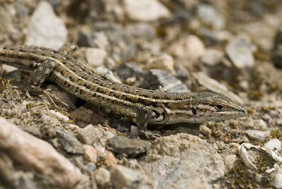
Psammodrome d’Edwards - ©DR-Benny Trapp FaunaThe Common wall lizard or the Spanish psammodromus?
Strolling through these paths, you can come across a look-alike of the common wall Lizard, tumbling down a bush.. Also brown, the Spanish psammodromus strangely resembles its cousin but when you look closer, it has four dark streaks with black spots on its back. Extremely fast, it likes to hide under dead leaves or sand and screeches when its caught.
Description
With your back turned to the tourist office, at the Bourget town square, go left on the Marcel-André avenue and go straight until the intersection of the Route de Fontienne (D12). Continue across on the Saint-Marc avenue (RP). At the end of the 1st curve, go slightly to the right into a narrow street. Exceed the water tower that points to the left and cross a narrow passage between two walls. Turn right before the Saint-Marc chapel. Remain to the right on the ascending path. Pass the last houses and 200m further, go left to follow the trail that goes below the aerials (antennas). Reach lower down the crossroads "La Parise".
1 - Continue straight. Quietly go up the trail, continue on a wider path and reach the crossroads "Le Grand Travers." Continue straight, pass the information panels and 70m further, reach the the crossroads of Mourres to the right.
2 - Turn right and follow carefully the markings of the path between the rocks. Go towards the left and then down to the car park at the roadside (D12). Cross the road and go across on the path descending downstream on the Mourres site. Further down, do not to miss the path on the right (signpost). Reach the bottom of the ravine and cross. On the other side, advance 50m left on a clear path, then turn immediately right to climb the stony steep path (marking barely noticeable). Go up the winding paths and come out on the road. Go across and reach the crossroads "Ravin de La Parise" just above.
3 - Take a sharp left, out on the D12, take a left turn on 250m in front of the farm. Lower down at the next intersection, continue down to the right along the olive groves and the cemetery to come out on Chemin des Moureisses. Go straight down, reach the Fontauris avenue. Turn right, go past a nursery school then turn left onto the L. Andrieux to return to the Bourget town square.
- Departure : Tourist Office, Forcalquier
- Arrival : Tourist Office, Forcalquier
- Towns crossed : Forcalquier
Forecast
Altimetric profile
Recommandations
Caution with your ankles on the rocky areas. Make sure to stay on the track of the trail. ; The Mourres site is very sensitive to erosion. Refrain from any picking (flora, fossils).
Information desks

Luberon UNESCO Global Geopark
60, place Jean Jaurès, 84400 Apt

House of the Luberon Regional Nature Park
60, place Jean Jaurès, 84400 Apt
In the heart the old town centre of Apt, the House of the Luberon Regional Nature Park welcomes you in a town house of the 18th century. The permanent exhibition of the geology museum has a rich collection of fossils evidencing the geological history of the Luberon.
On sale at the shop: books, maps, guidebooks, games, posters...
Open Monday to Friday from 8:30 am to 12:00 pm and from 1:30 pm to 6 pm (and on Saturday, depending on the program). Free admission.

OTI Forcalquier-Montagne de Lure
13, place du Bourguet, B.P. 15, 04301 Forcalquier
Transport
Access and parking
At 23km north of Manosque, through the D13.
Parking :
Source

Report a problem or an error
If you have found an error on this page or if you have noticed any problems during your hike, please report them to us here: