
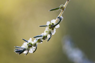
La Virginière
& Laquo; I love this amazing intrusion into the meanders of Calavon-Coulon, a river that was once dried out by man and now revived. Between alluvial forests and pebble benches, it's possible to come across some of the 80 species of birds registered, such as the Common Kingfisher, the Golden Oriole, the Grey Heron... You will also glimpse the tangible evidence of the presence of the craftsman of the area and Europe's largest rodent: the Beaver& Raquo;. Jerome Brichard, River Technician at the Luberon RNP.
21 points of interest
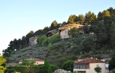
Habitat troglodythe des Beaumettes - ©Daniel Grenouilleau  Patrimony and history
Troglodytes (underground dwellings) of Beaumettes
Just above the village, the troglodyte site of Beaumettes is part of the most famous sites of the Vaucluse. These underground structures lining up on nearly 130m represent a real little hamlet. Houses, farming outbuildings including a dovecote, ponds and cisterns are built around a castle and the Romanesque chapel of Sainte-Foy. There are 3 types of troglodytes: the closing of a natural orifice, constructed caves (the case in Beaumettes) and sheltered structures built against a hill.
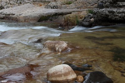
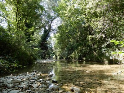
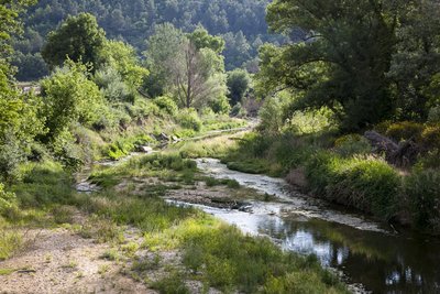
L'eau précieuse du Calavon - Coulon - ©Léa Samson - PNR Luberon  Water and rivers
The Calavon, rebirth of a river
Until 1992, the Calavon was presented as one of the most polluted rivers in France, mainly by the industrial waste of food-processing factories of Apt. Since then, thanks to the joint efforts of all water users who rallied for a coherent and overall river management, this river which was once "murdered" is now revived. Its inclusion in 2005 in the European network Natura 2000, identifier of important natural sites for biodiversity, goes in this direction.
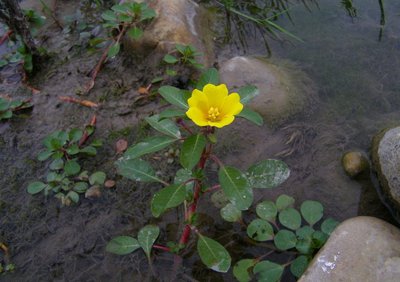
Jussie en fleur - ©DR-M.T. Ziano  Flora
FloraThe Water Primrose, a nuisance plant
Exotic species introduced into an ecosystem, sometimes unintentionally, represent the third cause of loss of biodiversity. The Calavon river is here affected by the Water Primrose, an aquatic plant from South America. It spread in Europe in the 19th century through ornamental ponds where it was used as an ornamental species for its yellow flowers. Very invasive, it hinders the circulation of aquatic fauna, eliminates aquatic plant habitats, and can cause aquatic asphyxiation.
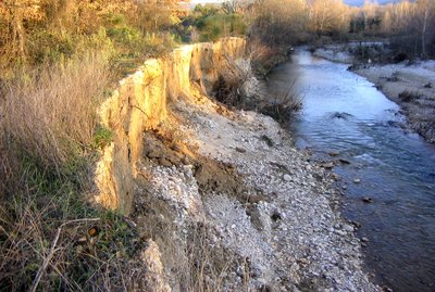
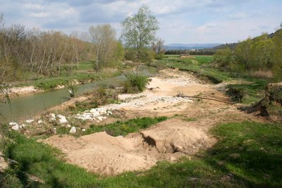
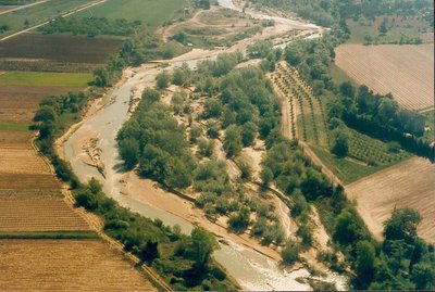
Erosion des berges - ©Jérôme Brichard - PNR Luberon Water and riversA dynamic river
The river, a dynamic environment, changes over time and space. It is constantly trying to dissipate its energy by eroding its banks and depositing material where the flow is low. This active strip creates diverse habitats for many species. Since 1944, its surface was reduced on average by 40% on the Calavon because of former gravel extraction activities. Its bed therefore sunk 2m, 4m locally, leaving the bedrock appear sometimes.
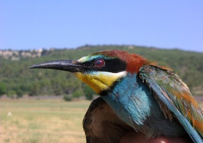
Guêpier d'Europe - ©Amandine Marie - PNR Luberon  Fauna
FaunaThe African hunter
A migratory species of Africa, the European Bee-eater breeds in Luberon from May to September. Colourful birds, it hunts from a lookout, often waiting in groups on power lines. It catches insects, mostly Hymenoptera (bees, wasps) but also dragonflies, cicadas, butterflies. An individual can eat up to 250 bees a day! The European Bee-eater nests here in the banks of the Calavon where it found the right conditions to dig a long tunnel.
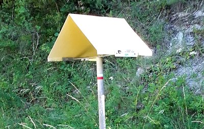
Signalement de la conduite de gaz - ©Jérôme Brichard - PNR Luberon  Savoir-faire
There's water in the gas!
Along the way you may have noticed the yellow milestones, sometimes topped with a "hood" which may look like feeding boxes for birds. It is not so! It is the materialisation, particularly for air traffic controls, of the passage of the main gas line which supplies the Apt valley. But on this site, GRT GAZ contributes to the preservation of the natural environments of Calavon, by supporting the Luberon Park in the land acquisitions of parcels bordering the stream.
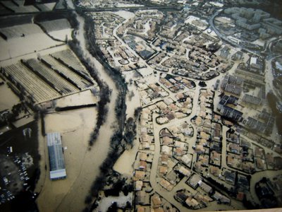
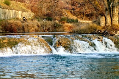
Inondations à Cavaillon en 1994 - ©Gilles Brière - PNR Luberon Water and riversThe riverbeds
The channel bottom of a river is called bed. The flow rate (amount of water that passes a point in a given time) vary throughout the year. The minor riverbed is the physical confine of the normal water flow. The moderate bed corresponds to the non-overflowing floods, contained by the higher river banks. The major bed is the rise in water level overflowing its banks and flowing onto its flood plain. Preserving these beds is essential to slow down the water in order to protect the urban areas against flooding.
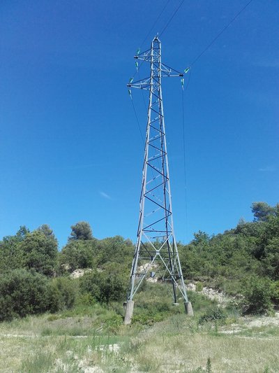
Pylône RTE - ©Jérôme Brichard - PNR Luberon Savoir-faireWhen electricity rhymes with biodiversity
Here the high voltage line Apt - Cavaillon crosses outstanding natural environments of Calavon. The management and maintenance of vegetation in and around the electrical works are for Réseau Transport Electrique a major technical and environmental concern. Therefore, the Luberon Park and RTE are working together to restore the site in order to reconcile the safety of the electrical grid and the preservation of the biodiversity.
Verrou de Lumières - ©Eric Garnier - PNR Luberon  Geology
The barrier of Lumières
From here, you will be overlooking the valley floor of Calavon dominated by the presence of natural environments (alluvial forest and pebble banks) shaped by the river at the whim of floods. There at the Hameau de Lumières, the plain bears the marks of the narrowing hilly area, creating a barrier effect. The slopes are made up of a sandy limestone of marine origin: molasse. It was formed 20 million years ago when the Mediterranean sea went up the Rhone Valley.
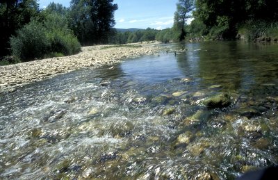
Ripisylve - ©PNR Luberon Water and riversA riparian forest, what is it?
A wide riparian forest is developing on the opposite bank. This Latin word comes from "ripa" meaning bank (river), and "sylva" forest. This wetland vegetation is characterized by the presence of the soft wood trees such as willows and poplars of which the Beaver is very fond. It is essential to the proper functioning of rivers by acting as shade, sewage, soil protection as well as refuge and food source for many species.
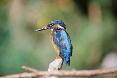
Martin pêcheur - ©Fabrice Teurquety FaunaEighty !
The number of bird species documented on this site through monitoring conducted each spring. Of these, 40 are nesting. Most are typical of the riparian forest of the river and its banks: Kingfisher, Golden oriole, Grey heron... The latter is easily recognized by its large size, its grey plumage, its slow and powerful flight and his neck bent into an "S". These bird populations are very sensitive to any disruption of the area, so hush!
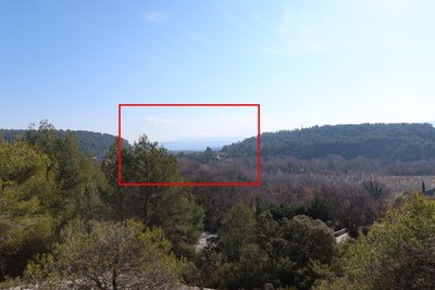
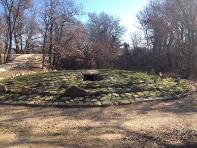
Fouilles archéologiques de La Virginière - ©Jérôme Brichard - PNR Luberon Patrimony and historyPrecious archaeological excavations
The excavation located below is the original site of the Neolithic dolmen reconstructed 500m upstream, away from the Calavon floods. The flood from 1994 had uncovered it due to the erosion of the banks which were pushed back here at 40m over a distance of 150m. Located on the north-facing slope, this tomb dating back to 3000 BC contained fifty individuals of all ages and gender, buried in a contracted position, the legs folded and brought close to the torso.
Dolmen après restauration - ©Pierre Prouillac - PNR Luberon Patrimony and historyThe neolithic dolmen
At the foothill is the reconstitution of the dolmen discovered500m downstream during the flood of 1994. The original monument forgotten, was covered with silt for centuries and therefore well preserved. Then, after 2014, too exposed to successive floods, in 2013- 2014, it was fully moved, stone by stone, after numbering and carefully disassembling them. This structure is the second of its kind in the Vaucluse after the one in Ménerbes, and one of the few in Provence.
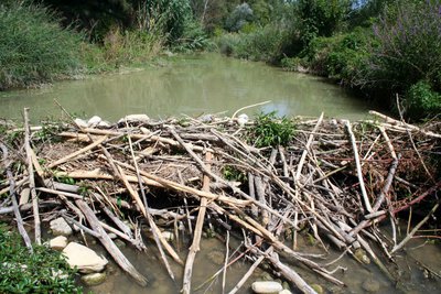
Barrage du Castor d'Europe - ©Jérôme Brichard - PNR Luberon FaunaThe lumberjack of rivers
Its nocturnal habits make a of the Beaver a discreet host of the rivers, where only the marks of its lumberjack activity betray it. Recognizable by its stocky shape and flat tail, it is a vegetarian and feeds particularly on willow and poplar. Building dams during droughts, it is very useful in the preservation of wetlands. With its 30kg, it is the largest rodent in Europe. Protected since 1968, he re-colonised the Calavon where a hundred individuals are identified.
Calavon ou Coulon ? - ©DR-Robert Caracchioli Water and riversCalavon or Coulon?
The Calavon is also called Coulon downstream of Apt. The geographical limits of use of the name Coulon is set here in the Commune of Goult where one of its tributaries reaches upstream of the bridge: L'Imergue. Spelled "Limergue" until the early 20th century, it comes the Latin word "Limés" which means the limit. This river was considered, from late Antiquity to the Middle Ages, as a border between the two influencial linguistic areas and the Contat Venaissin.
L'eau est d'or - ©Hervé Vincent Water and riversAqui l'aigo es d'or! (Here the purest water is gold!)
The Calavon often goes through droughts. In addition to the dry climate, 45% of its drainage basin does not contribute to the flows of the river. The water seeps into the Karst (porous limestone) and comes out at the Vaucluse fountain. To this loss of water you may add water drawing for a household, agricultural or industrial use. Through its regular monitoring of the flows, the Luberon Park participates in Prefectural decisions on drawing restrictions. Let's save water, every drop counts!
Bassie à fleurs laineuses - ©David Tatin FloraThe steppes of Calavon
The alluvial terraces bordering Calavon are colonised by herbaceous plants including the rare and protected Sand bassia. This steppe species of sandy areas seems to keep up in France only in the Vaucluse, especially in the Calavon between Apt and Robion (15 known sites of the 19 in France). Here, just below the path, a program for the reinforcement and the monitoring of its populations is implemented on the grounds of the Luberon Regional Nature Park.
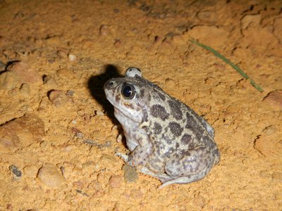
Pélobate cultripède - ©Jérôme Brichard - PNR Luberon FaunaWhen toads will have blades...
This is already the case.! With the European spadefoot toad and its hen-like singing. With its rooster-like spurs in its hind feet, it hides in the sand until it rains! A rare and vulnerable species in France, considered near threatened globally, the Luberon Park restored breeding ponds for the species in the reed bed located just below.
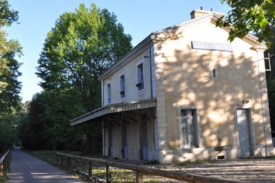
Ancienne gare de Goult-Lumières - ©Daniel Grenouilleau Patrimony and historyGare de Lumière
The station, now a town housing, is proof of the railway line connecting Cavaillon to Volx built under the Second Empire. 78km long, it required not less than 3.5 hours to connect the two terminals. During the 20th century, the sections closed one by one. The Cavaillon-Apt section, passing through this station, ceased operating in 1989. A pilgrimage site, the Gare de Lumières saw many pilgrims disembark during its years of operation.
Couloir de liberté - ©Gilles Brière - PNR Luberon Water and riversThe area of freedom of the river
In the alluvial plain, due to the floods, the Calavon can shift its bed onto a "corridor" called area of freedom. These shifts by soil erosion can slower the water and are the sources of the ecosystem diversity. Too often, man has obstructed this lateral mobility by keeping the river in a constrained manner with rip-rap or embankments. Preserving, and even restoring, this area contributes to a good water status and the protection against flooding.
Zone humide du Calavon - ©David Tatin Water and riversa wetland is a needed area: let's take action!
The wetlands of the Luberon are rare and are represented mainly by rivers that constitute biodiversity oasis. In France, half of the wetlands have disappeared during the 20th century. Yet they offer many free services: water storage, purification, protection against soil erosion, slowing down flows. They also play an important role in the local economy and the attractiveness of the area (agriculture, leisure activities,). Let's protect them!
Description
Cross the underground passage, continue straight on the road to Ménerbes (D27), pass the bridge over the Calavon-Coulon.then continue on the road 270m.
1- At the corner of the first house, turn left onto the paved path "Chemin des Alafoux" (pole). 500m further, turn left on the dirt road. 100m further, leave the farm road to engage on a path on the edge of banks in the undergrowth (marking hardly noticeable). Come out on a track and go straight. Continue on the path, switch to the other side of the meander and after a left turn at the corner of a farm, reach the Route de Lacoste.
2- Go across on the road (D218). At the end of the straight line, go past the entrance of a farm (wind farm) and at the exit of the curve, take a left onto the dirt road. Pass the dolmen and climb the hill to reach the long-distance cycling route.
3- Turn left and follow the EV8 to the village of Beaumettes. At the exit of the small car park, go back under the underground passage to return to the Town Hall Square.
- Departure : Les Beaumettes
- Arrival : Les Beaumettes
- Towns crossed : Beaumettes, Ménerbes, and Goult
Forecast
Altimetric profile
Recommandations
Be careful on both road sections; continuing on the left side of the road (in the direction of travel), facing the vehicles, may be preferable. Be careful also on the long-distance cycling route: Lots of bikes may surprise you from behind.
Do not move too close to the edges of the banks because of the risk of subsidence. Remain discreet to enjoy birdwatching.
Be careful if you are travelling with a stroller; paths on the first part of the route are rocky!
Information desks

House of the Luberon Regional Nature Park
60, place Jean Jaurès, 84400 Apt
In the heart the old town centre of Apt, the House of the Luberon Regional Nature Park welcomes you in a town house of the 18th century. The permanent exhibition of the geology museum has a rich collection of fossils evidencing the geological history of the Luberon.
On sale at the shop: books, maps, guidebooks, games, posters...
Open Monday to Friday from 8:30 am to 12:00 pm and from 1:30 pm to 6 pm (and on Saturday, depending on the program). Free admission.

OTI Luberon Coeur de Provence
Place François Tourel, 84300 Cavaillon
Access and parking
At 15km east of Cavaillon, taking the D15 and D900.
Parking :
More information
Report a problem or an error
If you have found an error on this page or if you have noticed any problems during your hike, please report them to us here: