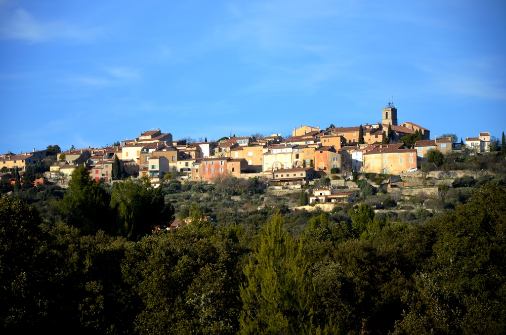
The hilltop village of Jean Giono
"I was doing this reflection on the terrace of a house at the top of Saint-Julien-le Montagnier, the forest of oaks closely encircles the foot of the rock that carries the village. It extends over a good hundred square kilometers. It is seen from above, crossed by a deserted road, in a straight line, spinning towards the massive bronze which on the horizon separates this country from the sea. " Jean Giono
12 points of interest
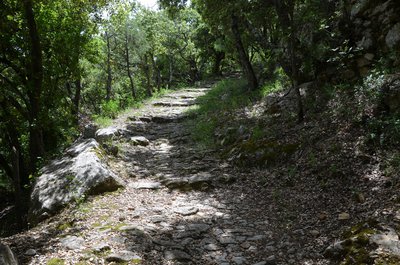
Chemin du paradis des Ânes - Stefano Blanc - PNR Verdon  Patrimony and history
The way to the paradise of Donkeys
This path is quite steep. Half way a flat and shady part was appreciated by the donkeys and their masters who caught their breath! The stony and sloping land, now wild, has harvested almonds and olives. In the saffron trees we cultivated the "crocus sativus" whose stigmas (saffron) brought back big.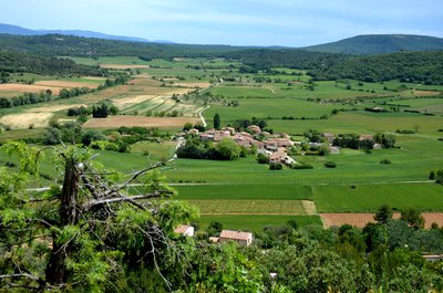
Vue sur les Guis - Stefano Blanc - PNR Verdon  Panorama
The Guis hamlet
The village perched on an isolated hill offers a beautiful view of a succession of rocky plateaus covered with scrubland. Fields of vineyards, cereals, lavender and olive trees bring each season the dominant colours of a changing landscape and a view of several of the 27 hamlets that are on the municipality.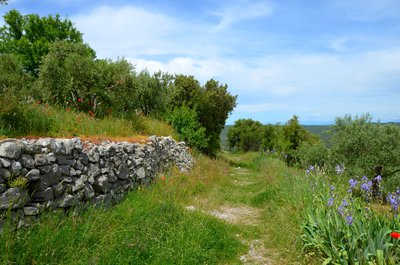
Le chemin du Baou - Stefano Blanc - PNR Verdon Patrimony and historyThe Baou path
Called Chemin de Gréoux, it was one of Saint-Julien's main carter accesses. At the beginning of the last century, it was used by women who went to the fountain to do their laundry. Running water did not reach the village until 1965. The observation of the limits of the fields in the lowland suggests the old Roman land registry.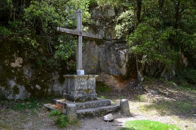
La Croix - Stefano Blanc - PNR Verdon Patrimony and historyThe cross
In the 19th century, there were many Catholic missions in which women participated. At the end of each period of religious practices, a cross was erected. The latter was in 1827. Descending the path we arrive at the fountain. The black marks on the ground are reminiscent of the coal mines exploited in the 19th and early 20th centuries.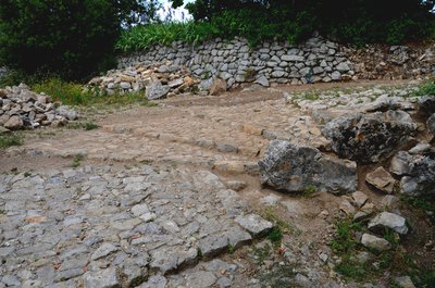
La calade - Stefano Blanc - PNR Verdon  Savoir-faire
The calades, what is this?
The calade is a technique for the gravelling of soils in which the material is the stone, the more often picked up locally. The stones are sunk vertically. It is said then that it is a standing ground to distinguish it from pavement which is a lying ground. Stoned paths were among the main accesses to the village. They allowed to mount all the necessary goods and on a daily basis, the most precious of all: the water.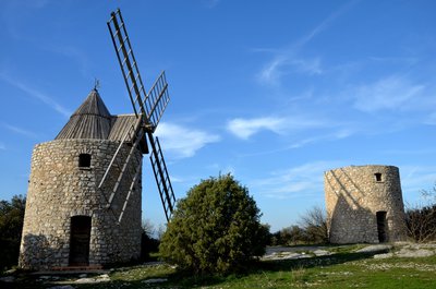
Les moulins à vent - Stefano Blanc - PNR Verdon Patrimony and historyThe windmills
In the seventeenth century. we also see the construction of two windmills.in the area of Gourdane (also rightly called the Area of the End of the World) The municipality had until then only three water mills: one on the Verdon (now drowned under Lake Esparron) and two in the ravine of Malavalasse. Over the time, the Gourdane mills have experienced oblivion. Ruined, they were saved and refurbished (at least one) in 1999, and are once again the pride of the village.
La porte de Gourdane - Stefano Blanc - PNR Verdon Patrimony and historyThe Gourdane gate and ramparts of the 13th century
On the outside we notice especially "the seigniorial stone" of the 13th century. You will notice that the corners of this tower are built with stones that represent a particular shape. They are "hump stones" They are not placed there by chance, but on the contrary to be seen. They highlight the seigniorial origin of the construction of the fortified gate. Inside, we discover an open-mouthed tower that allowed to shelter from the attackers.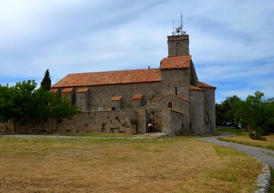
L'église paroissiale - Stefano Blanc - PNR Verdon Patrimony and historyThe parish church
Church completed transition between primitive Romanesque art and the classic dating from the late eleventh century, or early twelfth century the church was enlarged collateral (the thirteenth and fifteenth century), enhanced with a first bell tower 17th century, and the present in the 18th century. Inside, you can admire a beautiful altarpiece of the eighteenth century. (Various statues of the 18th and 19th centuries, two pieces of cancel the sixth (one set in the bedside of the building, the other above a door next to the gate).
360°de panorama exceptionnel ! - Stefano Blanc - PNR Verdon Panorama360°of exceptional panorama!
From the top of this belvedere 7 departments contemplate you! With a panorama of Provence and the Alps where Jean Giono wrote: "Before me stretched the high Var with its deserts and castles It will really be necessary to draw one day the map of non-passable roads for the use of real curious. We make discoveries at every step. We arrive at the top of a hill to see ourselves contained in a landscape that can only push to happiness. "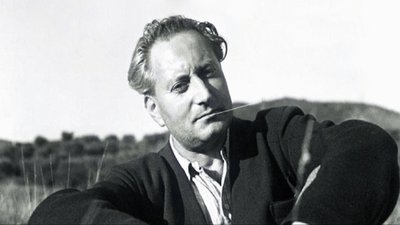
Jean Giono - DR Patrimony and historyJean Giono, the Saint-Juliennois
"If I chose this place is that it is like a belvedere from which is discovered all the Haute-Provence and that it allows a little geography. After the details of the walk of that day: the juniper, the birch, the holm oak, the beech tree that stopped me, the scented grass I chewed on, the lizard, the grass snake, the bird that came from under my feet, the fountain that I I searched for the hamlets I crossed, the dog I talked to, the shepherd with whom we exchanged greetings "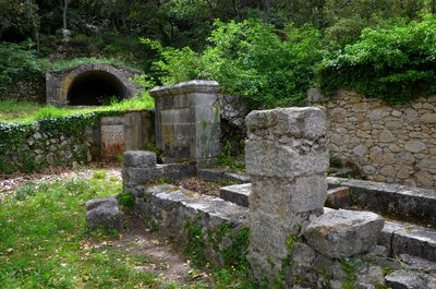
La fontaine - Stefano Blanc - PNR Verdon Patrimony and historyHere are the gold guages
The water supply is difficult here. At the end of the nineteenth century the priest paid himself the installation of two hydraulic rams to bring water to Saint-Julien. But this pumping system only worked for a short time and the inhabitants returned to this fountain, the only one in the village. Its current form dates from the 18th century. The water is drained under the village by a gallery or mine. On the side, the large vaulted tank allowed to store this water so precious.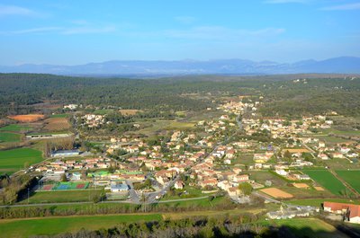
La plaine de Saint Julien et le hameau de Saint-Pierre - Stefano Blanc - PNR Verdon Patrimony and historyPanorama on Saint Pierre
Saint-Pierre is the hamlet among the 28 that is the more important in the municipality, he became, in 1929, the administrative center of the commune, previously located in the old village; At the time, the relocation was at the origin of great controversy, but was it fully justified because in 1926 the number of inhabitants in the lowland was 593 against 77 to the perched village!
Description
From the car park take the stairs and turn right, cross the bridge and take the road that goes to the right of the cooperative cellar "path under the rock".
1 - Before the cemetery turn right on the path of donkey paradise. Arrive at the top on a parking lot take the path on the right.
2 - and continue along a small path on the left. At the top, turn right towards "chemin du Baou". Walk under the ramparts in the shade of the holm oaks, until the cross.
3 - then turn left to arrive in front of the Gourdanne gate. Pass under this one and go up on the left towards "the walk of the belvedere" to pass in front of the Church to make the turn and to go straight down in the village. Pass the Auberge du Montagnier and cross the Gourdanne door then turn right down to the Cross.
3 - just after turn left and follow the path that descends lace Arrive at the place said the Fountain continue to descend.
4 -Take the first path on the right to reach a field on the right, cross a bridge across the D69 and continue facing the path of the old mill, straight and then after 200 m turn right through the municipal camp-site at the end again right to the roundabout continue in front of the grocery store, then the post office and return to the departure bridge.
- Departure : Tourism office car park, St-Pierre
- Arrival : St-Pierre
- Towns crossed : Saint-Julien
Forecast
Altimetric profile
Recommandations
Information desks
House of the Verdon Regional Nature Park
Domaine de Valx, 04360 Moustiers-Sainte-Marie
House of the Verdon Regional Nature Park

OT de Brignoles - Provence Verte & Verdon Tourisme
Boulevard Grisolle, 83670 Barjols
Access and parking
Parking :
More information
Report a problem or an error
If you have found an error on this page or if you have noticed any problems during your hike, please report them to us here: