4. Tour du lac d'Esparron - Etape 4
Une étape féérique ou se mêle passé proche et passé lointain en longeant le Verdon sur les ouvrages Napoléonien du canal de Provence vous apercevrez les grottes préhistoires, puis pénétrez le vallon de St Maxime et ses arbres couvert de mousses, pour parcourir les chemins médiévaux sur l’immense plateau calcaire des bois de Malasoque, et atteindre la forêt d’yeuses qui encercle étroitement le pied du rocher qui porte le bourg médiéval de Saint Julien le Montagnier si cher à Jean Giono.
12 points of interest
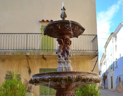
La fontaine aux bambins - ©Stefano Blanc - PNR Verdon  Water and rivers
The fountain for toddlers
Seven of Quinson's eight fountains date from 1877. At that time, the waters of the Verdon were captured and channeled at Quinson to supply the region of Aix-en-Provence. The village was compensated and obtained a direct water supply. Two fountains have their overlaid basins that spread the water emphasize its abundance and indicate a certain ease. The sculptures use symbolic elements: toddlers evoking purity and youth, turtles symbol of eternity ...
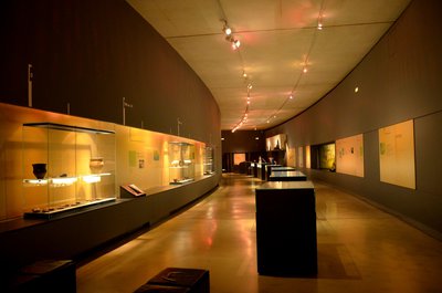
Les salles des collections - ©Stefano Blanc - PNR Verdon  Patrimony and history
The Prehistory Museum
In the heart of the Verdon Regional Nature Park, in Quinson, the Prehistory Museum of the Gorges du Verdon traces the exceptional adventure of Man in Provence since 1 million years. The museographic circuit presents the result of archaeological excavations in the Verdon since more than 50 years: a journey in time accessible to all thanks to a circuit alternating scenes of the daily life of Prehistory, interactive animations and original archaeological objects.
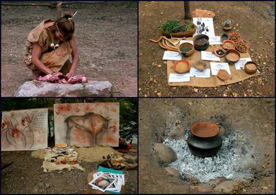
Les ateliers de la Préhistoire - ©Stefano Blanc PNR Verdon Patrimony and historyThe Prehistory Days
A weekend that takes place in mid-July every year: free events for all the family! The Days of Prehistory in Quinson are scientific, educational and recreational events, and make children and adults interested and curious. Known for being one of the most important periods devoted to prehistory in France, Quinson Days offer a comprehensive program of workshops and demonstrations of all types every year. Return to the past guaranteed!!
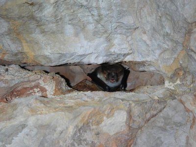
Murin de Capaccini - Stefano Blanc - PNR Verdon  Fauna
FaunaBe careful!
Bats take advantage of the natural and artificial cavities of the low Verdon gorges to hibernate. When they fall asleep, their temperature and heart rate drop and their breathing seems to stop (breathing stops can last from 60 to 90 minutes!). An impromptu awakening would condemn them. The flagship Mediterranean species here is Capaccini's Murin, whose large feet allow it to collect insects (and sometimes fry) on the surface of the water.
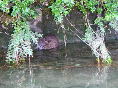
Le ragondin - ©Stefano Blanc - PNR Verdon FaunaAn American in the lower gorges
The Coypu also known as the "river rat" (Myocastor coypus) is a species of mammal in the Myocastoridae family, the only surviving species of the genus Myocastor. This large rodent, native of South America, was introduced in Europe in the 19th century for the exploitation of its fur. All coypus present in Europe have either escaped or were released voluntarily in the open. The coypus has no natural predators except for its young which are sometimes the prey of birds like buzzards and barn owls.
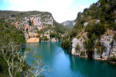
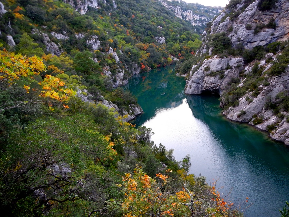
Les basses gorges et les grottes de Sainte-Maxime - Stefano Blanc - PNR Verdon  Panorama
Viewpoint of the lower gorges
A viewpoint which gives you a view of the Sainte Maxime caves.
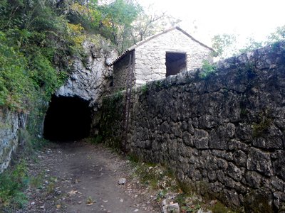
Abri du garde canal - Stefano Blanc - PNR Verdon Patrimony and historyThe first canal of Aix en Provence
The first canal with water intake on the Verdon was built from 1864, it follows the left bank of the lower gorges. The path going along it allowed men assigned to this work to perform maintenance. Its development constituted a hard 10 years of labour, 20km of tunnels were dug for this occasion, with the means of the time, that is to say, the pick, the pickaxe and gunpowder.
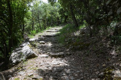
Chemin du paradis des Ânes - Stefano Blanc - PNR Verdon Patrimony and historyThe way to the paradise of Donkeys
This path is quite steep. Half way a flat and shady part was appreciated by the donkeys and their masters who caught their breath! The stony and sloping land, now wild, has harvested almonds and olives. In the saffron trees we cultivated the "crocus sativus" whose stigmas (saffron) brought back big.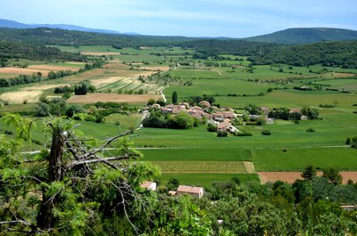
Vue sur les Guis - Stefano Blanc - PNR Verdon PanoramaThe Guis hamlet
The village perched on an isolated hill offers a beautiful view of a succession of rocky plateaus covered with scrubland. Fields of vineyards, cereals, lavender and olive trees bring each season the dominant colours of a changing landscape and a view of several of the 27 hamlets that are on the municipality.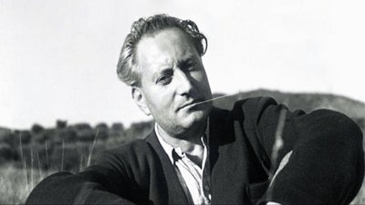
Jean Giono - DR Patrimony and historyJean Giono, the Saint-Juliennois
"If I chose this place is that it is like a belvedere from which is discovered all the Haute-Provence and that it allows a little geography. After the details of the walk of that day: the juniper, the birch, the holm oak, the beech tree that stopped me, the scented grass I chewed on, the lizard, the grass snake, the bird that came from under my feet, the fountain that I I searched for the hamlets I crossed, the dog I talked to, the shepherd with whom we exchanged greetings "
360°de panorama exceptionnel ! - Stefano Blanc - PNR Verdon Panorama360°of exceptional panorama!
From the top of this belvedere 7 departments contemplate you! With a panorama of Provence and the Alps where Jean Giono wrote: "Before me stretched the high Var with its deserts and castles It will really be necessary to draw one day the map of non-passable roads for the use of real curious. We make discoveries at every step. We arrive at the top of a hill to see ourselves contained in a landscape that can only push to happiness. "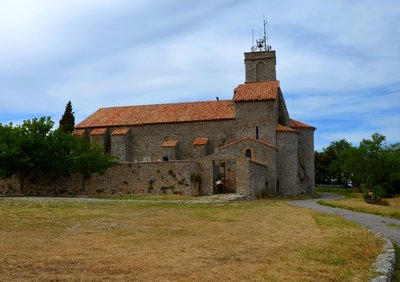
L'église paroissiale - Stefano Blanc - PNR Verdon Patrimony and historyThe parish church
Church completed transition between primitive Romanesque art and the classic dating from the late eleventh century, or early twelfth century the church was enlarged collateral (the thirteenth and fifteenth century), enhanced with a first bell tower 17th century, and the present in the 18th century. Inside, you can admire a beautiful altarpiece of the eighteenth century. (Various statues of the 18th and 19th centuries, two pieces of cancel the sixth (one set in the bedside of the building, the other above a door next to the gate).
Description
Depuis le parking du musée, se diriger vers les berges du Verdon. Prendre à droite au bord de l'eau et rejoindre le pont. Le franchir et gagner à 50 m le départ du sentier des basses gorges.
1- Monter à droite. Rejoindre un premier belvédère et descendre au bord de l'eau. Continuer ainsi sur le sentier historique.
2- À la passerelle du carrefour "la Draille des vaches", aller tout droit. Emprunter sur l’itinéraire deux escaliers métalliques. Cheminer sur le mur du canal (prudence !) avant de pénétrer dans celui-ci et de rejoindre l'abri du garde canal.
3- Franchir un tunnel de 120 m et sortir du canal par un escalier métallique. Remonter le fond du vallon de Sainte-Maxime sur 1 km.
4- Au poteau flèche « la charbonnière » prendre à droite.
5- Puis au poteau flèche « Ravin de St Maxime » bifurquer à nouveau vers la droite pour rejoindre le plateau et suivant le GR®99 (blanc et rouge).
6- Apres la ferme « les cabres du Montagnier » prendre le premier chemin à droite et traverser le hameau des Bernes en suivant le GRP®( jaune et rouge).
7- Poursuivre sur le GRP® et prendre à droite sur 750m.
8- Prendre à gauche vers le hameau des Rouvières, arriver sur la D69 aller à gauche traverser après l’église obliquer vers la droite, passer devant la fontaine et poursuivre sur le GRP®.
9- Suivre le chemin de Saint Joseph pour passer sous le hameau de la Mantuane et rejoindre le chemin goudronné se diriger sur la gauche pendant une centaine de mètres.
10- Monter vers la colline et continuer par le layon sur le GR® puis redescendre vers la plaine.
11- Traverser le chemin et prendre en face légèrement sur la droite, longer le champ et au bout prendre à droite en traversant le pont, continuer et traverser un ruisseau pour arriver à la D35.
12- Traverser en face, monter vers la colline traverser un deuxième chemin et aller tout droit en suivant le balisage GRP® (jaune et rouge).
13- prendre une petite traverse sur la droite et regagner ainsi le village.
- Departure : Quinson
- Arrival : Saint-Julien-le-Montagnier
- Towns crossed : Quinson, Montmeyan, and Saint-Julien
Forecast
Altimetric profile
Recommandations
Information desks
House of the Verdon Regional Nature Park
Domaine de Valx, 04360 Moustiers-Sainte-Marie
House of the Verdon Regional Nature Park

OT de Brignoles - Provence Verte & Verdon Tourisme
Boulevard Grisolle, 83670 Barjols

OT Gréoux-les-Bains
7 place de l'hôtel de ville, 04800 Gréoux-les-Bains

OT Quinson
Chapelle Saint-Esprit, 04500 Quinson
Access and parking
Parking :
Report a problem or an error
If you have found an error on this page or if you have noticed any problems during your hike, please report them to us here: