
5. Tour du lac d'Esparron - Etape 5
Depuis le village pittoresque de Saint-Julien le Montagnier vous allez redescendre vers le hameau de Saint-Pierre pour atteindre à travers la colline les berges du lac en face Esparron de Verdon puis vous allez longer les bords du lac par l’ancien sentier du canal de Provence jusqu’à Saint Julien plage et vous poursuivrez en grimpant vers la chapelle Notre Dame des Œufs qui surplombe ainsi la vallée du Verdon pour arriver enfin au village thermal de Gréoux les Bains une étape plein les yeux !
16 points of interest

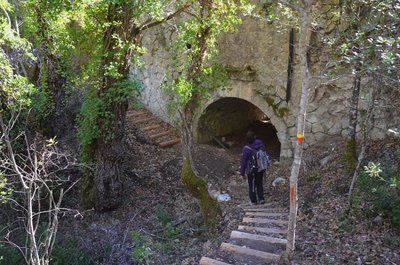
La porte de Gourdane - Stefano Blanc - PNR Verdon  Patrimony and history
The Gourdane gate and ramparts of the 13th century
On the outside we notice especially "the seigniorial stone" of the 13th century. You will notice that the corners of this tower are built with stones that represent a particular shape. They are "hump stones" They are not placed there by chance, but on the contrary to be seen. They highlight the seigniorial origin of the construction of the fortified gate. Inside, we discover an open-mouthed tower that allowed to shelter from the attackers.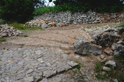
La calade - Stefano Blanc - PNR Verdon  Savoir-faire
The calades, what is this?
The calade is a technique for the gravelling of soils in which the material is the stone, the more often picked up locally. The stones are sunk vertically. It is said then that it is a standing ground to distinguish it from pavement which is a lying ground. Stoned paths were among the main accesses to the village. They allowed to mount all the necessary goods and on a daily basis, the most precious of all: the water.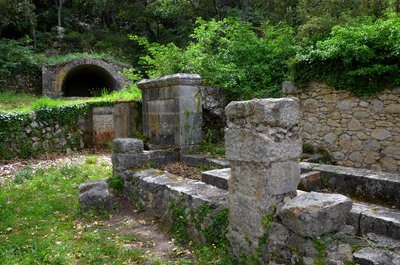
La fontaine - Stefano Blanc - PNR Verdon Patrimony and historyHere are the gold guages
The water supply is difficult here. At the end of the nineteenth century the priest paid himself the installation of two hydraulic rams to bring water to Saint-Julien. But this pumping system only worked for a short time and the inhabitants returned to this fountain, the only one in the village. Its current form dates from the 18th century. The water is drained under the village by a gallery or mine. On the side, the large vaulted tank allowed to store this water so precious.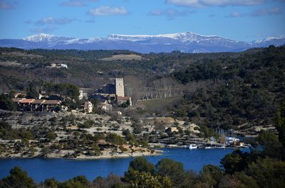
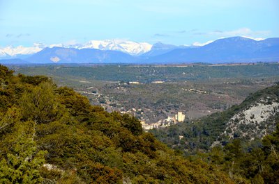
Au loin les Préalpes du Verdon - Stefano Blanc - PNR Verdon  Panorama
Far off the Chiran
From the limestone cliffs overlooking the lake we have a magnificent view of Esparron de Verdon and its castle, we can also see in the distance the snow-capped Mount Chiran which is the second summit of the Verdon Prealps (1 905 m) after its neighbor on the right the Mourre de Chanier (1,930 m). Just above the keep the Grand Mourre (1898 m). The Chiran is separated from the Mourre de Chanier by the Portal of Blieux, col of 1,595 m of altitude.
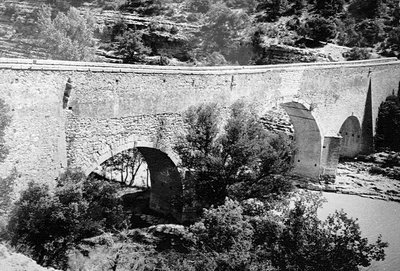
Le pont coupé - DR Patrimony and historyThe cut off bridge
Here the little road seems to flow into the lake. It has not always been so. In 1967, the launching of the lake submerged a stone bridge by 12 meters with three arches that spanning the Verdon connected "Le Quartier" to the rest of the Esparron town. Passage between the Var and the Alpes de Haute-Provence This bridge built in 1725 by the municipality of Arles was a passageway for transhumance herds between the Crau and the pastures of the Pre-Alps avoiding the quirks of the Verdon.
Avec les Alpes ça se vente - Stefano Blanc - PNR Verdon PanoramaBetween Provence and the Alps
Just before going down towards the lake an opening is offered to you with the view on the village of Esparron de Verdon, the immense plateau of Valensole and on the bottom the Alps massifs, you are at the heart of the high Provence, the prevailing winds with evocative names Tremontano - Tems dré - Montagnero - Ventouresco often bring back the freshness of the snow-capped peaks.
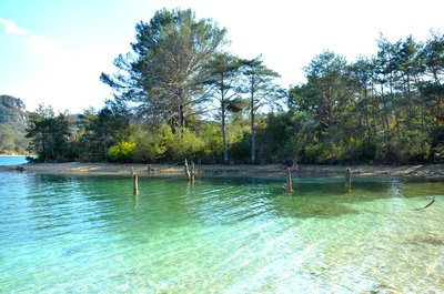
Comme un air de Caraïbes - Stefano Blanc - PNR Verdon  Water and rivers
Like a Caribbean air
The impoundment of Lake Esparron in 1969 drowned the rich agricultural lands of the valley but in return the rise of the waters allowed to redraw the banks leaving sometimes beaches, sometimes steep cliffs, redrawing the landscapes that were transformed into an idyllic place if only by the colour of the water or by creating real small coves.
L'ENS la Barade vue depuis la rive droite - Stefano Blanc - PNR Verdon Patrimony and historySensitive Natural Area
The Sensitive Natural Areas of the Var, known as ENS, are sites located in environments remarkable for their biological diversity. They are inherently fragile, rare or endangered. These treasures of biodiversity are managed according to this fragility. Appropriate amenities enhance their wealth and avoid over-frequenting harmful environments. The County Council strives to preserve the remarkable sites and the landscapes, to safeguard the natural habitats.
L'aqueduc de la Barade - Stefano Blanc - PNR Verdon Patrimony and historyBridge or aqueduct?
Seen from below it looks like a bridge but it is the water of the old canal of Provence that was ended in 1875 which passed over then it is indeed an aqueduct, one of the many remarkable works of this old canal which operated until 1969 and it is the water intake of the canal of Provence with the creation of the lake which took the relay to convey the water until Aix en Provence, Marseilles, and many cities from the south of Provence.
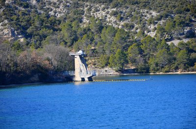
Prise d'eau d'EDF et du canal de Provence - Stefano Blanc - PNR Verdon Patrimony and historyThe intake from the canal de Provence
The first of two large water intakes contributing to the power supply of the EDF Vinon sur Verdon and the Canal de Provence to supply domestic and agricultural water, 116 municipalities, including Marseille, Toulon and Aix-en-Provence. The water then passes through the Maurras Gallery and other galleries and open channels to start as Canal de Provence near Rians.
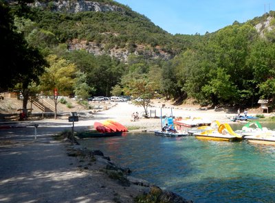
Les plages de Saint-Julien - Stefano Blanc - PNR Verdon Water and riversSaint Julien-Plage
Saint-Julien plage was born at the creation of the lake and over time became a small paradise very popular with locals, a haven of peace where it is good to come to refresh after long sunny days in the shade of the oaks along the banks of the lake.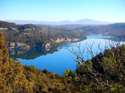
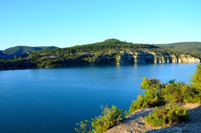
Le lac - Stefano Blanc - PNR Verdon PanoramaThe lake
The lake and its blue waters a gentle breeze soothing silence that's what awaits you when you reach this natural lookout ... nature in its raw state.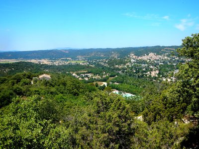
Gréoux et sa plaine - Stefano Blanc - PNR Verdon PanoramaGryselian landscape
Below we can see the Notre-Dame des oeufs easily accessible on foot, it dominates the Verdon. Traditional site of pilgrimage the site offers a pretty point of view on the village and the Verdon lowland.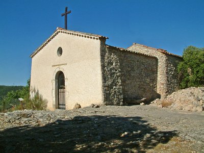
Notre Dame des Oeufs - Stefano Blanc PNR Verdon Patrimony and historyNotre-Dame des Œufs
Notre-Dame des Œufs is a modest 17th century building nestled in a beautiful setting. This worship place is certainly very ancient. Its name derives from a local custom that women who were sterile or wanted to have a child would come with two eggs on Easter Monday. Once they arrived, they had to swallow one and then leave the other one. On a second pilgrimage, on the following September 8, the second egg had to be intact for the wish to come true ....
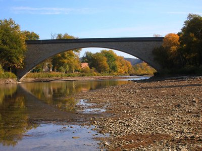
Le pont voûte de Gréoux les Bains - Stefano Blanc - PNR Verdon Patrimony and historyA bridge for nails
August 15, 1944 this bridge was to be bombarded by the English air force, the airmen seeing a colony of children who bathed in the Verdon dropped their bombs in the ravines. The next day they found a destroyed bridge. Resistance members of Greoux had done it for them. In 1950 the state decided to rebuild it in stone as it is today, the formwork of the concrete vault was made with hangers in studded planks it will take 18 months and 7.5 tons of nails.
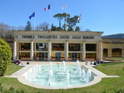
L'entrée des thermes - Stefano Blanc - PNR Verdon Patrimony and historyThermal baths of Gréoux
Called "Romantic Oasis of Verdon" by Jean Giono, this spa, nestled in a multifaceted and generous nature at the gates of the Verdon Nature Park, is a great place for your family fun. Gréoux is known since Antiquity under the name of Nymphis Grisélidis, in relation to the hot springs (nymphs are the deities of springs), converted in thermal baths by the Romans. After a long period of neglect, the baths were revived at the end of the 17th century.
Description
Depuis la rue principale aller tout droit en suivant le balisage GRP ® (jaune et rouge).
1- Passer sous la porte de la Gourdanne, prendre à droite et redescendre vers la Croix.
2- Prendre à gauche et descendre par le chemin en lacet.
3-Prendre le premier chemin sur la droite et continuer vers la D69 traverser en face vers le chemin du vieux moulin, tout droit puis après 200 m prendre à droite la traverse du camping municipal, au bout à droite jusqu’au rond-point.
4- Prendre à gauche rue de Terdobbiate sur 1 km.
5- Poursuivre sur la gauche traverser le hameau et s’engager dans la colline jusqu’à rejoindre une piste.
6- Prendre à droite continuer sur la piste.
7- A la barrière prendre à droite et cheminer en suivant le balisage GRP®.
8- A la citerne descendre sur la gauche pour atteindre le lac d’Esparron.(Attention vous allez randonner sur un ENS Espace Naturel Sensible, ne pas sortir du sentier balisé, pas de cueillette, pas de construction de cairns).
9- Passer devant la maison de la SCP prendre à droite, descendre sur une centaine de mètres puis s’engager sur le sentier à gauche monter légèrement et parcourir le sentier en suivant le balisage. Longer les berges du lac et faites le tour des pelouses par le chemin puis traverser l’ancien canal et remonter par la grande piste en galets.
10- Tourner à droite au poteau flèche et gagner les falaises Puis redescendre vers le lac pour atteindre le sentier du garde canal. Longer les berges du lac avec le sentier en respectant bien le balisage (jaune et rouge).
11- Rejoindre la route goudronnée et la suivre pendant 3 km 700 puis bifurquer sur la droite.
12- Monter vers la chapelle Notre Dame des Œufs. Puis redescendre vers la route du lac.
13- Tourner à droite et continuer pour rejoindre le pont du Verdon à l’entrée de Gréoux les Bains.
14- Apres le pont bifurquer sur la droite par un petit chemin qui descend au bord du Verdon.
15- Apres la guinguette virer à gauche et rejoindre le parking des termes et le village de Gréoux les Bains.
- Departure : Saint-Julien le Montagnier
- Arrival : Gréoux-les-Bains
- Towns crossed : Saint-Julien, Esparron-de-Verdon, and Gréoux-les-Bains
Forecast
Altimetric profile
Recommandations
Information desks
House of the Verdon Regional Nature Park
Domaine de Valx, 04360 Moustiers-Sainte-Marie
House of the Verdon Regional Nature Park

OT de Brignoles - Provence Verte & Verdon Tourisme
Boulevard Grisolle, 83670 Barjols

OT Gréoux-les-Bains
7 place de l'hôtel de ville, 04800 Gréoux-les-Bains
Access and parking
Parking :
Report a problem or an error
If you have found an error on this page or if you have noticed any problems during your hike, please report them to us here: