The tour of the Esparron lake
"The tour of Lake Esparron for me is much more than a hike full of charm in the heart of Haute Provence which is offered to you, it is especially an invitation to the intimate and fascinating discovery of the lake of its characters villages all loaded with stories : prehistoric, Celtic-Ligurian, Roman, medieval, passing in front of remarkable works in an authentic, preserved, generous nature with landscapes and breathtaking views. "Stefano Blanc eco-guard PNRV hiking.
5 steps
44 points of interest
La médiathéque Lucien Jacques - Stefano Blanc - PNR Verdon  Patrimony and history
You would like to lend a book?
There's nothing like a walk along water edges to read a book, to share a story with family and friends. Novels, comics, newspapers, etc... are waiting to be borrowed at the Lucien Jacques de Gréoux library. This is without taking into account its fine collection of regional works, then this may be the opportunity for you to learn a little more about the Verdon?
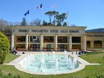
L'entrée des thermes - Stefano Blanc - PNR Verdon Patrimony and historyThermal baths of Gréoux
Called "Romantic Oasis of Verdon" by Jean Giono, this spa, nestled in a multifaceted and generous nature at the gates of the Verdon Nature Park, is a great place for your family fun. Gréoux is known since Antiquity under the name of Nymphis Grisélidis, in relation to the hot springs (nymphs are the deities of springs), converted in thermal baths by the Romans. After a long period of neglect, the baths were revived at the end of the 17th century.
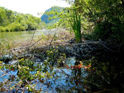
Hutte à castor - Stefano Blanc - PNR Verdon - Stefano Blanc - PNR Verdon  Fauna
FaunaBeaver lodge
More typical of wetlands, semi-aquatic mammals such as the Eurasian beaver (Castor fiber) are present in the water stream of the Verdon. The beaver, with its nocturnal habits, and sometimes coming out at dusk if it is not disturbed is a discreet animal. Its presence is easily detected due to the many tracks left: fallen and eaten-away trees, tree branch barks, it builds a large hut made of branches with submerged entries. National protection of the species and its habitat.
Les zones humides - Stefano Blanc - PNR Verdon  Water and rivers
Emergency water
The Verdon bank is colonized by a particular and rare flora in Provence, that of wetlands. Willows, poplars represent the majority of the trees present. At the waterfront, a procession of rushes and sedges. At the bottom of the Verdon itself, aquatic plants line it in quieter areas. This vegetation threatened by trampling, shoreline development and deterioration of water quality are some of the current challenges of preserving the natural heritage.
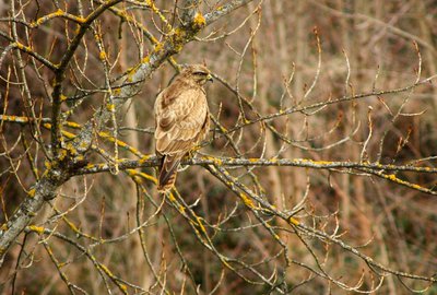
La Buse variable - Stefano Blanc PNR Verdon FaunaThe best view
The common buzzard is very active, often flying in the open, gliding over fields and forests, and also spending long periods hovering high. It feeds on small mammals it chases on the ground, and also birds, reptiles, amphibians and insects. The preys are located by sight, flying at low altitude while making circles, but also at distances of a few hundred meters. We consider that the common buzzard has the sharpest sight of all birds of prey.
Eglise paroissiale Saint-Martin - ©Stefano Blanc - PNR Verdon Patrimony and historyParish church of Saint-Martin
The parish church of Saint-Martin is a former priory of the abbey of Saint-Victor de Marseille it has received from the hands of the brothers Gontard and Hughes in 1042. The term "ecclesiam" mentioned in the act can also mean a territory. This transaction confirms that Saint-Martin was at that time a monastic domain and no longer a seigniorial one. An Act of 13 March 1343 mentioned the exchange between Saint-Victor and Boniface de Castellane, allowing him to recover the land of Saint-Martin.
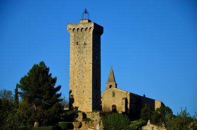
La Tour de l'horloge - ©Stefano Blanc - PNR Verdon Patrimony and historyThe Clock Tower
The tower was built in the 14th century on the initiative of Boniface de Castellane, the Lord at that time. It is now recognized as the most beautiful military building work of Haute-Provence. Its military aspect is clear, but its function seems less defensive. It could be used to store the seigniorial tax (in the form of food). We can speak of "dungeon" marking conspicuously the power of the Lord. At the top, the machicolations allowed to defend itself if attacked.
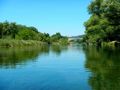
Le Colostre - ©Stefano Blanc - PNR Verdon Water and riversThe Colostre
This river has marked its history. In Roman times, the Colostre was an important axis of development. Later, the inhabitants of the valley domesticated it and used it for agricultural purposes. A network of canals ran through the valley. The water intakes are still visible. They cultivated tulip, beans or mulberry trees. Shepherds let their sheep to graze on the banks. Today, the Colostre is identified as a major biological reservoir to restore and preserve.
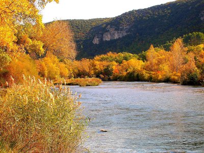
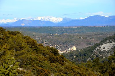
La basse vallée du Verdon - Stefano Blanc - PNR Verdon Water and riversThe Verdon valley
Give yourself a magnificent view of the lower valley of the Verdon since the small natural belvedere, it is also here that the Colostre flows into the Verdon.
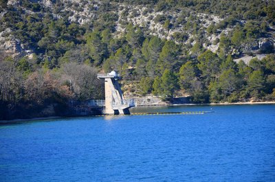
Le barrage de Gréoux - Stefano Blanc - PNR Verdon Patrimony and historyThe Esparron dam
A magnificent view of the Verdon valley and the Gréoux dam which is a hydroelectric structure on the Verdon, located between two departments that of the Var and the Alpes-de-Haute-Provence, it allows a reservoir of water of 80 million m3, Lake Esparron, which supplies the Vinon power station and the Provence Canal. The building belongs to EDF and provides 170 million kWh per year. It is an earthen dam 260 m thick at the base, 67 m high and 220 m long.

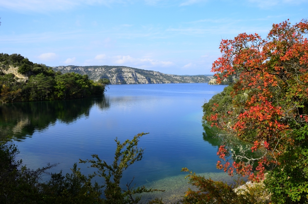
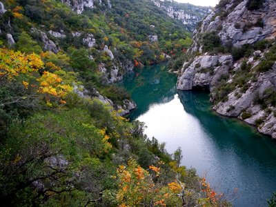
Le lac au couchant - Stefano Blanc - PNR Verdon  Panorama
The lake at sunset
A beautiful view of Lake Esparron the green of the lake turns into steel blue with the setting sun.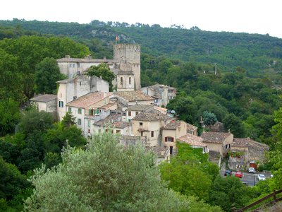
Le village et son château - ©Stefano Blanc - PNR Verdon Patrimony and historyEsparron village
You will see the oldest part of the medieval village of Esparron nestled against its castle and its protective dungeon.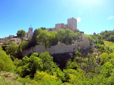
Le quartier de Vière - Stefano Blanc - PNR Verdon Patrimony and historyOnce upon a time, Vière...
Located below the castle of Esparron-de-Verdon, the Vière area, historic heart of the village, did not resist the rural exodus and was abandoned by its inhabitants. It is now in ruins, nature has reasserted itself. After rehabilitation, the site is revived and is now accessible, secured and landscaped. This is an area for strolls, between vegetation and ruins, their stones being a remembrance, which offers magnificent views of the village and the lake.
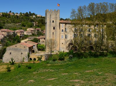
Le donjon du Baron - ©Stefano Blanc - PNR Verdon Patrimony and historyThe Baron's dungeon
The memory of Boniface VI of Castellane, a fierce baron and impetuous troubadour who lived in the 13th century, still hangs over Esparron-de-Verdon, and more particularly in the renowned dungeon of his castle. Because this mighty building with its massive battlements reflects the ardour of Boniface, who challenged the new Count of Provence, Charles of Anjou, whom he called scornfully "franciot" (little Frenchman).
Le pont noyé sous le lac - DR Patrimony and historyEsparron, the small medieval lock
It was easy to cross Verdon to Esparron, the waters were calmer at the mouth of the lower gorges. A bridge, nowadays submerged by the waters of the lake, was built there in 1725. The village had therefore define an important route between Var and Haute-Provence. Its function itself is specified in its name. The medieval "Espar" is a lock. And what is this town locking? The great path, which of course, it is carefully monitoring at this period.
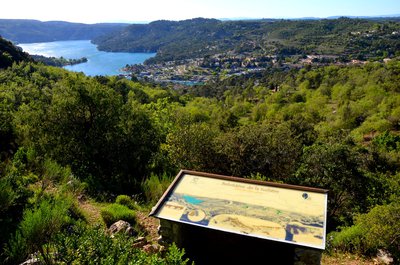
Ne perdons pas le Nord - ©Stefano Blanc - PNR Verdon PanoramaThe Viewpoint Indicator Map
The viewpoint indicator map located 498m high provides views of the lake and the port of the town of Esparron du Verdon. In the distance, we can see the massif of Luberon and the Lure mountain
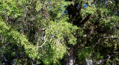
Le Mourven des provençaux - ©Stefano Blanc - PNR Verdon  Flora
FloraThe Phoenician Juniper or Mourven Provencal
It is the second Mediterranean juniper that immediately differs from its cousin, the Cade, by its innumerable ramules covered with tiny tortoiseshell leaves. Its range is also less extensive. Very xerophile, he likes the poorest scrubland, cracks of rocks and even limestone cliffs where his red brick balls defy the most insane sunshine and aridity almost absolute.
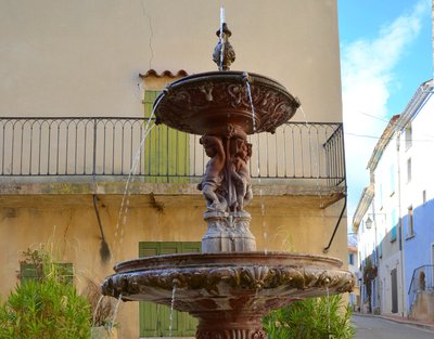
La fontaine aux bambins - ©Stefano Blanc - PNR Verdon Water and riversThe fountain for toddlers
Seven of Quinson's eight fountains date from 1877. At that time, the waters of the Verdon were captured and channeled at Quinson to supply the region of Aix-en-Provence. The village was compensated and obtained a direct water supply. Two fountains have their overlaid basins that spread the water emphasize its abundance and indicate a certain ease. The sculptures use symbolic elements: toddlers evoking purity and youth, turtles symbol of eternity ...
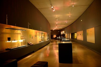
Les salles des collections - ©Stefano Blanc - PNR Verdon Patrimony and historyThe Prehistory Museum
In the heart of the Verdon Regional Nature Park, in Quinson, the Prehistory Museum of the Gorges du Verdon traces the exceptional adventure of Man in Provence since 1 million years. The museographic circuit presents the result of archaeological excavations in the Verdon since more than 50 years: a journey in time accessible to all thanks to a circuit alternating scenes of the daily life of Prehistory, interactive animations and original archaeological objects.
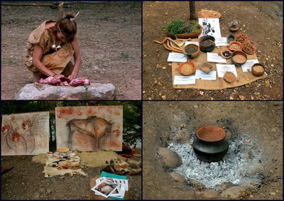
Les ateliers de la Préhistoire - ©Stefano Blanc PNR Verdon Patrimony and historyThe Prehistory Days
A weekend that takes place in mid-July every year: free events for all the family! The Days of Prehistory in Quinson are scientific, educational and recreational events, and make children and adults interested and curious. Known for being one of the most important periods devoted to prehistory in France, Quinson Days offer a comprehensive program of workshops and demonstrations of all types every year. Return to the past guaranteed!!
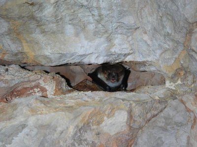
Murin de Capaccini - Stefano Blanc - PNR Verdon FaunaBe careful!
Bats take advantage of the natural and artificial cavities of the low Verdon gorges to hibernate. When they fall asleep, their temperature and heart rate drop and their breathing seems to stop (breathing stops can last from 60 to 90 minutes!). An impromptu awakening would condemn them. The flagship Mediterranean species here is Capaccini's Murin, whose large feet allow it to collect insects (and sometimes fry) on the surface of the water.
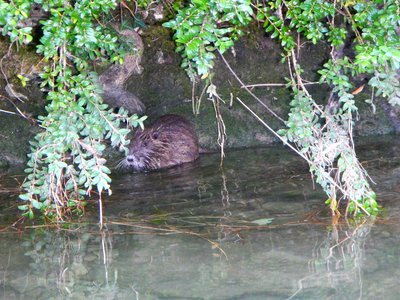
Le ragondin - ©Stefano Blanc - PNR Verdon FaunaAn American in the lower gorges
The Coypu also known as the "river rat" (Myocastor coypus) is a species of mammal in the Myocastoridae family, the only surviving species of the genus Myocastor. This large rodent, native of South America, was introduced in Europe in the 19th century for the exploitation of its fur. All coypus present in Europe have either escaped or were released voluntarily in the open. The coypus has no natural predators except for its young which are sometimes the prey of birds like buzzards and barn owls.
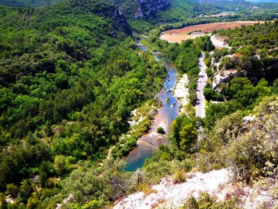
Les basses gorges et les grottes de Sainte-Maxime - Stefano Blanc - PNR Verdon PanoramaViewpoint of the lower gorges
A viewpoint which gives you a view of the Sainte Maxime caves.
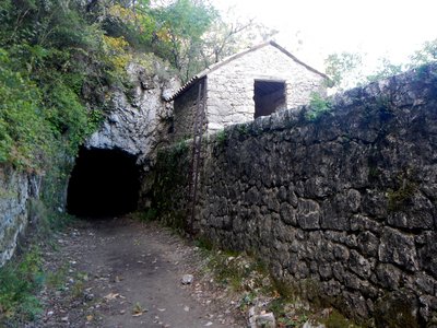
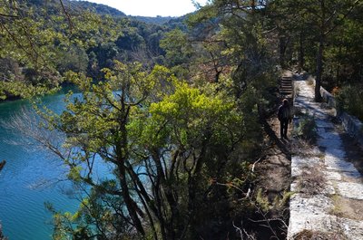
Abri du garde canal - Stefano Blanc - PNR Verdon Patrimony and historyThe first canal of Aix en Provence
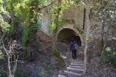
The first canal with water intake on the Verdon was built from 1864, it follows the left bank of the lower gorges. The path going along it allowed men assigned to this work to perform maintenance. Its development constituted a hard 10 years of labour, 20km of tunnels were dug for this occasion, with the means of the time, that is to say, the pick, the pickaxe and gunpowder.
Chemin du paradis des Ânes - Stefano Blanc - PNR Verdon Patrimony and historyThe way to the paradise of Donkeys
This path is quite steep. Half way a flat and shady part was appreciated by the donkeys and their masters who caught their breath! The stony and sloping land, now wild, has harvested almonds and olives. In the saffron trees we cultivated the "crocus sativus" whose stigmas (saffron) brought back big.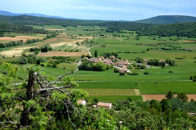
Vue sur les Guis - Stefano Blanc - PNR Verdon PanoramaThe Guis hamlet
The village perched on an isolated hill offers a beautiful view of a succession of rocky plateaus covered with scrubland. Fields of vineyards, cereals, lavender and olive trees bring each season the dominant colours of a changing landscape and a view of several of the 27 hamlets that are on the municipality.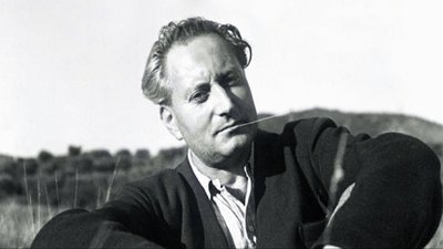
Jean Giono - DR Patrimony and historyJean Giono, the Saint-Juliennois
"If I chose this place is that it is like a belvedere from which is discovered all the Haute-Provence and that it allows a little geography. After the details of the walk of that day: the juniper, the birch, the holm oak, the beech tree that stopped me, the scented grass I chewed on, the lizard, the grass snake, the bird that came from under my feet, the fountain that I I searched for the hamlets I crossed, the dog I talked to, the shepherd with whom we exchanged greetings "
360°de panorama exceptionnel ! - Stefano Blanc - PNR Verdon Panorama360°of exceptional panorama!
From the top of this belvedere 7 departments contemplate you! With a panorama of Provence and the Alps where Jean Giono wrote: "Before me stretched the high Var with its deserts and castles It will really be necessary to draw one day the map of non-passable roads for the use of real curious. We make discoveries at every step. We arrive at the top of a hill to see ourselves contained in a landscape that can only push to happiness. "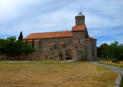
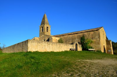
L'église paroissiale - Stefano Blanc - PNR Verdon Patrimony and historyThe parish church
Church completed transition between primitive Romanesque art and the classic dating from the late eleventh century, or early twelfth century the church was enlarged collateral (the thirteenth and fifteenth century), enhanced with a first bell tower 17th century, and the present in the 18th century. Inside, you can admire a beautiful altarpiece of the eighteenth century. (Various statues of the 18th and 19th centuries, two pieces of cancel the sixth (one set in the bedside of the building, the other above a door next to the gate).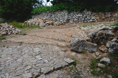
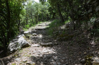
La calade - Stefano Blanc - PNR Verdon  Savoir-faire
The calades, what is this?
The calade is a technique for the gravelling of soils in which the material is the stone, the more often picked up locally. The stones are sunk vertically. It is said then that it is a standing ground to distinguish it from pavement which is a lying ground. Stoned paths were among the main accesses to the village. They allowed to mount all the necessary goods and on a daily basis, the most precious of all: the water.
La porte de Gourdane - Stefano Blanc - PNR Verdon Patrimony and historyThe Gourdane gate and ramparts of the 13th century
On the outside we notice especially "the seigniorial stone" of the 13th century. You will notice that the corners of this tower are built with stones that represent a particular shape. They are "hump stones" They are not placed there by chance, but on the contrary to be seen. They highlight the seigniorial origin of the construction of the fortified gate. Inside, we discover an open-mouthed tower that allowed to shelter from the attackers.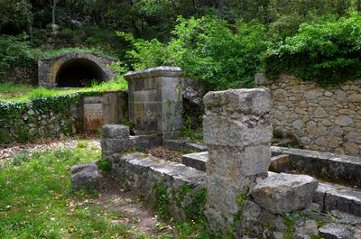
La fontaine - Stefano Blanc - PNR Verdon Patrimony and historyHere are the gold guages
The water supply is difficult here. At the end of the nineteenth century the priest paid himself the installation of two hydraulic rams to bring water to Saint-Julien. But this pumping system only worked for a short time and the inhabitants returned to this fountain, the only one in the village. Its current form dates from the 18th century. The water is drained under the village by a gallery or mine. On the side, the large vaulted tank allowed to store this water so precious.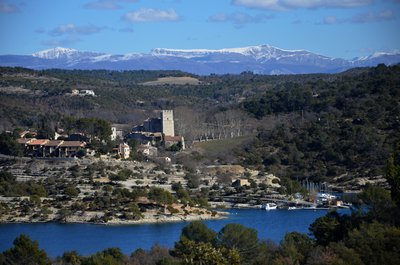
Au loin les Préalpes du Verdon - Stefano Blanc - PNR Verdon PanoramaFar off the Chiran
From the limestone cliffs overlooking the lake we have a magnificent view of Esparron de Verdon and its castle, we can also see in the distance the snow-capped Mount Chiran which is the second summit of the Verdon Prealps (1 905 m) after its neighbor on the right the Mourre de Chanier (1,930 m). Just above the keep the Grand Mourre (1898 m). The Chiran is separated from the Mourre de Chanier by the Portal of Blieux, col of 1,595 m of altitude.
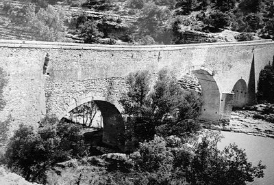
Le pont coupé - DR Patrimony and historyThe cut off bridge
Here the little road seems to flow into the lake. It has not always been so. In 1967, the launching of the lake submerged a stone bridge by 12 meters with three arches that spanning the Verdon connected "Le Quartier" to the rest of the Esparron town. Passage between the Var and the Alpes de Haute-Provence This bridge built in 1725 by the municipality of Arles was a passageway for transhumance herds between the Crau and the pastures of the Pre-Alps avoiding the quirks of the Verdon.
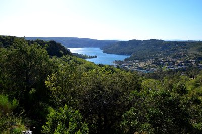
Avec les Alpes ça se vente - Stefano Blanc - PNR Verdon PanoramaBetween Provence and the Alps
Just before going down towards the lake an opening is offered to you with the view on the village of Esparron de Verdon, the immense plateau of Valensole and on the bottom the Alps massifs, you are at the heart of the high Provence, the prevailing winds with evocative names Tremontano - Tems dré - Montagnero - Ventouresco often bring back the freshness of the snow-capped peaks.
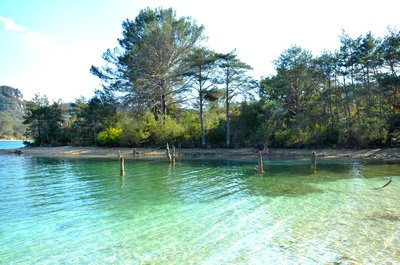
Comme un air de Caraïbes - Stefano Blanc - PNR Verdon Water and riversLike a Caribbean air
The impoundment of Lake Esparron in 1969 drowned the rich agricultural lands of the valley but in return the rise of the waters allowed to redraw the banks leaving sometimes beaches, sometimes steep cliffs, redrawing the landscapes that were transformed into an idyllic place if only by the colour of the water or by creating real small coves.
L'ENS la Barade vue depuis la rive droite - Stefano Blanc - PNR Verdon Patrimony and historySensitive Natural Area
The Sensitive Natural Areas of the Var, known as ENS, are sites located in environments remarkable for their biological diversity. They are inherently fragile, rare or endangered. These treasures of biodiversity are managed according to this fragility. Appropriate amenities enhance their wealth and avoid over-frequenting harmful environments. The County Council strives to preserve the remarkable sites and the landscapes, to safeguard the natural habitats.
L'aqueduc de la Barade - Stefano Blanc - PNR Verdon Patrimony and historyBridge or aqueduct?
Seen from below it looks like a bridge but it is the water of the old canal of Provence that was ended in 1875 which passed over then it is indeed an aqueduct, one of the many remarkable works of this old canal which operated until 1969 and it is the water intake of the canal of Provence with the creation of the lake which took the relay to convey the water until Aix en Provence, Marseilles, and many cities from the south of Provence.
Prise d'eau d'EDF et du canal de Provence - Stefano Blanc - PNR Verdon Patrimony and historyThe intake from the canal de Provence
The first of two large water intakes contributing to the power supply of the EDF Vinon sur Verdon and the Canal de Provence to supply domestic and agricultural water, 116 municipalities, including Marseille, Toulon and Aix-en-Provence. The water then passes through the Maurras Gallery and other galleries and open channels to start as Canal de Provence near Rians.
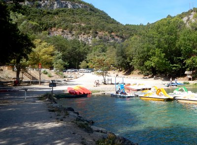
Les plages de Saint-Julien - Stefano Blanc - PNR Verdon Water and riversSaint Julien-Plage
Saint-Julien plage was born at the creation of the lake and over time became a small paradise very popular with locals, a haven of peace where it is good to come to refresh after long sunny days in the shade of the oaks along the banks of the lake.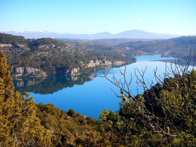
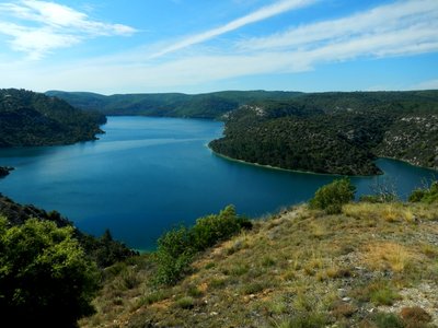
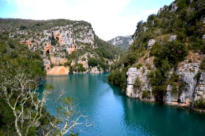
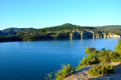
Le lac - Stefano Blanc - PNR Verdon PanoramaThe lake
The lake and its blue waters a gentle breeze soothing silence that's what awaits you when you reach this natural lookout ... nature in its raw state.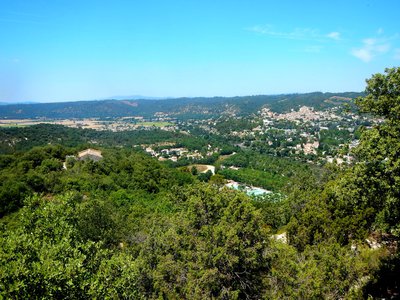
Gréoux et sa plaine - Stefano Blanc - PNR Verdon PanoramaGryselian landscape
Below we can see the Notre-Dame des oeufs easily accessible on foot, it dominates the Verdon. Traditional site of pilgrimage the site offers a pretty point of view on the village and the Verdon lowland.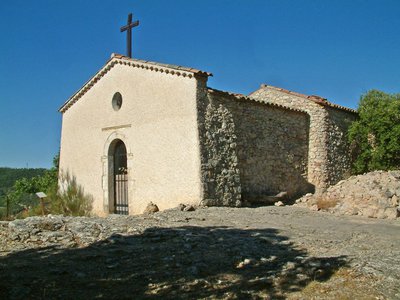
Notre Dame des Oeufs - Stefano Blanc PNR Verdon Patrimony and historyNotre-Dame des Œufs
Notre-Dame des Œufs is a modest 17th century building nestled in a beautiful setting. This worship place is certainly very ancient. Its name derives from a local custom that women who were sterile or wanted to have a child would come with two eggs on Easter Monday. Once they arrived, they had to swallow one and then leave the other one. On a second pilgrimage, on the following September 8, the second egg had to be intact for the wish to come true ....
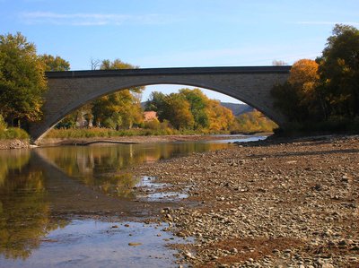
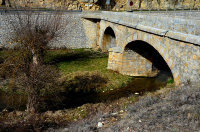
Le pont voûte de Gréoux les Bains - Stefano Blanc - PNR Verdon Patrimony and historyA bridge for nails
August 15, 1944 this bridge was to be bombarded by the English air force, the airmen seeing a colony of children who bathed in the Verdon dropped their bombs in the ravines. The next day they found a destroyed bridge. Resistance members of Greoux had done it for them. In 1950 the state decided to rebuild it in stone as it is today, the formwork of the concrete vault was made with hangers in studded planks it will take 18 months and 7.5 tons of nails.
Description
The first of the five steps of this roaming from Gréoux-les-Bains, is short and presents no particular technical difficulty if not the climb on the crests of Jas de Laube which allows to join the opposite side the village of Saint -Martin-de-Brômes The 2nd day begins with the crossing of the oppidums celto Liguria and then walk on the hills where splendid views of the dam and Lake Esparron are revealed. The 3rd step, easier than the previous one, allows on the heights to easily reach Esparron-de-Verdon and Quinson. The 4th stage, the longest and most technical, rushes into the lower gorges then goes up the left bank of the Verdon on the plateau of Mallasoque. The route then passes to the hamlets of Bernes and Rouvières, to finally reach the medieval village of Saint-Julien le Montagnier, perched on its rocky peak. The last long step and also physical, returns to the banks of Lake Esparron. The overhanging passage of the banks on the old channel, makes it possible to reach Saint-Julien beach. Then the route goes up on the heights, reaches the chapel Notre Dame des oeufs and finally switches to Gréoux-les-Bains, the end of the trip.
- Departure : Gréoux-les-Bains
- Arrival : Gréoux-les-Bains
- Towns crossed : Gréoux-les-Bains, Saint-Martin-de-Brômes, Esparron-de-Verdon, Quinson, Montmeyan, and Saint-Julien
Forecast
Altimetric profile
Recommandations
Information desks
House of the Verdon Regional Nature Park
Domaine de Valx, 04360 Moustiers-Sainte-Marie
House of the Verdon Regional Nature Park

OT de Brignoles - Provence Verte & Verdon Tourisme
Boulevard Grisolle, 83670 Barjols

OT Gréoux-les-Bains
7 place de l'hôtel de ville, 04800 Gréoux-les-Bains
Access and parking
Parking :
Report a problem or an error
If you have found an error on this page or if you have noticed any problems during your hike, please report them to us here: